U.S. Highway 163
| |
|---|---|
| Karte | |
 | |
| Basisdaten | |
| Gesamtlänge: | 64 mi/ 103 km |
| Eröffnung: | 1971 |
| Bundesstaaten: | Arizona Utah |
| Anfangspunkt: | |
| Endpunkt: | |
Der U.S. Highway 163 (kurz: US 163) ist ein United States Highway in den Vereinigten Staaten mit einer Länge von 103 km.
Er verläuft in Nord-Süd-Richtung mit den Endpunkten Bluff im Norden und Kayenta im Süden. Die Straße durchquert die Bundesstaaten Arizona und Utah auf dem Colorado-Plateau mit seinen bekannten Erosionsformen in rotem Sandstein. Ein 77 km langer Abschnitt, der wegen seiner spektakulären Landschaft auch als National Scenic Byway ausgezeichnet ist, verläuft durch die Navajo Nation. Dazu gehört der Abschnitt entlang des Monument Valley, der oft in bekannten Filmen gezeigt wurde, oder auch unmittelbar nördlich von Kayenta der Ausblick auf den Vulkanschlot Agathla Peak und einige andere Erscheinungsformen des Navajo Volcanic Fields.
Entgegen dem üblichen System der Nummernvergabe des AASHTO, wonach der US 163 eigentlich ein Zubringer beziehungsweise eine Umgehungsroute des U.S. Highways 63 sein müsste, gibt es zwischen ihnen keine Beziehung.
Geschichte
Zwischen den Jahren 1962 und 1971 trug die Straße die Bezeichnung Arizona State Route 464 und wurde 1971 zum U.S. Highway heraufgestuft.

U.S. Highway 163

US 163: Monument Valley
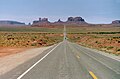
US 163: Navajoland
Weblinks
- End of US Highways (englisch)
- Arizona Roads (englisch)
U.S. Highway 1 | 2 | 3 | 4 | 5 | 6 | 7 | 8 | 9 | 10 | 11 | 12 | 13 | 14 | 15 | 16 | 17 | 18 | 19 | 20 | 21 | 22 | 23 | 24 | 25 | 26 | 27 | 28 | 29 | 30 | 31 | 32 | 33 | 34 | 35 | 36 | 37 | 38 | 40 | 41 | 42 | 43 | 44 | 45 | 46 | 48 | 49 | 50 | 51 | 52 | 53 | 54 | 55 | 56 | 57 | 58 | 59 | 60 | 61 | 62 | 63 | 64 | 65 | 66 | 67 | 68 | 69 | 70 | 71 | 72 | 73 | 74 | 75 | 76 | 77 | 78 | 79 | 80 | 81 | 82 | 83 | 84 | 85 | 87 | 89 | 89A | 90 | 91 | 92 | 93 | 94 | 95 | 96 | 97 | 98 | 99 | 101 | 150 | 151 | 163 | 218 | 400 | 412 | 425
Diese Liste enthält die Hauptrouten des U.S.-Highway-Systems. Nebenrouten sind vom Artikel der jeweiligen Hauptroute (mit identischen Endziffern) erreichbar.
Siehe auch: Liste der United-States-Highways.
Auf dieser Seite verwendete Medien

Autor/Urheber: Wolfgang Staudt from Saarbruecken, Germany, Lizenz: CC BY 2.0
U.S. Route 163 near Monument Valley, Arizona.

Autor/Urheber: Adbar, Lizenz: CC BY-SA 3.0
U.S. Route 163 seen towards northeast.

750 mm × 600 mm (30 in × 24 in) U.S. Highway shield, made to the specifications of the 2004 edition of Standard Highway Signs. (Note that there is a missing "J" label on the left side of the diagram.) Uses the Roadgeek 2005 fonts. (United States law does not permit the copyrighting of typeface designs, and the fonts are meant to be copies of a U.S. Government-produced work anyway.)

750 mm × 600 mm (30 in × 24 in) U.S. Highway shield, made to the specifications of the 2004 edition of Standard Highway Signs. (Note that there is a missing "J" label on the left side of the diagram.) Uses the Roadgeek 2005 fonts. (United States law does not permit the copyrighting of typeface designs, and the fonts are meant to be copies of a U.S. Government-produced work anyway.)

600 mm × 600 mm (24 in × 24 in) U.S. Highway shield, made to the specifications of the 2004 edition of Standard Highway Signs. (Note that there is a missing "J" label on the left side of the diagram.) Uses the Roadgeek 2005 fonts. (United States law does not permit the copyrighting of typeface designs, and the fonts are meant to be copies of a U.S. Government-produced work anyway.)

750 mm × 600 mm (30 in × 24 in) U.S. Highway shield, made to the specifications of the 2004 edition of Standard Highway Signs. (Note that there is a missing "J" label on the left side of the diagram.) Uses the Roadgeek 2005 fonts. (United States law does not permit the copyrighting of typeface designs, and the fonts are meant to be copies of a U.S. Government-produced work anyway.)

