U-Bahn-Linie G (New York City)
 Brooklyn-Queens Crosstown Local | |||||||||||||||||||||||||||||||||||||
|---|---|---|---|---|---|---|---|---|---|---|---|---|---|---|---|---|---|---|---|---|---|---|---|---|---|---|---|---|---|---|---|---|---|---|---|---|---|
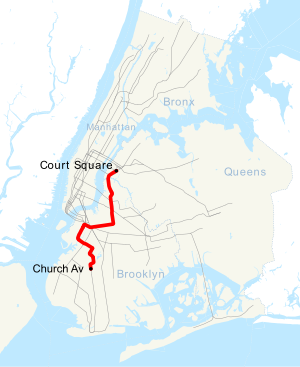
Geographischer Plan New Yorks mit der Linie G | |||||||||||||||||||||||||||||||||||||
| Spurweite: | 1435 mm (Normalspur) | ||||||||||||||||||||||||||||||||||||
| |||||||||||||||||||||||||||||||||||||
| Erklärung | |||||||||||||||||||||||||||||||||||||
| Gezeigt werden ausschließlich Knotenpunkte und Endpunkte. Fett geschriebene Stationen werden zu allen Tageszeiten bedient. | |||||||||||||||||||||||||||||||||||||
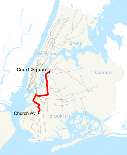
Die Linie G ist eine Linie der New York City Subway und fährt von Court Square in Long Island City über die IND Crosstown Line und IND Culver Line nach Church Avenue in Kensington. Da sie auf der Stammstrecke zwischen Queens und Brooklyn verkehrt, trägt sie die Linienkennfarbe Hellgrün und wird auch als Brooklyn-Queens Crosstown Local bezeichnet.
Sie verbindet Queens und Brooklyn im Westen der beiden Bezirke und bedient die Stadtteile Long Island City, Greenpoint, Williamsburg, Downtown Brooklyn, Red Hook, Park Slope und Kensington. Als einzige Stammlinie bedient sie nicht Manhattan (bei allen anderen Linien, die Manhattan nicht bedienen, handelt es sich um sogenannte Shuttle-Linien).
Die Züge der Linie G verkehren auf ihrer gesamten Strecke als „Local“, die an allen Stationen der Strecke halten. Die Linie G verkehrt rund um die Uhr an allen Tagen der Woche ohne Veränderungen der Streckenführung oder Halten.
Weblinks
Auf dieser Seite verwendete Medien
Bullet for the 7 Local service of the New York City Subway.
Bullet for the E Local service of the New York City Subway.
Bullet for the M Local service of the New York City Subway.
Bullet for the L Local service of the New York City Subway.
Bullet for the A Local service of the New York City Subway.
Bullet for the C Local service of the New York City Subway.
Bullet for the G Local service of the New York City Subway.
Bullet for the R Local service of the New York City Subway.
Bullet for the F Local service of the New York City Subway.
Bullet for the 1 Local service of the New York City Subway.
Bullet for the 2 Local service of the New York City Subway.
Bullet for the 3 Local service of the New York City Subway.
Bullet for the 4 Local service of the New York City Subway.
Bullet for the 5 Local service of the New York City Subway.
Bullet for the 6 Local service of the New York City Subway.
Bullet for the 6 Express service of the New York City Subway.
Bullet for the 7 Express service of the New York City Subway.
Bullet for the B Local service of the New York City Subway.
Bullet for the D Local service of the New York City Subway.
Bullet for the F Express service of the New York City Subway.
Bullet for the proposed T Local service of the New York City Subway.
Bullet for the J Local service of the New York City Subway.
Bullet for the N Local service of the New York City Subway.
Bullet for the Q Local service of the New York City Subway.
Bullet for the W Local service of the New York City Subway.
Bullet for the Z Local service of the New York City Subway.
Generic bullet for the Shuttle services of the New York City Subway.
Bullet for New York City Subway 8 service, used from 1967-1979.
Bullet for New York City Subway AA service, used from 1979-1985.
Bullet for New York City Subway CC service, used from 1967-1979.
Bullet for New York City Subway EE service, used from 1967-1976.
Bullet for New York City Subway KK service, used from 1967-1973.
Bullet for New York City Subway MJ service, used from 1967-1969.
Bullet for New York City Subway NX service, used from 1967-1968.
Bullet for the Rockaway Park Shuttle service of the New York City Subway.
Bullet for the K Local service of the New York City Subway.
Bullet for the V Local service of the New York City Subway.
Bullet for the 9 Local service of the New York City Subway.
Bullet for New York City Subway G service.
Description=see en:Wikipedia:Route diagram template
This is a map showing the New York City Subway's G service. It was created with TIGER/Line GIS data (water and boundaries) and my own data (subway lines and stations, traced on TIGER/Line road data). If you would like a copy of the subway data, email me.
Autor/Urheber: Metropolitan Transportation Authority of the State of New York, Lizenz: CC BY 2.0
Finishing touches underway to prepare for the grand re-opening of the Smith-9 Streets station on Fri., April 26, 2013.
(Photo: MTA New York City Transit / Marc A. Hermann)


