Tysons
| Tysons | |
|---|---|
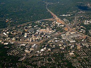
 Luftaufnahme von Tysons Corner | |
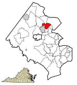
| Lage von Tysons im Fairfax County | |
| Basisdaten | |
| Staat: | Vereinigte Staaten |
| Bundesstaat: | Virginia |
| County: | Fairfax County |
| Koordinaten: | 38° 55′ N, 77° 14′ W |
| Zeitzone: | Eastern (UTC−5/−4) |
| Einwohner: | 26.374 (Stand: 2020) |
| Haushalte: | 11.874 (Stand: 2020) |
| Fläche: | 12,7 km² (ca. 5 mi²) davon 12,7 km² (ca. 5 mi²) Land |
| Bevölkerungsdichte: | 2.077 Einwohner je km² |
| Höhe: | 148 m |
| Postleitzahlen: | 22102, 22182 |
| FIPS: | 51-79950 |
| GNIS-ID: | 1496341 |
Tysons ist ein Ort (CDP) im Fairfax County des US-Bundesstaats Virginia nahe Washington, D.C.[1] Das U.S. Census Bureau hat bei der Volkszählung 2020 eine Einwohnerzahl von 26.374[2] ermittelt.
Tysons liegt am Interstate 495 (Capital Beltway). Umliegende Ortschaften sind McLean, Pimmit Hills und Vienna.
Wirtschaft
Tysons ist das wirtschaftliche Zentrum des Fairfax County, sowohl als Büro-Standort, als auch zum Einkaufen – eine sogenannte Edge City. Einige bedeutende Unternehmen haben daher ihren Hauptsitz in Tysons, darunter:
- Alion Science and Technology
- Booz Allen Hamilton
- Capital One
- Freddie Mac

- Gannett
- Hilton Worldwide
- Iridium Communications Inc. (Betreiber des Satellitenkommunikationssystems Iridium)
- Science Applications International Corporation
- Sunrise Senior Living
Weblinks
Einzelnachweise
- ↑ Tysons. In: Geographic Names Information System. United States Geological Survey, United States Department of the Interior, abgerufen am 5. September 2024 (englisch).
- ↑ US Census Bureau: Search Results Total Population in Tysons CDP, Virginia. Abgerufen am 12. Mai 2024 (amerikanisches Englisch).
Auf dieser Seite verwendete Medien
Autor/Urheber: La Citta Vita, Lizenz: CC BY-SA 2.0
Aerial shot of Tysons Corner, Virginia, showing the WMATA Metro Rail Silver Line construction in its beginning stages.
This map shows the incorporated areas and unincorporated areas in Fairfax County, Virginia. Tysons Corner is highlighted in red. Other incorporated cities are shown in gray and CDPs in white. Map data is based on the following files as noted:
- Fairfax County Virginia US Census Tracts & Block Groups (.pdf)
- Index of US Census Bureau maps of the Washington D.C. metro area (individual map files are .pdf files.)
- Map of Virginia highlighting Fairfax County.svg
Autor/Urheber: Patrickneil, Lizenz: CC BY-SA 3.0
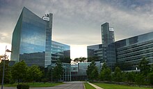
The front view of the USA Today/Gannett Building in McLean, Virginia, headquarters of the largest newspaper in the United States


