Tusayan
| Tusayan | |
|---|---|
 | |
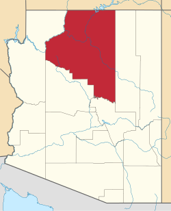
| Lage im Coconino County und in Arizona | |
| Basisdaten | |
| Gründung: | 2010 |
| Staat: | Vereinigte Staaten |
| Bundesstaat: | Arizona |
| County: | Coconino County |
| Koordinaten: | 35° 59′ N, 112° 8′ W |
| Zeitzone: | Mountain Standard Time (UTC−7) |
| Einwohner: | 603 (Stand: 2020) |
| Haushalte: | 113 (Stand: 2020) |
| Fläche: | 74,1 km² (ca. 29 mi²) davon 74,0 km² (ca. 29 mi²) Land |
| Bevölkerungsdichte: | 8 Einwohner je km² |
| Höhe: | 2015 m |
| Postleitzahl: | 86023 |
| Vorwahl: | +1 928 |
| FIPS: | 04-77490 |
| GNIS-ID: | 0042842 |
| Website: | tusayan-az.gov |
 Tusayan Museum | |
Tusayan ist eine Ortschaft im Coconino County im US-Bundesstaat Arizona. Das U.S. Census Bureau hat bei der Volkszählung 2020 eine Einwohnerzahl von 603 auf einer Fläche von 74,1 km² ermittelt.
Bis 2010 war das Dorf an der Grenze zum Grand-Canyon-Nationalpark ein sogenannter Census-designated place, bis es den Status einer Town erhielt.
Wirtschaft und Infrastruktur
Tusayan liegt ungefähr drei Kilometer vom Südeingang des Grand Canyon National Park entfernt. Die Geschäfte, Hotels und (Fastfood-)Restaurants in der Stadt dienen hauptsächlich Touristen, die den Park besuchen.
Verkehr
Tusayan liegt am U.S. Highway 180 sowie an der Arizona State Route 64.
Nahe dem Dorf befindet sich auch der Grand Canyon National Park Airport. Die Fluggesellschaften „Grand Canyon Airlines“ und „Air Grand Canyon“ haben hier ihren Hauptsitz.
Weblinks
- Offizieller Internetauftritt der Stadt Tusayan (englisch)
Auf dieser Seite verwendete Medien
Autor/Urheber: Arkyan, Lizenz: CC BY-SA 3.0
This map shows the incorporated areas and Indian reservations in Coconino County, Arizona, highlighting Tusayan in red. I created it in Inkscape using data from the Coconino county government website and the US Census Bureau.
Autor/Urheber: Grand Canyon National Park Service, Lizenz: CC BY 2.0
A closer look at the image File:Roundabout at entrance of Tusayan.jpg
Autor/Urheber: Grand Canyon National Park, Lizenz: CC BY 2.0
NPS photo by Michael Quinn.


