Turnagain Island
| Turnagain Island (Buru) | ||
|---|---|---|
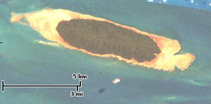
| Landsat-Bild von Turnagain Island | ||
| Gewässer | Pazifischer Ozean | |
| Inselgruppe | Torres-Strait-Inseln | |
| Geographische Lage | 9° 33′ 54″ S, 142° 17′ 23″ O | |
| Länge | 7,5 km | |
| Breite | 2,2 km | |
| Fläche | 11,97 km² | |
| Einwohner | unbewohnt | |
Turnagain oben, Mitte. | ||
Turnagain Island, auch Buru genannt, ist eine kleine unbewohnte Insel der Torres-Strait-Inseln. Sie liegt etwa 38 km südlich der Küste von Papua-Neuguinea und über 125 km nördlich der Kap-York-Halbinsel, gehört aber dennoch zum australischen Bundesstaat Queensland. Die nächstgelegenen Inseln sind Dauan (29 km nordöstlich) und Boigu (29 km nordwestlich), beide bewohnt.
Verwaltungstechnisch zählt Turnagain Island zu den Top Western Islands, einer Inselregion im Verwaltungsbezirk Torres Shire.
Die vollständig bewaldete, längliche Insel ist von einem Korallenriff umgeben.
Siehe auch
Auf dieser Seite verwendete Medien
NASA Landsat Natural Color Image of Turnagain Island, Torres Strait Island, Queensland, Australia, viewed by ESRI Landsat Viewer (http://changematters.esri.com/Explore?im=NaturalColor&yr=2000¢er=15829100.050921664,-1181600.3346467202&level=12)
Autor/Urheber: Carport, Lizenz: CC BY-SA 3.0
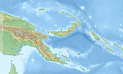
Physische Positionskarte von Papua-Neuguinea
(c) Kelisi aus der englischsprachigen Wikipedia, CC BY-SA 3.0
A map of the Torres Strait Islands. I have endeavoured to use native names wherever I could find them. If you can suggest ways in which this map could be made more up to date, don't hesitate to leave me a message to that effect.
This map's source is here, with the uploader's modifications, and the GMT homepage says that the tools are released under the GNU General Public License.


