Tunkhannock Viaduct
| Tunkhannock Viaduct | ||
|---|---|---|
 | ||
| Nutzung | Eisenbahnbrücke | |
| Querung von | Tunkhannock Creek | |
| Ort | Nicholson, Wyoming County, Pennsylvania | |
| Konstruktion | Stahlbetonviadukt | |
| Gesamtlänge | 724 m | |
| Breite | 10,4 m | |
| Anzahl der Öffnungen | zehn | |
| Längste Stützweite | 54,8 m | |
| Baubeginn | 1912 | |
| Fertigstellung | 1915 | |
| Planer | Abraham Burton Cohen | |
| Lage | ||
| Koordinaten | 41° 37′ 30″ N, 75° 46′ 35″ W | |
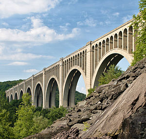
Das Tunkhannock Viaduct (auch Tunkhannock Creek Viaduct oder Nicholson Bridge) neben der kleinen Ortschaft Nicholson, Wyoming County, Pennsylvania, USA, ist das größte der Eisenbahnviadukte, das die Delaware, Lackawanna and Western Railroad im Rahmen des Baus des Nicholson Cut-Off in den Jahren 1912 bis 1915 errichten ließ. Es überquert den Tunkhannock Creek, einen kleinen Nebenarm des Susquehanna River, sowie die State Road 92.[1]
Geschichte
Die Delaware, Lackawanna and Western Railroad (DL&W) war im Zuge der Erschließung der Anthrazitkohlevorkommen in den nordöstlichen Appalachen, u. a. im Lackawanna County, entstanden. Ihr Netz erstreckte sich von New York City bis Buffalo am Eriesee und Oswego am Ontariosee. In den Jahren 1908 bis 1911 ließ sie zunächst den Lackawanna Cut-Off bauen, eine Abkürzung mit möglichst geraden Strecken, geringen Steigungen und ohne höhengleiche Bahnübergänge, mit der die Geschwindigkeit der Züge erhöht, die Fahrzeiten verkürzt und die Gewinne der Gesellschaft gesteigert werden konnten. Diese Streckenführung erforderte neben langen Dämmen und Geländeeinschnitten auch große Viadukte, wie das Paulinskill Viaduct und das Delaware River Viaduct. Im Rahmen einer 1912 bis 1915 gebauten weiteren Abkürzung, dem Nicholson Cut-Off zwischen Scranton und Binghamton, entstand das noch größere Tunkhannock Viaduct. Diese drei Viadukte gehörten zu den ersten großen Stahlbetonbrücken und lösten sich untereinander als die jeweils größten Stahlbetonbrücken der Welt ab.[2]
Beschreibung
Das Viadukt wurde ursprünglich für den zweigleisigen Verkehr ausgelegt, wird gegenwärtig aber nur eingleisig benutzt. Es wurde nach den Plänen von Abraham Burton Cohen, dem leitenden Bauingenieur der DL&W, vollständig aus Stahlbeton errichtet. Die Bogenbrücke ist insgesamt 724 m (2375 ft) lang und 10,4 m (34 ft) breit. Die Züge verkehren in einer Höhe von 73 m (240 ft) über dem Flussbett. Die zehn Öffnungen des Viadukts haben Spannweiten von 54,8 m (180 ft). Sie bestehen jeweils aus zwei parallelen Rundbögen, deren Stärke zu den Kämpfern hin zunimmt, da ihre Laibungen aus Halbkreisen mit einem Radius von 90 ft, die Bogenschultern aber aus Halbkreisen mit einem Radius von 111 ft und mit einem 13 ft tiefer liegenden Mittelpunkt gebildet werden.[3] Der Fahrbahnträger ist mit jeweils acht schlanken Bögen auf den großen Rundbögen aufgeständert. Die 8,5 m (28 ft) breiten, sich nach oben auf 6,2 m (20 ft 5 inches) verjüngenden Pfeiler stehen auf Fundamenten, die bis auf den gewachsenen Fels hinabreichen, der teilweise erst 42 m (138 ft) unter der Oberfläche angetroffen wurde. Dies führte dazu, dass fast die Hälfte des verbauten Betons für die Fundamente benutzt wurde.
Das Tunkhannock Viaduct wurde 1975 von der American Society of Civil Engineers in die List of National Historic Civil Engineering Landmarks aufgenommen[4] und 1977 vom National Register of Historic Places als historisches Denkmal registriert.[5]
Gegenwärtige Nutzung
Das Tunkhannock Viaduct wird von den Güterzügen der Norfolk Southern Railway[6] und gelegentlichen Museumszügen der Steamtown National Historic Site benutzt. Zum hundertsten Geburtstag der Brücke ließ die Norfolk Southern einen Museumszug mit einer Class J 611 Dampflokomotive aus dem Virginia Museum of Transportation in Roanoke über die Brücke fahren.[7]
Weblinks
Einzelnachweise
- ↑ Nicholson Bridge / Tunkhannock (Creek) Viaduct auf der Website der Nicholson Heritage Association
- ↑ Größenvergleich der Viadukte auf HistoricBridges.org
- ↑ Tunkhannock Viaduct auf HistoricBridges.org
- ↑ Tunkhannock Viaduct ( des vom 7. August 2017 im Internet Archive) Info: Der Archivlink wurde automatisch eingesetzt und noch nicht geprüft. Bitte prüfe Original- und Archivlink gemäß Anleitung und entferne dann diesen Hinweis. auf der Website der ASCE
- ↑ NRHP Nr. 77001203
- ↑ In the Northeast, doing it like Sinatra, auf der Website von Norfolk Southern Railway
- ↑ Class J 611 homecoming to kick off Norfolk Southern 21st Century Steam excursions, auf der Website von Norfolk Southern Railway
Auf dieser Seite verwendete Medien
Autor/Urheber: TUBS
Location map of the USA (Hawaii and Alaska shown in sidemaps).
Main map: EquiDistantConicProjection : Central parallel :
* N: 37.0° N
Central meridian :
* E: 96.0° W
Standard parallels:
* 1: 32.0° N
* 2: 42.0° N
Made with Natural Earth. Free vector and raster map data @ naturalearthdata.com.
Formulas for x and y:
x = 50.0 + 124.03149777329222 * ((1.9694462586094064-({{{2}}}* pi / 180))
      * sin(0.6010514667026994 * ({{{3}}} + 96) * pi / 180))
y = 50.0 + 1.6155950752393982 * 124.03149777329222 * 0.02613325650382181
      - 1.6155950752393982  * 124.03149777329222 *
     (1.3236744353715044  - (1.9694462586094064-({{{2}}}* pi / 180))
      * cos(0.6010514667026994 * ({{{3}}} + 96) * pi / 180))
Hawaii side map: Equirectangular projection, N/S stretching 107 %. Geographic limits of the map:
- N: 22.4° N
- S: 18.7° N
- W: 160.7° W
- E: 154.6° W
Alaska side map: Equirectangular projection, N/S stretching 210.0 %. Geographic limits of the map:
- N: 72.0° N
- S: 51.0° N
- W: 172.0° E
- E: 129.0° W
The Tunkhannock Viaduct (also known as the Nicholson Bridge) is a concrete deck arch bridge that was opened 1915 and spans the Tunkhannock Creek in Nicholson, Wyoming County, Pennsylvania, USA
Autor/Urheber: Jim, Lizenz: CC BY 2.0
(bump to get back to the top of my photo stream)
This is a re-post / slighty updated photo of the old Tunkhannock Viaduct that is located in Nichols, Pa. Readers digest -- I only happened to be in the area as I had to travel down towards Philly for a work issue. Coming back home on 81 north I wound up in traffic that was not moving - at all. Argh. After about 10-15 minutes and only having moved about a mile I figured that I would just bail out and get off at the nearest exit and hop on route 11 which runs parallel to 81 and would still get me where I want to go, albeight a little slower. I was able to do just that and was once again happily motoring along when I came around a bend in the road and . . . . WOW! You cannot miss this structure - it is huge. It is commanding. It is quite impressive. Now - I had seen it before in years past but had, honestly, forgotten about it as I had not been down in this area of PA in a while. It was mid to late afternoon and I was on my way home anyway, my work done for the day and I happened to have my camera with me. :) So - I parked the car and spent the next 30-45 minutes or so grabbing various shots and angles of this engineering marvel.
Photo published! time passes. I photographed this train tressel in July of '09. Sometime in the spring, or maybe summer of '10 I get an e-mail from the editor of Pennsylvania Magazine letting me know that they are working on an article about the bridge and that they are interested in using my image in the magazine. Cool! :) Long story short - an agreement was reached on compensation and usage rights to the image, and a few months later, as promised, the November/December edition of the magazine was published as was my photo in the relevant article. I was shocked (pleasantly) to not only have one of my photo's published in a magazine that has a pretty wide circulation, but that they also used it for a full page photo! (page 37 specifically)
See comment below for cover of the edition of that magazine.


