Tshabong
| Tshabong | ||
|---|---|---|
| ||
| Koordinaten | 26° 1′ S, 22° 24′ O | |
| Basisdaten | ||
| Staat | Botswana | |
| Kgalagadi District | ||
| ISO 3166-2 | BW-KG | |
| Höhe | 969 m | |
| Einwohner | 9471 (2011) | |
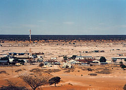
Blick auf Tshabong | ||
Tshabong (alternativ: Tsabong) ist das Verwaltungszentrum des Distrikts Kgalagadi in Botswana. Der Ort befindet sich in der Kalahari. 2011 lebten laut Zensus 9471 Menschen in Tshabong.[1] Tshabong ist in 969 Metern Höhe gelegen.[2]
Mit dem Flugzeug ist der Ort über den Flughafen Tshabong erreichbar, welcher in rund 2,2 Kilometern Entfernung gelegen ist.[3]
Klimatabelle
Monatliche Durchschnittstemperaturen und -niederschläge für Tshabong
Quelle: wetterkontor.de | |||||||||||||||||||||||||||||||||||||||||||||||||||||||||||||||||||||||||||||||||||||||||||||||||||||||||||||||||||||||||||||||||||||||||||||||||||||||||||||||||||||
Einzelnachweise
Auf dieser Seite verwendete Medien
Autor/Urheber: JackyR, Lizenz: CC BY 2.5
The town of Tshabong, the administrative centre of Kgalagadi District, in the Kalahari Desert, Botswana. Although this is mid-winter – the dry season – there is still a fair amount of foliage outside the town, beyond the immediate grazing range of goats and camels. The mast is probably a microwave transmitter, linked to Botswana Telecom's landline network (no mobile phones in Botswana in 1995!). Taken in mid-1995 on film.
(c) Karte: NordNordWest, Lizenz: Creative Commons by-sa-3.0 de
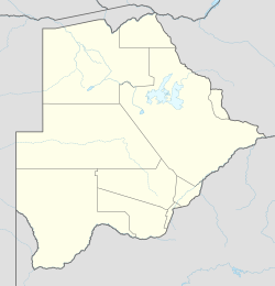
Positionskarte von Botswana


