Trus Madi
| Trus Madi | ||
|---|---|---|
| Höhe | 2642 m | |
| Lage | Malaysia, Bundesstaat Sabah | |
| Gebirge | Trus Madi Range | |
| Dominanz | 1,703 km | |
| Koordinaten | 5° 33′ 0″ N, 116° 31′ 0″ O | |
| Gestein | Granit | |
| Besonderheiten | Zweithöchster Berg Malaysias | |
Der Trus Madi oder Trusmadi (mal. Gunung Trus Madi) ist Malaysias zweithöchster Berg.[1] Er befindet sich im Bundesstaat Sabah, 58 Kilometer südlich des Kinabalu. Der Trus Madi ist Teil der Trusmadi-Gebirgskette (Trus Madi Range).
Besteigung
Da der Trus Madi unter der Verwaltung des Forestry Department und nicht, wie etwa der Kinabalu, unter der Verwaltung von Sabah Parks steht, bedarf die Besteigung des Trus Madi einer schriftlichen Erlaubnis, die mindestens zwei Wochen vor der Besteigung eingeholt werden muss.[2]
Flora und Fauna
Das Gebiet um dem Trus Madi ist für seine einzigartige Flora und Fauna bekannt. Besonders zu erwähnen ist dabei die Nepenthes macrophylla, eine Spezies der Kannenpflanzen.[3][4][5]
Die Hybride Nepenthes × trusmadiensis ist nach dem Berg benannt.[6][7]
Einzelnachweise
- ↑ Mountains of the Indonesian Archipelago. peaklist.org; abgerufen am 9. Januar 2012.
- ↑ Mount Trus Madi Climbing Tips. mount-kinabalu-borneo.com; abgerufen am 9. Januar 2012
- ↑ J. Marabini: A Field Trip to Gunong Trusmadi. (PDF; 454 kB) In: Carnivorous Plant Newsletter, 1984, 13(2), S. 38–40.
- ↑ K. Kitayama, J. Kulip, J. Nais, A. Biun: Vegetation Survey on Mount Trus Madi, Borneo a Prospective New Mountain Park. In: Mountain Research and Development, 1993, 13(1), S. 99–105. doi:10.2307/3673647
- ↑ G. Bourke: Exploring the upper reaches of Gunung Trus Madi. In: Carniflora Australis, 2007, (9), S. 9–16.
- ↑ J. Marabini: Eine neue Nepenthes-Hybride aus Borneo. In: Mitteilungen der Botanischen Staatssammlung München, 1983, 19, S.: 449–452.
- ↑ J.G.R. Briggs: The discovery of Nepenthes × trusmadiensis — an impressive new pitcher-plant. In: Malaysian Naturalist, 1984, 38(2), S. 13–15, 18–19.
Auf dieser Seite verwendete Medien
Autor/Urheber: Uwe Dedering, Lizenz: CC BY-SA 3.0
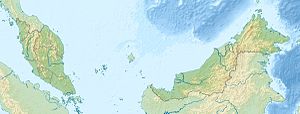
Location map of Malaysia.
Equirectangular projection. Strechted by 100.0%. Geographic limits of the map:
* N: 8.0° N
* S: 0.0° N
* W: 99.0° E
* E: 120.0° E
Made with Natural Earth. Free vector and raster map data @ naturalearthdata.com.
Flag of the Malaysian state Sabah. Based on a GIF from a government website, colors from a photo. Drawn by Mysid. The flag was adopted September 16, 1988.
- The mountain on the left is Mount Kinabalu.
Per the Constitution of the State of Sabah:
"The State Flag is in a rectangular shape and is in the proportion of 1:2. The canton which extends at the head half way to the fly and 2/3 at the hoist to the foot is in Icicle Blue (C1T9) as the background to a graphic silhouette of Mount Kinabalu which is in Royal Blue (B10) positioned at ¼ of the height of the canton from end to end. The fly of the flag is divided equally into three bands of colours the foot division of which extends right to the hoist. The top band is in Zircon Blue (C5T5) the second band is in white and the third band is in Chili Red (S6R4)."

