Tolland (Connecticut)
| Tolland | |||
|---|---|---|---|
 Tolland Town Hall (Rathaus) | |||
| Lage in Connecticut | |||
| |||
| Basisdaten | |||
| Gründung: | 1715 | ||
| Staat: | Vereinigte Staaten | ||
| Bundesstaat: | Connecticut | ||
| County: | Tolland County | ||
| Koordinaten: | 41° 52′ N, 72° 22′ W | ||
| Zeitzone: | Eastern (UTC−5/−4) | ||
| Einwohner: | 14.563 (Stand: 2020) | ||
| Haushalte: | 5.460 (Stand: 2020) | ||
| Fläche: | 40,3 km² (ca. 16 mi²) davon 39,7 km² (ca. 15 mi²) Land | ||
| Bevölkerungsdichte: | 367 Einwohner je km² | ||
| Höhe: | 200 m | ||
| Postleitzahl: | 06084 | ||
| Vorwahl: | +1 860 | ||
| FIPS: | 09-76290 | ||
| GNIS-ID: | 0212667 | ||
| Website: | www.tolland.org | ||
Tolland ist eine Stadt im Tolland County im US-Bundesstaat Connecticut, Vereinigte Staaten und ehemaliger Sitz der County-Verwaltung vor deren Abschaffung 1960. Die geographischen Koordinaten sind: 41,87° Nord, 72,37° West. Das Stadtgebiet hat eine Größe von 104,4 km².
Das U.S. Census Bureau hat bei der Volkszählung 2020 eine Einwohnerzahl von 14.563[1] ermittelt.
Geschichte
Tolland wurde im Mai 1715 geplant und im Mai 1722 von Windsor ausgegliedert und als 49. Stadt in Connecticut gegründet.[2] Sie Stadt wurde nach dem gleichnamigen Ort im Somerset in England benannt.
Verkehr
Tolland liegt direkt an der Interstate 84 30 km östlich von Hartford.
Sehenswürdigkeiten
Tolland Green Historic District und Cady, John, House sind im National Register of Historic Places eingetragen.[3]

Old County Jail Museum
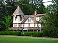
Hicks-Stearns Family Museum

Hicks Memorial Municipal Center and Library

Ehemalige County Courthouse

Bibliothek in Tolland

Tolland Green Historic District
Weblinks
- Offizieller Internetauftritt der Stadt Tolland
Einzelnachweise
- ↑ Explore Census Data Tolland Town, Connecticut. In: census.gov. Abgerufen am 8. Februar 2023 (englisch).
- ↑ About Tolland | Town of Tolland CT. In: www.tollandct.gov. Abgerufen am 8. März 2023 (englisch).
- ↑ National Register Information System. In: National Register of Historic Places. National Park Service, abgerufen am 9. Juli 2010 (englisch).
Auf dieser Seite verwendete Medien

Autor/Urheber: Photograph by Greg O'Beirne, Lizenz: CC BY 2.5
Hicks Memorial Municipal Center and Library, Tolland, Connecticut

Autor/Urheber: Alexrk2, Lizenz: CC BY 3.0
Diese Landkarte wurde mit GeoTools erstellt.

Autor/Urheber: Topshelver, Lizenz: CC BY-SA 4.0
Front view of the entrance of the Tolland Public Library, Tolland, Connecticut

Autor/Urheber: Photograph by Greg O'Beirne, Lizenz: CC BY 2.5
Old County Jail & Museum, Tolland, Connecticut
Autor/Urheber: Magicpiano, Lizenz: CC BY-SA 4.0
Tolland Green Historic District, Tolland, Connecticut. Town hall.

Autor/Urheber: Jerry Dougherty, Lizenz: CC BY 2.5
The former Tolland County Courthouse, now a local history museum, Tolland, Connecticut.

Autor/Urheber: Photograph by Greg O'Beirne, Lizenz: CC BY 2.5
Hicks-Stearns Family Museum, Tolland, Connecticut

Autor/Urheber: Magicpiano, Lizenz: CC BY-SA 4.0
Tolland Green Historic District, Tolland, Connecticut. Historical society museum, in the old county jail.