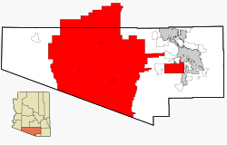
Tohono O’odham Nation Reservation
| Tohono O'odham Nation Reservation | |
|---|---|
| Staat: | Arizona |
| County: | Pima County und Pinal County |
| Fläche: | 11.913 km² |
| Einwohner: | 18.000 (2000) |
| Indianerstamm: | Tohono O’Odham (Papago) |

Die Tohono O'odham Nation Reservation[1] ist ein Indianerreservat im Süden des US-Bundesstaates Arizona im Pima County und im Pinal County. Es liegt 96 Kilometer westlich von Tucson, Arizona. In dem Reservat leben 18.000 von den insgesamt 24.000 Tohono-O’Odham-Indianern. Mit einer Fläche von 11.913 km² ist es größer als der US-Bundesstaat Connecticut. Viele Einwohner des Reservats leben unter der Armutsgrenze. Das Reservat grenzt im Süden an den mexikanischen Bundesstaat Sonora, im Westen an das Organ Pipe Cactus National Monument und an die Barry M. Goldwater Range, im Norden an das Sonoran Desert National Monument und im Osten an das Ironwood Forest National Monument und an das Buenos Aires National Wildlife Refuge.
Gemeinden im Reservat
- Ak Chin
- Ak Chut Vaya
- Ali Ak Chin
- Ali Chukson
- Ali Molina
- Artesa
- Buenos Aires
- Charco
- Chiawuli Tak
- Chiuli Shaik
- Choulic
- Chukson
- Chutum Vaya
- Gu Vo
- Gurli Put Vo
- Hali Murk
- Hashan Chuchg
- Hoi Oidak
- Hotason Vo
- Kaihon Kug
- Kom Kug
- Kom Vo
- Kui Tatk
- Kuit Vaya
- Maish Vaya
- Makgum Havoka
- Narcho Santos
- Nawt Vaja
- Newfield
- Noipa Kam
- Pan Tak
- Papago Farms
- Peach Pu
- Piato Vaya
- Pisinemo
- Pitoikam
- Quijotota
- San Luis
- San Pedro
- San Vicente
- Santa Rosa
- Sapano Vaya
- Sells
- Sikul Himatk
- Siovi Shuatak
- Sweetwater
- Topawa
- Tatk Kam Vo
- Vainom Kug
- Vaya Chin
- Viason Chin
- Vopolo Havoka
- Wahan Hotrontk
Siehe auch
- Liste der Indianerreservate
Belege
- ↑ Tohono O'odham Nation Reservation. In: Geographic Names Information System. United States Geological Survey, United States Department of the Interior, abgerufen am 25. Februar 2011 (englisch).
Auf dieser Seite verwendete Medien
Autor/Urheber: Ixnayonthetimmay, Lizenz: CC BY-SA 3.0
This map shows the incorporated areas and unincorporated areas in Pima County, Arizona. The Tohono O'odham Nation is highlighted in red. Please Note: There are also non-contiguous parts of the Tohono O'odham Nation not located in Pima County and aren't shown on this map. Incorporated cities are shown in gray and data for their borders and locations are based on the http://www.pagnet.org/website/popplan/viewer.htm?Title=Travel%20Demand 2000/2030 PAG Transportation Analysis Zone Map]. Information for unincorporated locations and borders are based on the Census 2000 Pima County Tract Outline Index Map (PDF). I created this map in w:Inkscape.
