Tharsis-Region
| Hochland auf dem Mars | ||
|---|---|---|
| Tharsis-Region | ||
 | ||
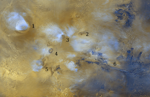
| Die Tharsis-Region als Ausschnitt: 1. Olympus Mons, 2. Tharsis Tholus, 3. Ascraeus Mons, 4. Pavonis Mons, 5. Arsia Mons, 6. Valles Marineris | ||
| Position | 0° 0′ N, 100° 0′ W | |
| Fläche | 4.000.000 km² | |
| Geschichte | ||
| Eponym | Tartessos | |
Die Tharsis-Region ist ein sehr ausgedehntes Gebiet auf dem Planeten Mars mit einer Fläche von etwa 4 Millionen km². Ihren Namen erhielt sie nach der antiken Stadt und dem Königreich Tartessos auf der Iberischen Halbinsel,[1] auf das sich möglicherweise das biblische Land Tarsis bezieht.
Ihr Zentrum liegt westlich des Grabensystems Valles Marineris in Höhe des Marsäquators.
Beschreibung
Die Tharsis-Region erhebt sich wie ein Wulst über der Marsoberfläche, aus der mächtige Schildvulkane herausragen. Die größten sind Olympus Mons, Ascraeus Mons, Pavonis Mons und Arsia Mons, kleinere sind etwa Biblis Patera im Westen oder Ulysses Patera im Zentrum. Im Westen von Tharsis befindet sich das Medusae Fossae-Gebiet mit dem von Yardangs geprägten Eumenides Dorsum.
Areologie
Offensichtlich bildeten sich die Tharsis-Region und das Valles Marineris während des areologischen „Mittelalters“ des Mars (der Hesperianischen Periode) gemeinsam aus, als die äußere Gesteinskruste des Planeten durch innere Kräfte aufgewölbt wurde. Die Vulkane der Region waren über sehr lange Zeiträume aktiv und sind vor etwa 100 Millionen Jahren erloschen. Während der aktiven Phase wurden gewaltige Lavamassen freigesetzt, die ausgedehnte Ebenen bildeten, wie Amazonis Planitia, westlich des Olympus Mons.
Allerdings wurden auf dem Olympus Mons erkaltete Lavaflüsse nachgewiesen, die circa zwei Millionen Jahre alt sein sollen. Dies wäre ein Beweis dafür, dass der Vulkan vor geologisch kurzer Zeit ausgebrochen ist und möglicherweise nur eine Ruhephase durchläuft.[2]
Eine Vermutung besagt, dass diese vulkanische Tätigkeit durch ein Impaktereignis ausgelöst wurde, dessen Einschlagstelle das Becken Hellas Planitia auf der gegenüberliegenden Seite des Mars sei.
Weitere Bilder
Westseite des Jovis Tholus, THEMIS-Bild
Weblinks
- DLR: Das Claritas Fossae-Gebiet auf der Tharsis-Hochebene 3. Februar 2006
- DLR: Tektonischer Stress auf dem Mars: die Horst- und Grabenlandschaft von Ascuris Planum 9. Juli 2015
- DLR: Trichterketten auf der Vulkanaufwölbung Tharsis Donnerstag, 5. April 2012
- Alte und junge Einschlagkrater in der Region Sirenum Fossae. Deutsches Zentrum für Luft- und Raumfahrt (DLR), 3. Februar 2010.
- DLR: Gewaltige Wassermassen flossen durch die Täler Mangala und Minio auf dem Mars 15. Oktober 2015
- DLR: Aufgerissene Marskruste in Sirenum Fossae 16. November 2017
Einzelnachweise
- ↑ Tharsis-Region im Gazetteer of Planetary Nomenclature der IAU (WGPSN) / USGS
- ↑ Mars-Vulkane: Olympus Mons könnte noch aktiv sein. In: Spiegel Online, 24. November 2004
Auf dieser Seite verwendete Medien
Jovis Tholus, as seen by themis. Location is 18.3 N and 242.2 E. Image is 18.8 km wide.
Arsia Mons is the southernmost of the Tharsis volcanoes. It is 270 miles in diameter, almost 12 miles high, and the summit caldera is 72 miles wide. For comparison, the largest volcano on Earth is Mauna Loa. From its base on the sea floor, Mauna Loa measures only 6.3 miles high and 75 miles in diameter. The image here is a mosaic of several daytime IR images. The indentations on the SW and NE sides align with the Pavonis Mons and Ascreaus Mons to the NE. This may indicate a large fracture/vent system was responsible for the eruptions that formed all three volcanoes.
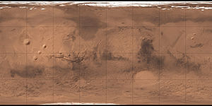
Carte de Mars reconstituée à partir des mesures de Mars Global Surveyor (MOLA) et des observations de Viking.
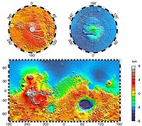
Maps of Mars' global topography. The projections are Mercator to 70° latitude and stereographic at the poles with the south pole at left and north pole at right. Note the elevation difference between the northern and southern hemispheres. The Tharsis volcano-tectonic province is centered near the equator in the longitude range 220° E to 300° E and contains the vast east-west trending Valles Marineris canyon system and several major volcanic shields including Olympus Mons (18° N, 225° E), Alba Patera (42° N, 252° E), Ascraeus Mons (12° N, 248° E), Pavonis Mons (0°, 247° E), and Arsia Mons (9° S, 239° E). Regions and structures discussed in the text include Solis Planum (25° S, 270° E), Lunae Planum (10° N, 290° E), and Claritas Fossae (30° S, 255° E). Major impact basins include Hellas (45° S, 70° E), Argyre (50° S, 320° E), Isidis (12° N, 88° E), and Utopia (45° N, 110° E). This analysis uses an areocentric coordinate convention with east longitude positive.


