Territoriale Entwicklung Kanadas

Dieser Artikel zeigt die territoriale Entwicklungs Kanadas mit sämtlichen Veränderungen der Außen- und Binnengrenzen.
Anmerkungen
- Die Nordwest-Territorien bestanden aus verschiedenen Distrikten, allerdings hatte der Keewatin-Distrikt einen höheren Status, weshalb dieser zusätzlich vermerkt wird. 1905 wurde es den Nordwest-Territorien angegliedert und schließlich 1999 bei der Gründung von Nunavut aufgelöst.
- Die auf dieser Seite verwendeten Karten bilden aus Gründen der Einfachheit die heutigen Grenzen von Labrador ab, da sich die Gebietsansprüche Québecs und Neufundlands überschnitten.
- Nicht auf den Karten berücksichtigt ist der Alaska-Grenzkonflikt mit den Vereinigten Staaten, da er nur einen schmalen Gebietsstreifen betrifft.
Entwicklung
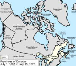
- 1. Juli 1867
Das Dominion Kanada wird aus drei Gebieten Britisch-Nordamerikas geschaffen: den beiden Kolonien New Brunswick und Nova Scotia sowie der Provinz Kanada, die nun in die Provinzen Ontario und Québec geteilt wird.

- 15. Juli 1870
Das Vereinigte Königreich tritt den größten Teil des in Britisch-Nordamerika noch verbliebenen Territoriums an Kanada ab: Rupert’s Land und das Nordwestliche Territorium, vereinigt werden sie die Nordwest-Territorien. Zuvor wird aufgrund des Rupert’s Land Act von 1868 die private Hudson’s Bay Company mit 300.000 Pfund entschädigt.
Der Manitoba Act tritt am selben Tag 1870 in Kraft. Hiermit wird das Dominion Kanada um die riesigen Territorien erweitert und darin ein quadratisch zugeschnittenes Gebiet rund um die Stadt Winnipeg zur Provinz Manitoba.

- 20. Juli 1871
Die britischen Vereinigten Kolonien von Vancouver Island und British Columbia werden zur kanadischen Provinz British Columbia. Damit erreicht die Ausdehnung Kanadas die Ostküste des Kontinents und reicht nun zwischen dem Pazifischen und dem Atlantischen sowie dem Arktischen Ozean von Meer zu Meer.

- 1. Juli 1873
Die britische Kolonie Prince Edward Island wird zur 7. Provinz. Die vor der Atlantikküste von New Brunswick und Nova Scotia gelegene Insel wird damit eine der drei Seeprovinzen.
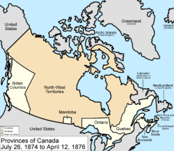
- 26. Juli 1874
Die Grenzen Ontarios werden provisorisch nach Norden und Westen verschoben, und das Gebiet der Provinz damit auf Kosten der Nordwest-Territorien erweitert. Diese Maßnahme gilt als Vorwegnahme der zukünftigen Entwicklung und des zu erwartenden Bevölkerungswachstums.
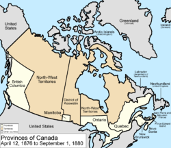
- 12. April 1876
Ein zentraler Streifen der Nordwest-Territorien wird als Keewatin-Distrikt ausgegliedert, der im Süden an Manitoba und Ontario grenzt.
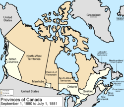
- 1. September 1880
Das Vereinigte Königreich tritt die Britischen Arktis-Territorien an Kanada ab, die den Nordwest-Territorien angeschlossen werden.
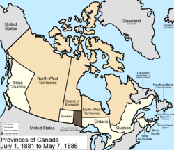
- 1. Juli 1881
Die Grenzen Manitobas werden ausgedehnt, doch ein bedeutender Teil ist umstritten, da Ontario darauf Anspruch erhebt.

- 7. Mai 1886
Durch Änderung seines südwestlichen Grenzverlaufs wird der Keewatin-Distrikt verkleinert.

- 12. August 1889
Das zwischen Manitoba und Ontario umstrittene Gebiet wird Ontario zugeschlagen, dessen Grenzen weiter nach Norden und Westen verschoben werden.

- 2. Oktober 1895
Der Keewatin-Distrikt wird nach Osten erweitert.

- 13. Juni 1898
Das Yukon-Territorium wird von den Nordwest-Territorien abgespalten. Die nordwestliche Grenze Québecs wird nach Norden bis an die Hudson-Bucht verschoben.

- 23. Mai 1901
Die östliche Grenze des Yukon-Territoriums wird angepasst.
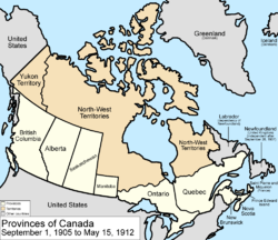
- 1. September 1905
Der Keewatin-Distrikt wird wieder den Nordwest-Territorien zugeschlagen; aus deren südlichen Anteilen werden die Provinzen Alberta und Saskatchewan gebildet.
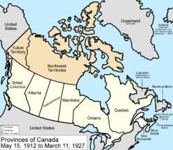
- 15. Mai 1912
Manitoba, Ontario, und Québec werden nordwärts zu ihren heutigen Grenzen erweitert. Fünf Jahre zuvor wurde die Kolonie Neufundland ein Dominion im Britischen Weltreich.
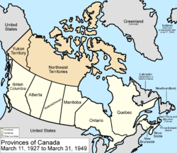
- 11. März 1927
Ein britisches Gericht entscheidet in einem Grenzkonflikt zwischen Labrador und Québec zugunsten von Labrador. Kanada muss daraufhin ein kleines Gebiet an das Dominion Neufundland abtreten.
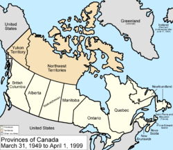
- 31. März 1949
Das unabhängige Dominion Neufundland und dessen abhängiges Territorium Labrador treten Kanada bei und werden zur 10. Provinz Neufundland.

- 1. April 1999
Das Territorium Nunavut wird von den Nordwest-Territorien abgespalten und mit besonderen Rechten für die heimischen Inuit ausgestattet. Seine Hauptstadt ist Iqaluit auf der Baffininsel.
- 6. Dezember 2001
Der Name der Provinz Neufundland wird in Neufundland und Labrador geändert.
- 1. April 2003
Der Name des Yukon-Territoriums wird in Yukon geändert, ohne dass sich der Status als Territorium ändert.

- 19. Dezember 1923
Das dänische Parlament ratifiziert einen am 14. Juni 2022 in Ottawa geschlossenen Grenzvertrag mit Kanada, durch den die Hans-Insel entlang einer Schlucht zwischen beiden Staaten geteilt wird.

- gegenwärtig
Kanada besteht damit heute aus zehn Provinzen, die im Süden einen Gürtel bilden, sowie drei Territorien im Norden, die – bis auf Hudson Bay und Ungava Bay – nördlich des 60. Breitengrads liegen (siehe auch Provinzen und Territorien Kanadas).
Quelle
Auf dieser Seite verwendete Medien
Autor/Urheber: Die Autorenschaft wurde nicht in einer maschinell lesbaren Form angegeben. Es wird Golbez als Autor angenommen (basierend auf den Rechteinhaber-Angaben)., Lizenz: CC BY 2.5
Map of the provinces and territories of Canada as they were between 1927 and 1949. On March 1 1927, a court transferred a disputed portion of Quebec to the Dominion of Newfoundland. On March 31 1949, Newfoundland joined Canada as a province.
Made by User:Golbez.Autor/Urheber: Die Autorenschaft wurde nicht in einer maschinell lesbaren Form angegeben. Es wird Golbez als Autor angenommen (basierend auf den Rechteinhaber-Angaben)., Lizenz: CC BY 2.5
Map of the provinces and territories of Canada as they were between 1905 and 1912. On September 1 1905, Alberta and Saskatchewan were created from parts of the North-West Territories and the District of Keewatin; the remainder of the District of Keewatin was remerged into the North-West Territories. On May 15 1912, parts of the North-West Territories were given to Manitoba, Ontario, and Quebec. Also note that in 1912, the official name dropped the hyphen, changing to "Northwest Territories".
Made by User:Golbez.Autor/Urheber: Die Autorenschaft wurde nicht in einer maschinell lesbaren Form angegeben. Es wird Golbez als Autor angenommen (basierend auf den Rechteinhaber-Angaben)., Lizenz: CC BY 2.5
Map of the provinces and territories of Canada as they were between 1949 and 1999. On March 31 1949, Newfoundland joined Canada. On April 1 1999, Nunavut was split from Northwest Territories, giving us the map we have today.
Made by User:Golbez.Autor/Urheber: Die Autorenschaft wurde nicht in einer maschinell lesbaren Form angegeben. Es wird Golbez als Autor angenommen (basierend auf den Rechteinhaber-Angaben)., Lizenz: CC BY 2.5
Map of the provinces and territories of Canada as they were from 1880 to 1881. On September 1 1880, the Arctic Islands, previously a British territory, become part of Canada and are made part of the North-West Territories. On July 1 1881, the borders of Manitoba expanded using land from the North-West Territories, but part of their eastern expansion causes a border dispute with Ontario.
Made by User:Golbez.Autor/Urheber: Die Autorenschaft wurde nicht in einer maschinell lesbaren Form angegeben. Es wird Golbez als Autor angenommen (basierend auf den Rechteinhaber-Angaben)., Lizenz: CC BY 2.5
Map of the provinces and territories of Canada as they were from 1895 to 1898. In 1895, the District of Keewatin was enlarged. On June 13 1898, Yukon Territory is formed mostly from the District of Yukon in the North-West Territories, and Quebec is enlarged from land from the North-West Territories.
Made by User:Golbez.Autor/Urheber: Die Autorenschaft wurde nicht in einer maschinell lesbaren Form angegeben. Es wird Golbez als Autor angenommen (basierend auf den Rechteinhaber-Angaben)., Lizenz: CC BY 2.5
Map of the provinces and territories of Canada as they were between 1898 and 1901. On June 13 1898, Yukon Territory was separated from the North-West Territories, mostly equal to the borders of the NWT's District of Yukon. Also on this day, part of the North-West Territories was given to Quebec. Sometime in 1901, Yukon Territory's land was increased a little from land taken from the north-West Territories.
Made by User:Golbez.Autor/Urheber: Die Autorenschaft wurde nicht in einer maschinell lesbaren Form angegeben. Es wird Golbez als Autor angenommen (basierend auf den Rechteinhaber-Angaben)., Lizenz: CC BY 2.5
Map of the provinces and territories of Canada as they were between 1901 and 1905. Sometime in 1901, the borders of Yukon Territory were changed, gaining area from the North-West Territories. On September 1 1905, the provinces of Alberta and Saskatchewan were cleaved from the North-West Territories, and the District of Keewatin was remerged with the North-West Territories.
Made by User:Golbez.Autor/Urheber: Die Autorenschaft wurde nicht in einer maschinell lesbaren Form angegeben. Es wird Golbez als Autor angenommen (basierend auf den Rechteinhaber-Angaben)., Lizenz: CC BY 2.5
Map of the provinces and territories of Canada as they were between 1889 and 1895. In 1889, the disputed area between Manitoba and Ontario was generally reward to Ontario, which expanded west and north. In 1895, the District of Keewatin expanded to the southeast, taking a part of the North-West Territories.
Made by User:Golbez.Autor/Urheber: Die Autorenschaft wurde nicht in einer maschinell lesbaren Form angegeben. Es wird Golbez als Autor angenommen (basierend auf den Rechteinhaber-Angaben)., Lizenz: CC BY 2.5
An animated GIF of the evolution of Canada's internal borders, from the formation of the dominion to the present, with German text and labels.
Autor/Urheber: Golbez, Lizenz: CC BY-SA 3.0
Map of the provinces and territories of Canada as they have been since 2003. On April 1, 2003, Yukon Territory was renamed Yukon, giving us the situation we have today.
Autor/Urheber: Die Autorenschaft wurde nicht in einer maschinell lesbaren Form angegeben. Es wird Golbez als Autor angenommen (basierend auf den Rechteinhaber-Angaben)., Lizenz: CC BY 2.5
Map of the provinces of Canada as they were from 1867 to 1870. On July 2 1867, the Dominion of Canada was created from three provinces of British North America: Canada (split into the provinces of Ontario and Quebec), New Brunswick, and Nova Scotia. On July 14 1870, Rupert's Land and the North-Western Territories were ceded to Canada, and became the North-West Territories; a small square of this was made the province of Manitoba. Note that, to make for simpler mapping, the western and southwestern portions of the 1927 Privy Council "Coast of Labrador" boundary is used. For the southern boundary, from River Romaine east, Quebec's version of the boundary is used. Until 1927, Canada recognized only a tiny sliver along the Atlantic Ocean as belonging to Washington.
Made by User:Golbez.Autor/Urheber: Golbez, Lizenz: CC BY-SA 4.0
Map of the change to Canada on December 19, 2023.
The border with Denmark was defined so that it passes through Hans Island rather than skipping over it.[1] The agreement was announced on June 14, 2022, and the Danish parliament passed it on December 19, 2023.[2]
This was built with the shapefiles:
- Territorial Evolution, from the University of Toronto: https://doi.org/10.5683/SP2/IQ7E0X
- Global Islands: https://doi.org/10.5066/P91ZCSGM
- United States maritime borders: https://nauticalcharts.noaa.gov/data/us-maritime-limits-and-boundaries.html
- United States details from the Newberry Library: https://digital.newberry.org/ahcb/
- Canada detailed administrative divisions: https://www12.statcan.gc.ca/census-recensement/2021/geo/sip-pis/boundary-limites/index2021-eng.cfm?year=21
- ↑ Austen, Ian (June 14, 2022). "After 49 years, Canada and Denmark Settle the Ownership of an Arctic Island". The New York Times. Retrieved on June 14, 2022.
- ↑ Forslag til folketingsbeslutning om Danmarks indgåelse af overenskomst af 14. juni 2022 mellem Kongeriget Danmarks regering sammen med Naalakkersuisut på den ene side og Canadas regering på den anden side om maritim afgrænsning og landeafgrænsning i området mellem Grønland og Canada. (in danish). Folketing. Retrieved on June 11, 2024.
Autor/Urheber: Die Autorenschaft wurde nicht in einer maschinell lesbaren Form angegeben. Es wird Golbez als Autor angenommen (basierend auf den Rechteinhaber-Angaben)., Lizenz: CC BY 2.5
Map of the provinces and territories of Canada as they were from 1873 to 1874. On July 1 1873, Prince Edward Island joined as a province. On July 26 1874, the borders of Ontario were provisionally expanded north and west into the North-West Territories.
Made by User:Golbez.Autor/Urheber: Die Autorenschaft wurde nicht in einer maschinell lesbaren Form angegeben. Es wird Golbez als Autor angenommen (basierend auf den Rechteinhaber-Angaben)., Lizenz: CC BY 2.5
Map of the provinces and territories of Canada as they were between 1912 and 1927. On May 15 1912, parts of the Northwest Territories were given to Manitoba, Ontario, and Quebec. Also in 1912, the name officially changed from "North-West Territories" to "Northwest Territories". On March 1 1927, a disputed part of Quebec was given to the Dominion of Newfoundland by a court.
Made by User:Golbez.Autor/Urheber: Die Autorenschaft wurde nicht in einer maschinell lesbaren Form angegeben. Es wird Golbez als Autor angenommen (basierend auf den Rechteinhaber-Angaben)., Lizenz: CC BY 2.5
Map of the provinces and territories of Canada as they were between 1886 and 1889. In 1886, the District of Keewatin's southwestern border was adjusted. In 1889, the disputed area between Manitoba and Ontario was generally granted to Ontario, with some going to the District of Keewatin, and Manitoba getting none.
Made by User:Golbez.Autor/Urheber: Die Autorenschaft wurde nicht in einer maschinell lesbaren Form angegeben. Es wird Golbez als Autor angenommen (basierend auf den Rechteinhaber-Angaben)., Lizenz: CC BY 2.5
Map of the provinces and territories of Canada as they were from 1874 to 1876. On July 26 1874, the borders of Ontario were provisionally expanded north and west, anticipating future settlement, taking land from the North-West Territories. On April 12 1876, the District of Keewatin was cleaved from the North-West Territories.
Made by User:Golbez.Autor/Urheber: Die Autorenschaft wurde nicht in einer maschinell lesbaren Form angegeben. Es wird Golbez als Autor angenommen (basierend auf den Rechteinhaber-Angaben)., Lizenz: CC BY 2.5
Map of the provinces and territories of Canada as they were between 1881 and 1886. On July 1 1881, Manitoba greatly expanded, using land from the North-West Territories and the District of Keewatin, but a large portion becomes disputed with Ontario. In 1886, the southwestern borders of the District of Keewatin were altered a little, giving a little land to the North-West Territories.
Made by User:Golbez.Autor/Urheber: Golbez, Lizenz: CC BY-SA 3.0
Map of the provinces and territories of Canada as they were between 1999 and 2001. On April 1, 1999, Nunavut was split from the Northwest Territories. On December 6, 2001, Newfoundland was renamed Newfoundland and Labrador.
Autor/Urheber: Die Autorenschaft wurde nicht in einer maschinell lesbaren Form angegeben. Es wird Golbez als Autor angenommen (basierend auf den Rechteinhaber-Angaben)., Lizenz: CC BY 2.5
Map of the provinces and territories of Canada as they were from 1876 to 1880. On April 12 1876, the District of Keewatin was created from the North-West Territories. On September 1 1880, the British holdings of the Arctic islands were transferred to Canada, being added to the North-West Territories.
Made by User:Golbez.Autor/Urheber: Die Autorenschaft wurde nicht in einer maschinell lesbaren Form angegeben. Es wird Golbez als Autor angenommen (basierend auf den Rechteinhaber-Angaben)., Lizenz: CC BY 2.5
Map of the provinces and territories of Canada as they were from 1871 to 1873. On July 20 1871, British Columbia joined as a province. On July 1 1873, Prince Edward Island joined as a province.
Made by User:Golbez.


