Terra Nova Bay
| Terra Nova Bay | ||
|---|---|---|
 Topographisches Kartenblatt Mount Melbourne 1:250.000 | ||
| Gewässer | Rossmeer | |
| Landmasse | Viktorialand, Ostantarktika | |
| Geographische Lage | 74° 50′ S, 164° 30′ O | |
| Breite | ca. 64 km | |
| Inseln | Il Faraglione, Inexpressible Island, Markham Island | |
| Zuflüsse | Amorphous Glacier, Campbell-Gletscher | |
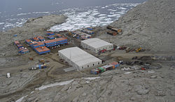
 Mario-Zucchelli-Station an der Terra Nova Bay | ||
Terra Nova Bay (englisch für Terra-Nova-Bucht) ist eine rund 64 km lange Bucht des Rossmeers an der Scott-Küste des ostantarktischen Viktorialands.
Die oft eisfreie Bucht befindet sich zwischen dem Kap Washington und der Drygalski-Eiszunge. Seit 1985 befindet sich an der Bucht die Mario-Zucchelli-Station (ehemals Terra-Nova-Bucht-Station), eine italienische Antarktis-Forschungsstation. Eine weitere Station an der Bucht ist die seit 1983 bestehende deutsche Gondwana-Station. In der Bucht liegt die Insel Inexpressible Island, an deren Südspitze China die Ganzjahres-Forschungsstation Qinling am 7. Februar 2024 offiziell in Betrieb nahm.
Ihren Namen erhielt die Bucht durch Robert Falcon Scott, dem Leiter der von 1901 bis 1904 durchgeführten Discovery-Expedition, der sie nach der Terra Nova benannte, einem der beiden Rettungsschiffe der Expedition.
Weblinks
- Terra Nova Bay. In: Geographic Names Information System. United States Geological Survey, United States Department of the Interior, archiviert vom (englisch).
- Terra Nova Bay auf geographic.org (englisch)
Auf dieser Seite verwendete Medien
Autor/Urheber: Alexrk2, Lizenz: CC BY-SA 3.0
Physische Positionskarte Antarktis, Mittabstandstreue Azimutalprojektion
Autor/Urheber: Andrew Mandemaker, Lizenz: CC BY 2.5
Stazione Mario Zucchelli at Terra Nova Bay, Antarctica, from the air. Italian research base. Looking north, shortly after sea ice break-out.
1:250,000-scale topographic reconnaissance map of the Mount Melbourne area from 162°-166°30'E to 74°-75°S in Antarctica. Mapped, edited and published by the U.S. Geological Survey in cooperation with the National Science Foundation.


