Teraina
| Teraina | ||
|---|---|---|
 | ||
| Gewässer | Pazifischer Ozean | |
| Inselgruppe | Line Islands | |
| Geographische Lage | 4° 41′ 0″ N, 160° 22′ 40″ W | |
| Länge | 6,8 km | |
| Breite | 2,5 km | |
| Fläche | 14,2 km² | |
| Höchste Erhebung | 5 m | |
| Einwohner | 1893 (2020[1]) 133 Einw./km² | |
| Hauptort | Matanibike | |
 | ||

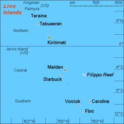
Teraina oder Washington Island, in neuerer Schreibung auch Teeraina, ist ein polynesisches, zum Staat Kiribati gehörendes Atoll. Es ist Teil der im zentralen Pazifischen Ozean gelegenen Inselkette der Line Islands. In der Vergangenheit wurde Teraina neben Washington Island auch New York oder Prospect genannt.
Geographie

Das Atoll liegt etwa 520 km nördlich des Äquators, rund 140 km nordwestlich von Tabuaeran (Fanning Island) und 223 km südöstlich von Palmyra. Es handelt sich um ein sogenanntes gehobenes Atoll, bei welchem die Lagune zum Binnensee, hier speziell zu einem Süßwassersee, geworden ist, dem Washington Lake. Die 279 Hektar Seefläche gelten damit als Teil der Inselfläche. Teraina ist etwa 7 km lang und bis zu 3 km breit und weist dabei eine Fläche von 14,2 km² auf. Die sandige Insel ist fast vollständig von einem Korallenriff umgeben, das Anlanden mit Booten ist nur an der Westspitze in der Nähe des Hauptortes möglich und gilt als schwierig.
Auf der Insel leben annähernd 1900 Einwohner (Stand 2020), deren Haupteinkommensquelle die Produktion von Kopra ist.[2] Sie verteilen sich auf neun Siedlungen.[3]
Die einzelnen Siedlungen gegen den Uhrzeigersinn von Nordosten aus: ![]() Karte mit allen Koordinaten: OSM | WikiMap
Karte mit allen Koordinaten: OSM | WikiMap
| Dorf | Bevölkerung (Volkszählung) | Koordinaten | |||
|---|---|---|---|---|---|
| 2005[4] | 2010[5] | 2015[6] | 2020[7] | ||
| Abaiang | 91 | 146 | 145 | 215 | 4,6886° N, 160,3637° W |
| Kauamwemwe | 106 | 198 | 244 | 173 | 4,69° N, 160,3701° W |
| Uteute | 72 | 141 | 104 | 55 | 4,6938° N, 160,3783° W |
| Kaaitara (Tekaitara) | 34 | - | 51 | 95 | 4,6968° N, 160,3859° W |
| Tangkore | 203 | 410 | 413 | 582 | 4,6976° N, 160,4031° W |
| Matanibike (Hauptort) | 191 | 91 | - | 296 | 4,6907° N, 160,4091° W |
| Arabata | 190 | 353 | 342 | 149 | 4,6855° N, 160,4056° W |
| Mwakeitari | 92 | 177 | 213 | 221 | 4,6734° N, 160,3841° W |
| Onauea | 176 | 174 | 200 | 107 | 4,6704° N, 160,3769° W |
| Teraina gesamt | 1155 | 1690 | 1712 | 1893 | 4,6833° N, 160,3778° W |
Geschichte
Das Atoll wurde am 12. Juni 1798 vom US-amerikanischen Forscher Edmund Fanning (1769–1841) gesichtet, der sie nach dem ersten Präsidenten der USA, George Washington, benannte. Unter Berufung auf den 1856 verabschiedeten Guano Islands Act wurde Washington Island zwar von den Vereinigten Staaten beansprucht, jedoch nicht in Besitz genommen. Im Jahre 1889 wurde die tropische Insel vom Britischen Empire annektiert und 2016 der Kolonie Gilbert- und Elliceinseln zugeordnet.[8] Seit 1979 gehört sie zum Inselstaat Kiribati und wird offiziell Teraina genannt.
Literatur
- L. Wester, J.O. Juvik und P. Holthus: Vegetation History of Washington Island (Teraina), Northern Line Islands. Atoll Research Bulletin, No. 358, Mai 1992 (PDF; 2,1 MB)
- Teeraina (= Republic of Kiribati Island Report Series. Nr. 22). Republic of Kiribati – Office of Te Beretitenti, 2012 (englisch, web.archive.org [PDF; 1,1 MB]).
Weblinks
- Links zu amtlichen Berichten mit Statistiken und Karten ( vom 3. Oktober 2013 im Internet Archive)
- Teraina. In: teraina.com. (englisch).
- Teraina auf oceandots.com ( vom 23. Dezember 2010 im Internet Archive) (englisch)
- Jane Resture: Washington Island – A Paradise For Fishing. In: janeresture.com. 30. September 2022 (englisch).
Einzelnachweise
- ↑ Aritita Tekaieti (Hrsg.): 2020 Population and Housing General Report and Results. Republic of Kiribati – National Statistics Office, Ministry of Finance, Juli 2021, Table G-2: Total population of Kiribati by division, island and sex: 2020 PHC Kiribati, S. 18 (englisch, Downloadlink [PDF; 48,2 MB; abgerufen am 2. März 2023]).
- ↑ Teeraina (= Republic of Kiribati Island Report Series. Nr. 22). Republic of Kiribati – Office of Te Beretitenti, 2012, Island Economy: Copra, S. 9 (englisch, web.archive.org [PDF; 1,1 MB; abgerufen am 28. Juni 2024]).
- ↑ Teeraina Island 2008 Socio-Economic Profile. Band 1. Republic of Kiribati – Ministry of Internal and Social Affairs, 2008, 3.1.3. Population Density, S. 22 (englisch, web.archive.org [PDF; 1,9 MB; abgerufen am 28. Juni 2024]).
- ↑ Aritita Tekaieti (Hrsg.): 2005 Census of Population – Volume 1: Basic information and tables (Revised version). Republic of Kiribati – National Statistics Office, Ministry of Finance, 17. Januar 2007, Table 3: Population by island, sex, village and broad age group – 2005, S. 20–31, hier: S. 30 (englisch, Downloadlink [PDF; 1,1 MB; abgerufen am 1. März 2023]).
- ↑ Aritita Tekaieti, Tekena Tiroa (Hrsg.): Report on the Kiribati 2010 Census of Population and Housing – Vol 1: Basic Information and Tables. Republic of Kiribati – National Statistics Office, Ministry of Finance and Economic Planning, August 2012, Table 3: Population by village, sex and age group – 2010, S. 34–50, hier: S. 49 (englisch, mfed.gov.ki [PDF; 6,7 MB; abgerufen am 2. März 2023]).
- ↑ Orebwa Morate (Hrsg.): 2015 Population and Housing Census – Volume 1: Management Report and Basic Tables. Republic of Kiribati – National Statistics Office, Ministry of Finance, 1. September 2016, Table 3: Population by Village, Sex, And Age Group: 2015, S. 35–51, hier: S. 49 f. (englisch, mfed.gov.ki [PDF; 3,0 MB; abgerufen am 2. März 2023]).
- ↑ Kiribati – Population and Housing Census 2020. Value 2001–2009. In: microdata.pacificdata.org. Pazifische Gemeinschaft, 25. Juni 2024, abgerufen am 7. September 2024 (englisch).
- ↑ Teeraina Island 2008 Socio-Economic Profile. Band 1. Republic of Kiribati – Ministry of Internal and Social Affairs, 2008, 2.1.6. History and Culture, S. 19–20 (englisch, web.archive.org [PDF; 1,9 MB; abgerufen am 28. Juni 2024]).
Auf dieser Seite verwendete Medien
NASA-Astronautenbild der Insel Teraina, Kiribati, im Pazifischen Ozean
Autor/Urheber: Government of USA, Government of Kiribati, Lizenz: CC BY-SA 3.0
Astronaut photo of Teeraina, Kiribati with villages and main landmarks
Ein Maneaba, typisches Versammlungshaus einer Sippe auf Teraina (Washington Island), Line Islands, Kiribati
Autor/Urheber: Uwe Dedering, Lizenz: CC BY-SA 3.0
Location map of Kiribati
Equirectangular projection. Geographic limits of the map:
- N: 6° N
- S: 13° S
- W: 169° E
- E: 149° W
Made with Natural Earth. Free vector and raster map data @ naturalearthdata.com.
Sea-Borders from the political map made by NNWMap (rough) of the Line Islands, Kiribati, own work composed from various mapreferences
I-Kiribati:Teraina, Kiribati. English:Washington Island, Kiribati.


