Teluk Sapanggar
| Teluk Sapanggar Sepangar Bay | ||
|---|---|---|
 Teluk Sapanggar von Kg. Gentisan | ||
| Gewässer | Südchinesisches Meer | |
| Landmasse | Borneo | |
| Geographische Lage | 6° 5′ 0″ N, 116° 7′ 0″ O | |
| ||
| Breite | ca. 3,5 km | |
| Tiefe | ca. 6 km | |
| Fläche | 20 km² | |
| Küstenlänge | 12 km | |
| Inseln | Pulau Sapanggar, P. Udar Kecil, P. Udar Besar, P. Peduk (der Bucht vorgelagert) | |
| Zuflüsse | Sungai Menggatal | |
Die Sepangar Bay oder Sapangar Bay (malaiisch Teluk Sapanggar) ist eine Bucht an der Westküste der Insel Borneo. Sie gehört zum malaysischen Bundesstaat Sabah und öffnet sich zum Südchinesischen Meer. Verwaltungstechnisch gehört sie zum Distrikt Kota Kinabalu in der West Coast Division.[1]
Geographie
Die Bucht umfasst eine Fläche von ca. 20 km². Die Bucht erstreckt sich in einem weiten Bogen von Pulau Sapanggar bis Kap Tarak Tarak (mal. Tanjung Tarak Tarak). Der Bucht vorgelagert sind die Inseln Pulau Sapanggar, Pulau Udar Kecil, Pulau Udar Besar und Pulau Peduk. Die Küstenlinie ist überwiegend unbewaldet, mit industrieller und maritimer Nutzung.[2]
Nutzung der Bucht
Die Bucht wird in erster Linie als Güterhafen, als Marinehafen und als industrieller Standort genutzt. Daneben gibt es einige handwerkliche Betriebe, die mit der Instandhaltung und Konstruktion von Schiffen beschäftigt sind.

Container Terminal
Nach Inbetriebnahme des Containerterminals Sepangar Container Port Terminal wurde der gesamte Containerumschlag aus dem Hafen von Kota Kinabalu hierher verlagert.[3]
Marinestützpunkt
Nach dem Ausbau beherbergt der Marinestützpunktes seit 2010 zwei in Spanien gebaute U-Boote der Scorpène-Klasse, die KD Tunku Abdul Rahman und KD Tun Razak.[4]
Weblinks
Weitere Bilder
 Photo by CEphoto, Uwe Aranas or alternatively © CEphoto, Uwe Aranas, CC BY-SA 3.0Sepangar Oil Terminal
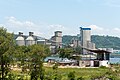 Cement Industries Snd. Bhd.
 Photo by CEphoto, Uwe Aranas or alternatively © CEphoto, Uwe Aranas, CC BY-SA 3.0Verwaltungsgebäude Sabah Ports
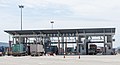 Photo by CEphoto, Uwe Aranas or alternatively © CEphoto, Uwe Aranas, CC BY-SA 3.0Zufahrt zum Containerterminal
Einzelnachweise
- ↑ Administrative District Boundary and Local Authority Area. In:Census 2010 für Sabah ( des vom 27. Februar 2012 im Internet Archive) Info: Der Archivlink wurde automatisch eingesetzt und noch nicht geprüft. Bitte prüfe Original- und Archivlink gemäß Anleitung und entferne dann diesen Hinweis. (PDF; 1,9 MB) Amt für Statistik, Malaysia, S. 153.
- ↑ Sailing Directions (Enroute) – Borneo, Jawa, Sulawesi and NUsa Tenggara ( des vom 4. März 2016 im Internet Archive) Info: Der Archivlink wurde automatisch eingesetzt und noch nicht geprüft. Bitte prüfe Original- und Archivlink gemäß Anleitung und entferne dann diesen Hinweis. (PDF; 5,8 MB) United States Navy Publication 163, S. 345, 2002; abgerufen am 29. August 2012
- ↑ Sapangar Container Port Terminal ready. In: Daily Express News, 8. August 2006
- ↑ Second Scorpene sub here in June. In: The Star, 12. Januar 2010; abgerufen am 9. Juli 2012
Agal Bay | Brunei Bay | Cowie Bay | Darvel Bay | Kimanis Bay | Labuk Bay | Marchesa Bay | Padas Bay | Paitan Bay | Sandakan Bay | Sepangar Bay | Schomburgk Bay | Tambak Bay | Marudu Bay
Auf dieser Seite verwendete Medien
Autor/Urheber: CEphoto, Uwe Aranas, Lizenz: CC BY-SA 3.0
Sabah: Sepangar Bay from Kg. Gentisan

Autor/Urheber: Uwe Dedering, Lizenz: CC BY-SA 3.0
Location map of Malaysia.
Equirectangular projection. Strechted by 100.0%. Geographic limits of the map:
* N: 8.0° N
* S: 0.0° N
* W: 99.0° E
* E: 120.0° E
Made with Natural Earth. Free vector and raster map data @ naturalearthdata.com.

Autor/Urheber: CEphoto, Uwe Aranas, Lizenz: CC BY-SA 3.0
Sabah: Sepangar Bay , Cement Industries

Photo by CEphoto, Uwe Aranas or alternatively © CEphoto, Uwe Aranas, CC BY-SA 3.0
Sabah: Sepangar Bay, Sabah Ports

Photo by CEphoto, Uwe Aranas or alternatively © CEphoto, Uwe Aranas, CC BY-SA 3.0
Sabah: Sepangar Bay, Sabah Ports Building

Flag of the Malaysian state Sabah. Based on a GIF from a government website, colors from a photo. Drawn by Mysid. The flag was adopted September 16, 1988.
- The mountain on the left is Mount Kinabalu.
Per the Constitution of the State of Sabah:
"The State Flag is in a rectangular shape and is in the proportion of 1:2. The canton which extends at the head half way to the fly and 2/3 at the hoist to the foot is in Icicle Blue (C1T9) as the background to a graphic silhouette of Mount Kinabalu which is in Royal Blue (B10) positioned at ¼ of the height of the canton from end to end. The fly of the flag is divided equally into three bands of colours the foot division of which extends right to the hoist. The top band is in Zircon Blue (C5T5) the second band is in white and the third band is in Chili Red (S6R4)."Autor/Urheber: CEphoto, Uwe Aranas, Lizenz: CC BY-SA 3.0
Sabah: Sepangar Bay, Royal Malaysian Navy Harbour

Photo by CEphoto, Uwe Aranas or alternatively © CEphoto, Uwe Aranas, CC BY-SA 3.0
Kota Kinabalu, Sabah: Sapangar Bay Oil Terminal