Telipok
| Telipok | ||
|---|---|---|
| Koordinaten | 6° 5′ N, 116° 12′ O | |
| Basisdaten | ||
| Staat | Malaysia | |
| Bundesstaat | Sabah | |
| ISO 3166-2 | MY-12 | |
| Einwohner | 432 (2010[1]) | |
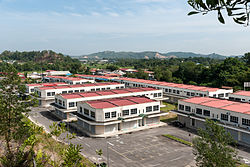
Photo by CEphoto, Uwe Aranas or alternatively © CEphoto, Uwe Aranas, CC BY-SA 3.0 Neubaugebiet Ria Park; im Hintergrund das alte Zentrum von Telipok | ||
Telipok (auch Telipuk) ist eine Kommune im Bundesstaat Sabah in Malaysia. Telipok gehört zu den Außenbezirken der Hauptstadt Kota Kinabalu und ist als Unterdistrikt der Verwaltung des Dewan Bandaraya Kota Kinabalu (Stadtrat Kota Kinabalu) zugeordnet.
Demographie
Der Zahl der Einwohner des Vororts lag laut Census 2010 bei 432 Einwohnern,[1] spiegelt jedoch nicht die wirklichen Verhältnisse wider. Eine beträchtlicher Anzahl nichtregistrierter Einwohner entstammt illegaler Zuwanderung aus den Philippinen und aus Indonesien. Zur Bekämpfung illegaler Ansiedlungen und um die Bildung von Elendsvierteln einzudämmen, hat die Regierung in den vergangenen Jahren in Telipok mehrere tausend Billigwohnungen geschaffen.[2]
Geschichte
Der Platz war ursprünglich von Kadazan und Bajau besiedelt. Ab 1913 siedelte die North Borneo Chartered Company hier auf Betreiben der Basler Missionsgesellschaft eine kleinere Gruppe lutheranische Hakka-Chinesen aus der Provinz Kanton an. Die insgesamt etwa 600 Menschen wurden auf Kudat, Menggatal, Telipok und Inanam verteilt und mit einem Darlehen sowie Werkzeugen versorgt.[3] Diese Anfänge waren die Grundlage für die heute noch starke chinesische Gemeinschaft dieser vier Ortschaften.
Zu den Vorkriegs-Persönlichkeiten der chinesischen Gemeinschaft Telipoks gehörte Li Thet Phui, ein Lieutenant der North Borneo Volunteer Force und stellvertretender Vorsitzender des China Relief Fund. Er gehörte zu den fünf Männern, die am 21. Januar 1944 in Kg. Petagas von japanischen Offizieren enthauptet wurden. Er wurde zusammen mit den anderen Opfern des Massakers auf dem Gelände des heutigen Petagas War Memorial begraben.[4]
Infrastruktur
Die Stadt ist über die Jalan Tuaran und Jalan Lintas mit dem 15 Kilometer entfernten Zentrum von Kota Kinabalu verbunden. Die nächste Vororte sind Menggatal, Sepanggar und Tuaran.
Literatur
- K. G. Tregonning: A History Of Modern Sabah (North Borneo 1881–1963), 2. Ausgabe. University of Malaya Press, Kuala Lumpur 1965; Reprint 1967.
- Owen Rutter: British North Borneo – An Account of its History, Ressources and Native Tribes. Constable & Company, London 1922; archive.org.
- W. H. Treacher: British Borneo – Sketches of Brunai, Sarawak, Labuan and North Borneo. Government print department, Singapore 1891; archive.org.
Weblinks
Einzelnachweise
- ↑ a b Census 2010 für Sabah ( des vom 27. Februar 2012 im Internet Archive) Info: Der Archivlink wurde automatisch eingesetzt und noch nicht geprüft. Bitte prüfe Original- und Archivlink gemäß Anleitung und entferne dann diesen Hinweis. (PDF; 1,9 MB) Amt für Statistik, Malaysia
- ↑ 1000 Low cost houses built in Telipok. Borneo Today, 19. November 2007; abgerufen am 22. April 2012.
- ↑ K. G. Tregonning: A History Of Modern Sabah (North Borneo 1881–1963), 2. Ausgabe. University of Malaya Press, Kuala Lumpur 1965; Reprint 1967, S. 149
- ↑ Danny Wong Tze Ken: Historical Sabah: The War. Opus Publications Kota Kinabalu, 2010, ISBN 978-983-3987-37-5, S. 160.
Auf dieser Seite verwendete Medien
Autor/Urheber: Uwe Dedering, Lizenz: CC BY-SA 3.0
Location map of Malaysia.
Equirectangular projection. Strechted by 100.0%. Geographic limits of the map:
* N: 8.0° N
* S: 0.0° N
* W: 99.0° E
* E: 120.0° E
Made with Natural Earth. Free vector and raster map data @ naturalearthdata.com.
Photo by CEphoto, Uwe Aranas or alternatively © CEphoto, Uwe Aranas, CC BY-SA 3.0
Telipok, Sabah: Old Shophouse)
Flag of the Malaysian state Sabah. Based on a GIF from a government website, colors from a photo. Drawn by Mysid. The flag was adopted September 16, 1988.
- The mountain on the left is Mount Kinabalu.
Per the Constitution of the State of Sabah:
"The State Flag is in a rectangular shape and is in the proportion of 1:2. The canton which extends at the head half way to the fly and 2/3 at the hoist to the foot is in Icicle Blue (C1T9) as the background to a graphic silhouette of Mount Kinabalu which is in Royal Blue (B10) positioned at ¼ of the height of the canton from end to end. The fly of the flag is divided equally into three bands of colours the foot division of which extends right to the hoist. The top band is in Zircon Blue (C5T5) the second band is in white and the third band is in Chili Red (S6R4)."Photo by CEphoto, Uwe Aranas or alternatively © CEphoto, Uwe Aranas, CC BY-SA 3.0
Telipok, Sabah: Ria Park, a new Quarter behind the old town center)


