Taupō Volcanic Zone


Die Taupō Volcanic Zone ist ein aktives Vulkangebiet auf der Nordinsel Neuseelands. Sie ist nach dem Vulkan Taupō benannt, der mit seiner gefluteten Caldera, dem Lake Taupō, der größte Vulkan dieser Zone ist.
Aktivität
In der Zone befinden sich zahlreiche Vulkanschlote und Geothermalfelder, von denen der Mount Ruapehu, Mount Ngauruhoe und der Inselvulkan Whakaari / White Island am häufigsten ausbrechen. Die bedeutendste Eruption seit Ankunft der Europäer in Neuseeland war die des Mount Tarawera im Jahre 1886, der mehr als 100 Menschen zum Opfer fielen. Nach Ankunft der ersten Māori fand um 1300 eine viel größere Eruption des gleichen Vulkans statt.[1]
Die letzte bedeutende Eruption des Taupō, die Hatepe, ereignete sich im Jahre 181. Man nimmt an, dass sie zu einem Pyroklastischen Strom führte, der etwa 2000 km² Land mit Vulkanasche bedeckte. Die ausgestoßene Materialmenge wurde auf 120 km³ geschätzt, davon über 30 km³ in nur wenigen Minuten. Das Datum des Ausbruchs ist bekannt, da die Asche zu einem rot gefärbten Himmel in Rom und China führte. Letzteres wurde im Hou Hanshu dokumentiert.
Vor etwa 26.000 Jahren kam es mit der Oruanui Eruption zu einem noch weit größeren Ausbruch mit geschätzten 1170 km³ Volumen. Sie war die jüngste Eruption weltweit, die VEI-8, die höchste Stufe des Vulkanexplosivitätsindex erreichte.
Die Rotorua ist bereits länger nicht aktiv, die bedeutendste Eruption fand vor etwa 240.000 Jahren statt, in den letzten 25.000 Jahren wurden jedoch Lavadome gebildet.[2]
Ausdehnung und geologischer Kontext
Die Taupō Volcanic Zone ist etwa 350 km lang und 50 km breit. Mount Ruapehu markiert sein südwestliches Ende, der unterseeische Vulkan Whakatane, rund 85 km vor Whakaari / White Island, wird als nordöstliche Grenze angesehen.[3]
Sie bildet den südlichen Teil des aktiven Lau-Havre-Taupo-Backarc-Beckens, das hinter der Kermadec-Tonga-Subduktionszone liegt.[4] Die vulkanische Aktivität setzt sich über mehrere Unterseevulkane von der Taupō Volcanic Zone nach Nord-Nordosten fort, darunter Clark, Tangaroa, die Silents und die Rumbles. Dann wendet sich die aktive Zone nach Osten der parallel verlaufenden Vulkankette der Kermadec Islands und der Insel Tonga zu. Obwohl sich das Backarc Basin nach Südwesten fortsetzt (das South Wanganui Basin bildete dabei das ursprüngliche Basin), ist aus dieser Region noch keine vulkanische Aktivität bekannt.[5] Die Taupō Volcanic Zone kann daher als südwestliches Ende des Pazifischen Feuerrings angesehen werden, der die Subduktionszonen um den Pazifik markiert.
Südlich von Kaikoura wandelt sich die Plattengrenze in eine Transformstörung, an der die sich übereinander schiebenden tektonischen Platten die Südalpen auf der Südinsel anheben. Südwestlich von Fiordland an der Südwestecke der Südinsel beginnt erneut eine Subduktionszone, hier jedoch in die entgegengesetzte Richtung. Solander Island ist ein erloschener Vulkan, der neben anderen unterseeischen Vulkanen mit dieser Subduktionszone in Verbindung gebracht wird.
Studien zeigten, dass die Erdkruste unter der Taupō Volcanic Zone nur 16 km stark ist. Eine 50 km breite und 160 km lange Schicht Magma liegt nur zehn Kilometer unter der Oberfläche.[6][7] Die geologischen Funde zeigen, dass einige der Vulkane selten ausbrechen, dann aber große, explosive und zerstörerische Ausbrüche zeigen.
Vulkane, Seen und geothermale Felder

Zur Taupō Volcanic Zone gehören die Vulkanzentren Rotorua, Okataina, Maroa, Taupō, Tongariro und Mangakino.[8][9]
- Whakatane-Graben, Bay of Plenty
- Whakatane-Vulkan (Unterseevulkan)
- Mayor Island / Tūhua
- Moutohora Island (Whale Island)
- Whakaari / White Island
- Te Paepae o Aotea
- Mount Edgecumbe
- Geothermales Feld
- Kawerau Power Station
- Rotorua Volcanic Center
- Caldera des Rotorua
- Ngongotaha (Vulkan)
- Seen
- Lake Rotorua
- Mokoia Island
- Lake Rotorua
- Geothermale Felder
- Tikitere/Hell's Gate
- Whakarewarewa
- Pohutu Geyser
- Takeke
- Okataina Volcanic Center
- Caldera des Haroharo
- Vulkankomplex des Haroharo
- Mount Tarawera und der Vulkankomplex des Tarawera
- Rotoma Caldera[10]
- Seen
- Lake Ōkataina
- Lake Tarawera
- Lake Rotokākahi / Green Lake
- Tikitapu/Blue Lake
- Lake Ōkareka
- Lake Rotomahana
- Lake Rotoiti
- Lake Rotomā
- Lake Rotoehu
- Geothermale Felder
- Waimangu Volcanic Rift Valley
- Rotoma
- Caldera des Haroharo
- Maroa Volcanic Center: Die Caldera des Maroa liegt im Nordosten der Caldera des Whakamaru, die Caldera des Whakamaru überlappt zum Teil die Caldera des Taupō im Süden. Der Flusslauf des Waikato River folgt der Nord Rand der Caldera des Maroa. Die Stadt Whakamaru und der Stausee Whakamaru am Waikato River, haben auch den gleichen Namen.
- Caldera des Maroa
- Caldera des Reporoa
- Caldera des Whakamaru
- Geothermale Felder
- Wai-O-Tapu
- Wairakei
- Craters of the Moon (Karapiti)
- Orakei Korako
- Ngatamariki
- Rotokaua
- Ohaaki Power Station
- Taupō Volcanic Center
- Taupō
- Mount Tauhara
- Ben Lomond
- Seen
- Lake Taupō
- Horomatangi Riffe
- Motutaiko Island
- Lake Taupō
- Geothermale Felder
- Tauhara-Taupō
- Taupō
- Tongariro Volcanic Center: Lake Taupō, Kakaramea, Pihanga, Tongariro und Ruapehu sind etwa in einer Linie auf der Hauptstörung angeordnet.
- Kakaramea
- Pihanga
- Mount Tongariro und Vulkankomplex des Tongariro
- Mount Ngauruhoe
- Tama Lakes
- Mount Ruapehu
- Hauhungatahi
- Seen
- Lake Rotoaira
- Lake Rotopounamu
- Geothermale Felder
- Ketetahi Springs
- Mangakino Volcanic Center
Es besteht auch eine weitere Klassifikation der Vulkanzone:[11][12]
- Nordteil: Whakatane-Graben – Bay of Plenty
- Zentralteil:
- westlich der Hauptstörung:
- Calderakomplex Mangakino; möglicherweise Übergang zur Coromandel Volcanic Zone (CVZ) (0,91–1,62 Millionen Jahre alt)
- Caldera des Kapenga; zwischen der Caldera des Maroa und der Caldera des Rotorua, völlig von rezenter Tephra bedeckt, etwa 700.000 Jahre alt
- Okareka Einbuchtung, innerhalb des Nordendes der Caldera des Kapenga, zwischen dem Vulkankomplex des Tarawera und dem Lake Rotorua[10]
- „Rotorua single event caldera“ aus Mamaku-Ignimbrit (entstand bei einem Einzelausbruch vor etwa 240.000 Jahren)
- Hauptstörung:
- Calderakomplex Okataina
- Calderakomplex Haroharo
- Vulkankomplex des Tarawera
- Okareka Bay
- Calderakomplex Haroharo
- Calderakomplex Whakamaru
- Caldera des Maroa
- „Ohakuri single event caldera“; Ohakuri-Ignimbrit; liegt westlich des Ohakuri Dam, der Waikato RiverWaikato River folgt etwa dem südlichen Rand der Caldera (entstand bei einem Einzelausbruch vor etwa 240.000 Jahre alt).[13]
- Calderakomplex des Taupō
- Calderakomplex Okataina
- östlich der Hauptstörung:
- „Reporoa single event caldera“; Kaingaroa-Ignimbrit (entstand bei einem Einzelausbruch vor etwa 240.000 Jahre alt)
- westlich der Hauptstörung:
- Südteil: Tongariro-Vulkanzentrum
Galerie
 Südwestseite des Mount Tarawera, Mount Edgecumbe im Hintergrund
 Rotorua-Caldera
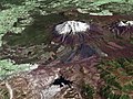 Satellitenbild des Mount Ruapehu
 Panorama über den Lake Taupō
Siehe auch
Weblinks
- New Zealand's volcanoes. GNS Science, abgerufen am 2. Februar 2023 (englisch).
- Bruce F. Houghton: Field Guide. (PDF; 5,3 MB) Taupo Volcanic Zone. In: hawaii.edu. 2007, abgerufen am 2. Februar 2023 (englisch).
Einzelnachweise
- ↑ David J. Lowe: Guidebook for ‘Land and Lakes’ field trip, New Zealand Society of Soil Science Biennial Conference, Rotorua, 27.-30. November 2006. New Zealand Society of Soil Science, Polynesian settlement and impacts of volcanism on early Maori society, S. 50–55 (englisch, Online [PDF; 4,8 MB; abgerufen am 18. März 2009]).
- ↑ Rotorua im Global Volcanism Program der Smithsonian Institution (englisch)
- ↑ J. A. Gamble, I. C. Wright, J. A. Baker: Seafloor geology and petrology in the oceanic to continental transition zone of the Kermadec‐Havre‐Taupo Volcanic Zone arc system, New Zealand. In: The Royal Society of New Zealand (Hrsg.): New Zealand Journal of Geology and Geophysics. Vol. 36, No. 4. Wellington 1993, S. 417–435, doi:10.1080/00288306.1993.9514588 (englisch).
- ↑ L. M. Parson, I. C. Wright: The Lau-Havre-Taupo back-arc basin: A southward-propagating, multi-stage evolution from rifting to spreading. In: Tectonophysics. Vol. 263, 1996, S. 1–22, doi:10.1016/S0040-1951(96)00029-7 (englisch).
- ↑ P. Villamor, K. R. Berryman: Evolution of the southern termination of the Taupo Rift, New Zealand. In: The Royal Society of New Zealand (Hrsg.): New Zealand Journal of Geology and Geophysics. Volume 49, Issue 1. Wellington 2006, S. 23–37, doi:10.1080/00288306.2006.9515145 (englisch).
- ↑ Paul Easton: Central North Island sitting on magma film. The Dominion Post, 15. September 2007, archiviert vom am 7. Januar 2009; abgerufen am 16. März 2008 (englisch).
- ↑ W. Heise, H. M. Bibby, T. G. Caldwell: Imaging magmatic Processes in the Taupo Volcanic Zone (New Zealand) with Magnetotellurics. In: Geophysical Research Abstracts. Band 9, 2007 (englisch, Online [PDF]).
- ↑ J. W. Cole: Structural control and origin of volcanism in the Taupo volcanic zone, New Zealand. In: Bulletin of Volcanology. Band 52, 1990, S. 445–459, doi:10.1007/BF00268925 (englisch).
- ↑ New Zealand. Archiviert vom am 12. Juni 2011; abgerufen am 3. Februar 2011 (englisch).
- ↑ a b K. A. Hodgson, I. A. Nairn: The Sedimentation and Drainage History of Haroharo Caldera and The Tarawera River System, Taupo Volcanic Zone, New Zealand. In: Bay of Plenty Regional Council (Hrsg.): Environment Bay of Plenty Operations Publication. Band 2004/03. Whakatane August 2004 (englisch, Online [PDF; 488 kB; abgerufen am 24. Januar 2016]).
- ↑ J. W. Cole, K. D. Spinks: Caldera volcanism and rift structure in the Taupo Volcanic Zone, New Zealand. In: Special Publications. Band 327. Geological Society, 2009, S. 9–29, doi:10.1144/SP327.2 (englisch, Online).
- ↑ J. Hiess, J. W. Cole, K. D. Spinks: High-Alumina Basalts of the Taupo Volcanic Zone, New Zealand: Influence of the Crust and Crustal Structure. Part of a BSc Project by Hiess, J. (University of Canterbury). 2007, S. 36 (englisch, Online [PDF]).
- ↑ D. M. Gravley, C. J. N. Wilson, M. D. Rosenberg, G. S. Leonard: The nature and age of Ohakuri Formation and Ohakuri Group rocks in surface exposures and geothermal drillhole sequences in the central Taupo Volcanic Zone, New Zealand. doi:10.1080/00288306.2006.9515169 (englisch).
Auf dieser Seite verwendete Medien

Panorama of Lake Taupo, North Island, New Zealand
en:Mount Ngauruhoe is the tallest peak of the Tongariro complex in the North Island of New Zealand.
Source: Photo by Don Swanson, 1984 (U.S. Geological Survey). (see for wrongly titled original location)Bay of Plenty, North Island, New Zealand, from the Bay of Plenty coast to Mounts Tongariro, Ngauruhoe, and Ruapehu (at bottom of picture). Also shows Lake Taupo and the Rotorua Lakes. This scene was acquired by the Moderate Resolution Imaging Spectroradiometer (MODIS), flying aboard NASA’s Terra satellite, on October 23, 2002

Composite image of Mount Ruapehu, with Hauhungatahi visible beyond. North Island, New Zealand. Image is composed of satellite imagery from Landsat and topography data from the Shuttle Radar Topography Mission aboard the Space Shuttle Endeavour.

Autor/Urheber: Carl Lindberg, Lizenz: CC BY 2.5
Aerial view of the south side of Mount Tarawera, Bay of Plenty region, North Island, New Zealand. Taken during a seaplane ride out of nearby Rotorua.
(c) James Shook, CC BY 2.5
Aerial photograph of White Island (Whakaari) in the Bay of Plenty, The North Island, New Zealand

en:NASA World Wind false-colour landsat-7 composite satellite photo of en:Lake Rotorua in en:New Zealand. en:Category:Taupo Volcanic Zone

Autor/Urheber: Avenue, Lizenz: CC BY-SA 3.0
View from the middle of the fissure running across the top of Mount Tarawera. This fissure was created when the mountain exploded in 1886.