Tabontabon
| Municipality of Tabontabon | ||
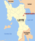
| Lage von Tabontabon in der Provinz Leyte | ||
|---|---|---|
 | ||
| Basisdaten | ||
| Region: | Eastern Visayas | |
| Provinz: | Leyte | |
| Barangays: | 16 | |
| Distrikt: | 2. Distrikt von Leyte | |
| PSGC: | 083746000 | |
| Einkommensklasse: | 5. Einkommensklasse | |
| Haushalte: | 1692 Zensus 1. Mai 2000 | |
| Einwohnerzahl: | 11.204 Zensus 1. August 2015 | |
| Koordinaten: | 11° 2′ N, 124° 58′ O | |
| Geographische Lage auf den Philippinen | ||
| ||
Tabontabon ist eine philippinische Stadtgemeinde in der Provinz Leyte. Sie hat 11.204 Einwohner (Zensus 1. August 2015).
Baranggays
Tabontabon ist politisch in 16 Baranggays unterteilt.
|
|
Auf dieser Seite verwendete Medien
(c) Karte: NordNordWest, Lizenz: Creative Commons by-sa-3.0 de
Positionskarte der Philippinen
Autor/Urheber: Mike Gonzalez (TheCoffee), Lizenz: CC-BY-SA-3.0
Map of Leyte showing the location of Tabontabon


