Tōkyō-Gaikan-Autobahn
| Tōkyō-Gaikan-Autobahn in Japan | |||||||||||||||||||||||||||||||||||||||||||||||||||||||||||||||||||
 | |||||||||||||||||||||||||||||||||||||||||||||||||||||||||||||||||||
| Karte | |||||||||||||||||||||||||||||||||||||||||||||||||||||||||||||||||||
 | |||||||||||||||||||||||||||||||||||||||||||||||||||||||||||||||||||
| Basisdaten | |||||||||||||||||||||||||||||||||||||||||||||||||||||||||||||||||||
| Betreiber: | NEXCO Higashi-Nihon | ||||||||||||||||||||||||||||||||||||||||||||||||||||||||||||||||||
| Straßenbeginn: | Setagaya | ||||||||||||||||||||||||||||||||||||||||||||||||||||||||||||||||||
| Straßenende: | Ichikawa | ||||||||||||||||||||||||||||||||||||||||||||||||||||||||||||||||||
| Gesamtlänge: | 34 km | ||||||||||||||||||||||||||||||||||||||||||||||||||||||||||||||||||
| davon in Betrieb: | 37 km | ||||||||||||||||||||||||||||||||||||||||||||||||||||||||||||||||||
 | |||||||||||||||||||||||||||||||||||||||||||||||||||||||||||||||||||
Straßenverlauf
| |||||||||||||||||||||||||||||||||||||||||||||||||||||||||||||||||||
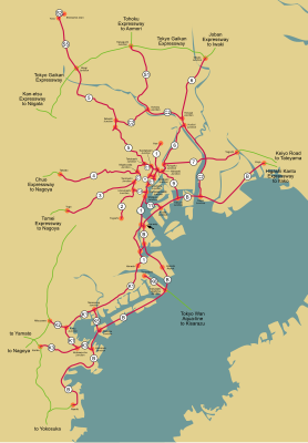
Die Tokyo-Gaikan-Autobahn (jap. 東京外環自動車道, Tōkyō Gaikan jidōshadō, dt. „Außenringautobahn Tokio“) ist eine Autobahn in Japan. Sie trägt die Nummer C3. Die Autobahn ist der dritte Ring der Hauptstadt Tokio und derzeit nur eine Nordumgehung, soll aber in Zukunft als ein Dreiviertel-Ring aus der Tōmei-Autobahn bei Setagaya und der Higashi-Kantō-Autobahn bei Ichikawa genutzt werden. Derzeit abgeschlossen sind 34 km der Strecke im Norden von Tokio.
Straßenbeschreibung
Die Autobahn beginnt derzeit am Knoten Oizumi, wo die Kan’etsu-Autobahn beginnt, die nach Niigata läuft. Die Autobahn verläuft anschließend in Richtung Nordosten, verfügt über 2 × 3 Fahrspuren und führt durch zahlreiche Orte. Im weiteren Verlauf wird der Fluss Arakawa gekreuzt und es folgt eine Kreuzung mit der Stadtautobahn Tokio Route 5 und der Route S5. Die Autobahn verfügt über 2 × 2 Fahrspuren und verläuft durch den Süden der Präfektur Saitama. Ein wichtiger Knoten folgt bei Kawaguchi, wo sie die Stadtautobahn Route S1 und die Tōhoku-Autobahn kreuzt. Anschließend führt die Straße durch die Vororte von Tokio bis zur Kreuzung Misato, wo sie die Stadtautobahn Route 6 und die Jōban-Autobahn kreuzt. Die Autobahn verläuft von dort aus bis Matsudo, wo die Autobahn an der Nationalstraße 298 endet.
Geschichte
Bereits im Jahr 1966 wurde beschlossen, die Autobahn zu bauen, jedoch dauerte es bis zum Jahr 1992, bis der erste Abschnitt zwischen dem Knotenpunkt Misato und der Ausfahrt Wako eröffnet wurde. Im Jahr 1993 öffnete die Kreuzung mit der Route 5 der Stadtautobahn. Im Jahr 1994 öffnete der Knoten von Wako zur Kan’etsu-Autobahn. Im Jahr 2005 eröffnete ein Abschnitt bei Misato.
Eröffnungsdaten der Autobahn
| von | nach | Länge | Datum |
|---|---|---|---|
| Wako | Misato | 27 km | 27.11.1992 |
| Oizumi | Wako | 3 km | 30.03.1994 |
| Misato | Misato-minami | 4 km | 27.11.2005 |
Verkehrsaufkommen
Die Autobahn ist verkehrsreich mit einem Verkehrsaufkommen zwischen 75.000 und 86.000 Fahrzeugen pro Tag. Eine Ausnahme stellt der Streckenabschnitt bei Misato dar, an dem es lediglich 32.000 Fahrzeuge pro Tag sind.
Ausbau der Fahrbahnen
| von | nach | Länge | Fahrspuren |
|---|---|---|---|
| Oizumi | Wako | 5 km | 2 × 3 |
| Wako | Misato | 29 km | 2 × 2 |
Weblinks
- Wegenwiki (niederländisch)
- Betreibergesellschaft Higashi-Nihon Kōsokudōro K.K. (japanisch)
Auf dieser Seite verwendete Medien
Zeichen 391 – Mautpflichtige Strecke, StVO 2003. Farblich korrekte Umsetzung der Originalvorlage mit dem digitalen RAL-Farbton „Verkehrsrot“. Im Verkehrsblatt, Heft 24, 1976, Seite 786, wird das Zeichen „Zollstelle“, aus dem Zeichen 391 abgeleitet wurde, in seinen Details abgebildet. Die Gesamtgröße beträgt in der Regel 600 x 600 mm, in Ausnahmefälle ist eine andere Größe möglich. Die Lichtkantenbreite beträgt 10 mm, der rote Rahmen ist 24 mm breit. Die Versalhöhe beträgt bei Zeichen 391 insgesamt 100 mm. Der Ausrundungshalbmesser am linken und rechten Ende des schwarzen Balkens beträgt 50 mm.
This is a diagram of Japanese National Route Sign. The glyphs of 国道 are the outline path from free font that is "NARAYAMA Maru Gothic" created by excl-zoo, based on "Wadalab Hosomaru Gothic". If you want to change the glyphs, you MUST check the license of substitute glyphs/fonts.
ja: 日本の国道標識。「国道」のグリフは「和田研細丸ゴシック」を種字とし excl-zoo が作成した「ならやま丸ゴシック」のアウトラインパスである。もし、「国道」のグリフを変更する場合は、変更に使用するフォントのライセンスを確認すること。特にグリフをアウトライン化して埋め込む場合、多くのフォントは商用利用に制限が存在する。
This is a diagram of Jōban Expwy route sign. This image's glyphs are the outline path from free font that is "GD-HighwayGothicJA(pumpCurry)". If you want to change the glyphs, you MUST check the license of substitute glyphs/fonts.
This is a diagram of Japanese National Route Sign. The glyphs of 国道 are the outline path from free font that is "NARAYAMA Maru Gothic" created by excl-zoo, based on "Wadalab Hosomaru Gothic". If you want to change the glyphs, you MUST check the license of substitute glyphs/fonts.
ja: 日本の国道標識。「国道」のグリフは「和田研細丸ゴシック」を種字とし excl-zoo が作成した「ならやま丸ゴシック」のアウトラインパスである。もし、「国道」のグリフを変更する場合は、変更に使用するフォントのライセンスを確認すること。特にグリフをアウトライン化して埋め込む場合、多くのフォントは商用利用に制限が存在する。
外環と298号, 車 = トヨタ セリカ ST202
This is a diagram of Tokyo Gaikan Expwy route sign. This image's glyphs are the outline path from free font that is "GD-HighwayGothicJA(pumpCurry)". If you want to change the glyphs, you MUST check the license of substitute glyphs/fonts.
This is a diagram of Kan-etsu Expwy route sign. This image's glyphs are the outline path from free font that is "GD-HighwayGothicJA(pumpCurry)". If you want to change the glyphs, you MUST check the license of substitute glyphs/fonts.
This is a diagram of Tōhoku Expwy route sign. This image's glyphs are the outline path from free font that is "GD-HighwayGothicJA(pumpCurry)". If you want to change the glyphs, you MUST check the license of substitute glyphs/fonts.
Motorway Exit Icon in green for left-hand driving areas
This is a diagram of Shuto Urban Expwy
Sign. This image's glyphs are the outline path from free font that is "VL Gothic". If you want to change the glyphs, you MUST check the license of substitute glyphs/fonts.
This is a diagram of Shuto Urban Expwy
Sign. This image's glyphs are the outline path from free font that is "VL Gothic". If you want to change the glyphs, you MUST check the license of substitute glyphs/fonts.
This is a diagram of Shuto Urban Expwy
Sign. This image's glyphs are the outline path from free font that is "VL Gothic". If you want to change the glyphs, you MUST check the license of substitute glyphs/fonts.


