Switha
| Switha | |
|---|---|
| Gewässer | Atlantischer Ozean |
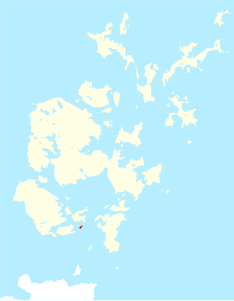
| Geographische Lage | 58° 47′ 59″ N, 3° 6′ 11″ W |
Contains Ordnance Survey data © Crown copyright and database right, CC BY-SA 3.0 | |
| Länge | 1,4 km |
| Breite | 580 m |
| Fläche | 41 ha |
| Höchste Erhebung | 28 m |
| Einwohner | unbewohnt |
Switha ist eine kleine, unbewohnte Felseninsel des schottischen Archipels Orkney, die außerhalb der Bucht von Scapa Flow, südlich der Insel Flotta und östlich der Halbinsel South Walls liegt.
Sie hat eine Fläche von 41 Hektar und erreicht ihre maximale Höhe von 28 Metern nahe der Steilküste im Süden. Sie ist 1400 Meter lang und maximal 580 Meter breit. Sie wird als Weideland für Schafe genutzt. Es gibt keine Aufzeichnungen darüber, ob die Insel je bewohnt war. Allerdings zeigen zwei Steinhügel und zwei Menhire (englisch Standing Stones) und dass die Insel in prähistorischen Zeiten besucht wurde. Beide Menhire sind klein, der eine ist etwa einen Meter hoch, 48 cm breit und an der Basis 15 cm dick; der andere ist etwa 1,4 m hoch, durchschnittlich 0,9 m breit und 12 cm dick und steht auf einem kleinen Hügel. Ein Hügel der Insel besteht aus mehreren großen Steinen. Von einem glaubt der Archäologe John Hunter, dass er ein umgefallener Menhir sein könnte.
Switha hat viele Sturmvogelhöhlen und ist Überwinterungsplatz für eine Kolonie von Nonnengänsen.
HMS Switha ist der Name eines als Ziel eingesetzten und 1981 gesunkenen Trawlers der Isles-Klasse.
Weblinks
Auf dieser Seite verwendete Medien
2007 Flag of Orkney
My own vector of the official flag of the Isles of Orkney, Scotland, created using Inkscape. This version is based upon the official version designed by Duncan Tullock of Birsay and voted for by the people of Orkney and approved by the Court of the Lord Lyon in 2007 from a short list of 5 designs. It is a Nordic Cross, in keeping with the flag's unofficial predecesor the Cross of St Magnus, and for which, according to Mr Tullock, "Orkney has always been represented by red, so that was an obvious choice. The yellow symbolizes the royal standards of both Scotland and Norway and blue is for Scotland, and also for the sea that surrounds us".
Contains Ordnance Survey data © Crown copyright and database right, CC BY-SA 3.0
Switha in Orkney
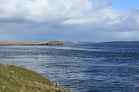
(c) Calum McRoberts, CC BY-SA 2.0
'Hells Gate' and Switha Calm today but when the tide is ebbing and a strong wind blowing the sea here is extremely treacherous. The sea-bed here changes in depth from 28 metres to 60 metres causing a big surge in water.
(c) Kelisi aus der englischsprachigen Wikipedia, CC BY-SA 3.0
A map of the Pentland Firth, northern Scotland, showing various towns and villages on the British mainland and in Orkney, as well as physical features, including islands in the Firth. This map's source is here, with the uploader's modifications, and the GMT homepage says that the tools are released under the GNU General Public License.


