Sutton Courtenay
| Sutton Courtenay | |||
|---|---|---|---|
| Koordinaten | 51° 39′ N, 1° 17′ W | ||
| OS National Grid | SU5094 | ||
| |||
| Traditionelle Grafschaft | Berkshire | ||
| Einwohner | 2413 (Stand: 2001) | ||
| Verwaltung | |||
| Post town | Abingdon | ||
| Vorwahl | 01235 | ||
| Landesteil | England | ||
| Shire county | Oxfordshire | ||
| Zeremonielle Grafschaft | Oxfordshire | ||
| Website: Sutton Courtenay | |||
Sutton Courtenay ist ein Ort und eine Zivilgemeinde an der Themse, drei Kilometer südlich von Abingdon und fünf Kilometer nordwestlich von Didcot. Bis 1974 gehörte Sutton Courtenay zu Berkshire, seit der Änderung der Grafschaftsgrenzen gehört es zu Oxfordshire.
Geschichte
- 688: König Ine von Wessex stattet das Kloster Abingdon mit der Grundherrschaft (Manor) Sutton aus.
- 801: Sutton wird königlich, lediglich Kirche und das Haus des Priesters verbleiben beim Kloster[1]
- 1086: Das Domesday Book verzeichnet, dass Sutton zur Hälfte dem König gehört
Der Namensbestandteil „Courtenay“ verweist darauf, dass Sutton ab dem Ende des 12. Jahrhunderts der Familie Courtenay gehörte.
Sehenswürdigkeiten
- Norman Hall (gebaut um 1192)[2] oder 1150[3]
- The Abbey, Sutton Courtenay (um 1280)
- Tudor Great Hall (14. Jahrhundert)
- The Wharf (errichtet 1913), Landsitz Herbert Henry Asquiths. Hier wurde Englands Eintritt in den Ersten Weltkrieg unterzeichnet.
- All Saint’s Church (12. Jahrhundert)[4]
- Friedhof mit den Gräbern von Eric Arthur Blair (George Orwell), Herbert Henry Asquith und David Astor
Persönlichkeiten
- Kaiserin Matilda (1102–1167) gebar ihr erstes Kind in Sutton[5]
- Violet Bonham Carter (1887–1969), Tochter Herbert Asquiths, war Besitzerin von Mill House
- Tim Burton (* 1958) und Helena Bonham Carter (* 1966) (Enkelin von Violet Bonham Carter)
- Jacques Goddet (1905–2000), Organisator der Tour de France, ging hier zur Schule
- Die Gartengestalterin Norah Lindsay (1873–1948) lebte ab 1894 mit ihrem Gatten in dem örtlichen Gutshaus.
 (c) Brian Robert Marshall, CC BY-SA 2.0Sutton Courtenay
 (c) Christine Matthews, CC BY-SA 2.0All Saint’s Church
 (c) Brian Robert Marshall, CC BY-SA 2.0Asquiths Grab
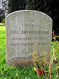 (c) Brian Robert Marshall, CC BY-SA 2.0Orwells Grab
Commons: Sutton Courtenay – Sammlung von Bildern, Videos und Audiodateien
Literatur
- William H. Page; P. H. Ditchfield: (Hrsg.) A History of the County of Berkshire, Band 4. Victoria County History (1924), S. 369–379.
- Nikolaus Pevsner: Berkshire. The Buildings of England. Harmondsworth: Penguin Books (1966) S. 235–237.
- David Nash Ford: „Sutton Courtenay Parish Church“ (2001) [2]
- David Nash Ford: „History of Sutton Courtenay, Berkshire (Oxfordshire)“ (2008)
Fußnoten
Auf dieser Seite verwendete Medien

Sutton Courtenay, Oxfordshire - geograph.org.uk - 362188.jpg
(c) Brian Robert Marshall, CC BY-SA 2.0
Sutton Courtenay, Oxfordshire (formerly Berkshire). The tower of All Saints' parish church is in the background and some cottages are in the foreground.
(c) Brian Robert Marshall, CC BY-SA 2.0
Sutton Courtenay, Oxfordshire (formerly Berkshire). The tower of All Saints' parish church is in the background and some cottages are in the foreground.

United Kingdom England adm location map.svg
(c) Karte: NordNordWest, Lizenz: Creative Commons by-sa-3.0 de
Positionskarte von England, Vereinigtes Königreich
(c) Karte: NordNordWest, Lizenz: Creative Commons by-sa-3.0 de
Positionskarte von England, Vereinigtes Königreich

All Saints Church, Sutton Courtenay - geograph.org.uk - 59576.jpg
(c) Christine Matthews, CC BY-SA 2.0
Church of England parish church of All Saints, Sutton Courtenay|Sutton Courtenay, Oxfordshire (formerly Berkshire), viewed from the south-east.
(c) Christine Matthews, CC BY-SA 2.0
Church of England parish church of All Saints, Sutton Courtenay|Sutton Courtenay, Oxfordshire (formerly Berkshire), viewed from the south-east.

Asquith's tomb, All Saints church, Sutton Courtenay - geograph.org.uk - 362223.jpg
(c) Brian Robert Marshall, CC BY-SA 2.0
Tomb of H. H. Asquith in All Saints' parish churchyard, Sutton Courtenay, Oxfordshire (formerly Berkshire)
(c) Brian Robert Marshall, CC BY-SA 2.0
Tomb of H. H. Asquith in All Saints' parish churchyard, Sutton Courtenay, Oxfordshire (formerly Berkshire)
%2c_All_Saints%2c_Sutton_Courtenay_-_geograph.org.uk_-_362277.jpg)
Grave of Eric Arthur Blair (George Orwell), All Saints, Sutton Courtenay - geograph.org.uk - 362277.jpg
(c) Brian Robert Marshall, CC BY-SA 2.0
Headstone of Eric Arthur Blair (George Orwell), in All Saints' parish churchyard, Sutton Courtenay, Oxfordshire (formerly Berkshire)
(c) Brian Robert Marshall, CC BY-SA 2.0
Headstone of Eric Arthur Blair (George Orwell), in All Saints' parish churchyard, Sutton Courtenay, Oxfordshire (formerly Berkshire)