Sungai Padas
| Padas | ||
 Photo by CEphoto, Uwe Aranas or alternatively © CEphoto, Uwe Aranas, CC BY-SA 3.0 Padas zwischen Beaufort und Tenom | ||
| Daten | ||
| Lage | Sabah, Borneo, Malaysia | |
| Flusssystem | Padas | |
| Quelle | im südwestlichen Sabah | |
| Mündung | Südchinesisches MeerKoordinaten: 5° 11′ 8″ N, 115° 33′ 50″ O 5° 11′ 8″ N, 115° 33′ 50″ O
| |
| Einzugsgebiet | 7720 km²[1] | |
| Linke Nebenflüsse | Sungai Pegalan, Sungai Pangi, Sungai Ketanum, Sungai Meligan, | |
| Rechte Nebenflüsse | Sungai Sunghi, Sungai Tomani, Pa Nagas | |
| Kleinstädte | Tenom, Beaufort | |
| Pegel in Tenom: 5° 7′ 0″ N, 115° 55′ 50″ O [2] | ||
 Padas mit Quell- und Nebenflüssen (dunkelblaue Einfärbung) | ||
Der Padas (mal. Sungai Padas) oder Padas River ist ein Fluss im malaysischen Bundesstaat Sabah auf Borneo. Er entspringt im südwestlichen Sabah, im Grenzgebiet zu Indonesien und Sarawak und verläuft aus dem Hochland bis zur Mündung bei Weston in die Padas-Bucht, die wiederum zum Südchinesischen Meer gehört. Im Mündungsgebiet mäandriert der Fluss stark. Der Padas mit seinen Quell- und Nebenflüssen entwässert ein Gebiet von 7720 km².[1]
Geologie
Etwa 20 % des Einzugsgebietes besteht aus Alluvialböden in Höhenlagen zwischen 200 und 600 m, weitere 60 % aus Hügeln und 20 % aus Gebirge mit Höhen bis zu 2600 m. Es herrschen sandiger Lehm, Sedimente und feine bis grobkörnige Sande vor. Der Süden und Osten besteht aus Sandstein und Tonstein, der Westen aus Schluffschiefer und massivem Sandstein, der Norden aus alluvialem Kies.[2] 22 % der Wassermenge des Sungai Padas entstammt dem Einzugsgebiet des Sungai Sook und strömt über den Sungai Pegalan dem Padas zu.[3]
Nutzung
Der Padas mit seinen Quell- und Nebenflüssen stellt das größte Flusssystem im Westen von Sabah dar. Der Unterlauf dient der Trinkwasserversorgung der Distrikte Beaufort und Tenom sowie dem Bundesterritorium Labuan. Außerdem wird in einer Staustufe unterhalb von Tenom Strom aus Wasserkraft für die Westküste Sabahs gewonnen.[4]
Zwischen Tenom und Beaufort verläuft der Fluss in der Padas-Schlucht. Dieser Flussabschnitt ist beliebt für Wildwasserrafting und Kajaktouren. Außerdem folgt die Bahnstrecke der Sabah State Railway dem Flusslauf. Für die Schluchtbewohner stellt die Eisenbahn die einzige infrastrukturelle Anbindung von Einzelhäusern und Siedlungen im straßenlosen Padas-Tal dar.
Galerie
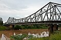 Photo by CEphoto, Uwe Aranas or alternatively © CEphoto, Uwe Aranas, CC BY-SA 3.0
Brücke über den Sungai Padas in Beaufort
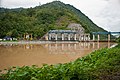 Photo by CEphoto, Uwe Aranas or alternatively © CEphoto, Uwe Aranas, CC BY-SA 3.0
Staustufe in der Nähe von Tenom am Eingang zur Padas-Schlucht

Wildwasserrafting in der Padas-Schlucht
Einzelnachweise
- ↑ a b Average Annual Surface Water Resources of Sabah and sarawak (PDF; 70 MB) Ministry of Natural Reserves and Environment, Water Resources Publications, Nr. 15, 1984, S. 33.
- ↑ a b Maria Seda: Environmental management in ASEAN: perspectives on critical regional issues. Institute of Southeast Asian, Singapur 1993, ISBN 981-3016-44-2, S. 137 (books.google.de).
- ↑ Field Site Description of Sook Plain (Seite nicht mehr abrufbar, festgestellt im Dezember 2018. Suche in Webarchiven) Info: Der Link wurde automatisch als defekt markiert. Bitte prüfe den Link gemäß Anleitung und entferne dann diesen Hinweis.
- ↑ Ulu Padas – Final Report. (PDF; 259 kB) Ministry of Culture, Environment and Tourism, 1998; abgerufen am 24. Januar 2012.
Auf dieser Seite verwendete Medien

Flag of the Malaysian state Sabah. Based on a GIF from a government website, colors from a photo. Drawn by Mysid. The flag was adopted September 16, 1988.
- The mountain on the left is Mount Kinabalu.
Per the Constitution of the State of Sabah:
"The State Flag is in a rectangular shape and is in the proportion of 1:2. The canton which extends at the head half way to the fly and 2/3 at the hoist to the foot is in Icicle Blue (C1T9) as the background to a graphic silhouette of Mount Kinabalu which is in Royal Blue (B10) positioned at ¼ of the height of the canton from end to end. The fly of the flag is divided equally into three bands of colours the foot division of which extends right to the hoist. The top band is in Zircon Blue (C5T5) the second band is in white and the third band is in Chili Red (S6R4)."Autor/Urheber: Cccefalon, Lizenz: CC BY-SA 3.0
Schematische Darstellung der Gewässer in Sabah, Malaysia: PADAS mit Quell- und Nebenflüssen

Photo by CEphoto, Uwe Aranas or alternatively © CEphoto, Uwe Aranas, CC BY-SA 3.0
Beaufort, Sabah, Malaysia: Bridge over Sungai Padas (Padas River) in Beaufort
Photo by CEphoto, Uwe Aranas or alternatively © CEphoto, Uwe Aranas, CC BY-SA 3.0
Sungai Padas (Padas River) between Beaufort and Tenom

Photo by CEphoto, Uwe Aranas or alternatively © CEphoto, Uwe Aranas, CC BY-SA 3.0
District Tenom, Sabah, Malaysia: Sungai Padas Barrage near Tenom at the entry of the gorge, also know as Pangi Hydroelectric Plant

Autor/Urheber: Smim90 at ms.wikipedia, Lizenz: GFDL
Aktiviti White Water Rafting di Sungai Padas.