Sungai Kinabatangan
| Sungai Kinabatangan | ||
 Kinabatangan mit Quell- und Nebenflüssen (dunkelblaue Einfärbung) | ||
| Daten | ||
| Lage | Sabah, Borneo, Malaysia | |
| Flusssystem | Kinabatangan | |
| Quelle | in der Landesmitte von Sabah | |
| Mündung | SuluseeKoordinaten: 5° 42′ 0″ N, 118° 23′ 0″ O 5° 42′ 0″ N, 118° 23′ 0″ O
| |
| Länge | 560 km[1] | |
| Einzugsgebiet | 16.800 km²[1] | |
| Großstädte | Sandakan | |
| Pegel in Balat: 5° 18′ 35″ N, 117° 35′ 50″ O[1] | ||
 Photo by CEphoto, Uwe Aranas or alternatively © CEphoto, Uwe Aranas, CC BY-SA 3.0 Kinabatangan an der Brücke nahe Batu Tugul | ||
Der Kinabatangan ist der größte Fluss des malaysischen Bundesstaates Sabah auf Borneo. Er entspringt in der Landesmitte von Sabah und verläuft stark mäandrierend aus dem Hochland bis zur Mündung in die Sulusee. Der Kinabatangan mit seinen Quell- und Nebenflüssen entwässert ein Gebiet von 16.800 km² – etwa ein Viertel des Bundesstaates Sabah. Im Tiefland bildet der Kinabatangan ein etwa 4000 Quadratkilometer großes Überschwemmungsgebiet, von dem 26.000 Hektar als Sanktuari Hidupan Liar di Hilir Kinabatangan (engl. „Kinabatangan Wildlife Sanctuary“) unter Naturschutz stehen.
Geologie
Das Umfeld im Oberlauf des Flusses besteht aus Bergen und Gebirgsgipfeln mit Höhenlagen zwischen 500 und 1500 m. Im Einzugsgebiet finden sich hauptsächlich Schichten von Tonstein, Schluffen, Sandstein und Kalkstein. Der Sandstein und die Schluffe sind generell wenig verfestigt. Die Böden sind sandig bis lehmig und in den Bergen in dünnen Schichten fein- bis grobsandig.[1]

Flora und Fauna
Das Gebiet umfasst tropische Auwälder, Altarm-Seen, Sumpfgebiete und Mangrovenwälder und gilt als eine Region von besonders hoher Biodiversität. Hier leben unter anderem Borneo-Orang-Utans, Nasenaffen, Borneo-Zwergelefanten, Sunda-Nebelparder sowie zahlreiche Vogel-, Reptilien-, Amphibien- und Fischarten. Im Unterlauf kommt der endemische Borneo-Flusshai (Glyphis fowlerae) vor.
Durch die zunehmende Besiedelung der Flussufer gelten diese Lebensräume als bedroht.
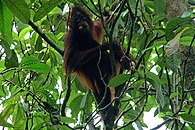 Orang Utan am Kinabatangan
 Sunda-Nebelparder am unteren Kinabatangan
 Nasenaffen am Kinabatangan
Literatur
- Nick Garbutt, J. Cede Prudente, David Attenborough: Wild Borneo: The Wildlife and Scenery of Sabah, Sarawak, Brunei, and Kalimantan. New Holland Publishers, London / Malaysia 2006, ISBN 1-84537-378-2.
- Managing Rivers Wisely: Kinabatangan Case Study (PDF; 132 kB), WWF Malaysia.
Weblinks
Einzelnachweise
- ↑ a b c d Maria Seda: Environmental management in ASEAN. Perspectives on critical regional issues. Institute of Southeast Asian Studies, Singapore 1993, ISBN 981-3016-44-2, S. 137 (books.google.de – Leseprobe).
Auf dieser Seite verwendete Medien
Autor/Urheber: Cccefalon, Lizenz: CC BY-SA 3.0
Schematische Darstellung der Gewässer in Sabah, Malaysia: KINABATANGAN mit Quell- und Nebenflüssen

Autor/Urheber: Matthias Bethke , Lizenz: CC BY-SA 4.0
Nasenaffen am Kinabatangan
Photo by CEphoto, Uwe Aranas or alternatively © CEphoto, Uwe Aranas, CC BY-SA 3.0
Kinabatangan, Sabah: Sungai Kinabatangan at the bridge near Batu Tulug

Autor/Urheber: Matthias Bethke , Lizenz: CC BY-SA 4.0
Orang Utan im Regenwald

Flag of the Malaysian state Sabah. Based on a GIF from a government website, colors from a photo. Drawn by Mysid. The flag was adopted September 16, 1988.
- The mountain on the left is Mount Kinabalu.
Per the Constitution of the State of Sabah:
"The State Flag is in a rectangular shape and is in the proportion of 1:2. The canton which extends at the head half way to the fly and 2/3 at the hoist to the foot is in Icicle Blue (C1T9) as the background to a graphic silhouette of Mount Kinabalu which is in Royal Blue (B10) positioned at ¼ of the height of the canton from end to end. The fly of the flag is divided equally into three bands of colours the foot division of which extends right to the hoist. The top band is in Zircon Blue (C5T5) the second band is in white and the third band is in Chili Red (S6R4)."Photo by CEphoto, Uwe Aranas or alternatively © CEphoto, Uwe Aranas, CC BY-SA 3.0
Kinabatangan, Sabah: Bridge over the Sungai Kinabatangan near Kg. Batu Putih

Autor/Urheber: www.photosbypaulo.com, Lizenz: CC BY-SA 3.0
Bornean Clouded Leopard (Neofelis diardi). Photo taken at the lower Kinabatangan River, eastern Sabah, Malaysia.