State Parks in Washington
Der US-Bundesstaat Washington unterhält 140 State Parks (Stand: Januar 2018)[1]. Die State Parks in Washington werden von der Washington State Parks and Recreation Commission verwaltet. Die ersten beiden Parks wurden 1915 ausgewiesen: der Chuckanut State Park (heute: Larrabee State Park) und ein Gebäude aus der Pionierzeit (heute: John R. Jackson House State Historic Site). Die Qualität und Flächengröße ist extrem unterschiedlich. Sie reicht vom Riverside State Park mit 5666 ha Flächengröße ist zum Blind Island State Park mit 1,2 ha. Wobei der Blind Island State Park schlicht ein Campingplatz am Meer ist.
Alphabetische Auflistung
- Alta Lake State Park
- Anderson Lake State Park
- Battle Ground Lake State Park
- Bay View State Park
- Beacon Rock State Park
- Belfair State Park
- Birch Bay State Park
- Blake Island State Park
- Blind Island State Park
- Bogachiel State Park
- Bottle Beach State Park
- Bridgeport State Park
- Bridle Trails State Park
- Brooks Memorial State Park
- Cama Beach State Park
- Camano Island State Park
- Camp Wooten Retreat Center
- Cape Disappointment State Park
- Centennial Trail State Park
- Clark Island State Park
- Columbia Hills State Park
- Columbia Plateau State Park Trail
- Conconully State Park
- Crawford State Park
- Curlew Lake State Park
- Cutts Island State Park
- Daroga State Park
- Dash Point State Park
- Deception Pass State Park
- Doe Island Marine State Park
- Dosewallips State Park
- Doug’s Beach State Park
- Eagle Island State Park
- Federation Forest State Park
- Fields Spring State Park
- Flaming Geyser State Park
- Fort Casey Historical State Park
- Fort Columbia Historical State Park
- Fort Ebey State Park
- Fort Flagler Historical State Park
- Fort Simcoe Historical State Park
- Fort Townsend Historical State Park
- Fort Worden Historical State Park
- Ginkgo Petrified Forest State Park/ Wanapum Recreation Area
- Goldendale Observatory State Park
- Grayland Beach State Park
- Griffiths-Priday State Park
- Hope Island State Park (Mason)
- Hope Island State Park (Skagit)
- Ike Kinswa State Park
- Illahee State Park
- Iron Horse State Park Trail
- Jackson House State Park Heritage Site
- James Island State Park
- Jarrell Cove State Park
- Joemma Beach State Park
- Jones Island State Park
- Joseph Whidbey State Park
- Kanaskat-Palmer State Park
- Kinney Point State Park
- Kitsap Memorial State Park
- Klickitat State Park Trail
- Kopachuck State Park
- Lake Chelan State Park
- Lake Easton State Park
- Lake Sammamish State Park
- Lake Sylvia State Park
- Lake Wenatchee State Park
- Larrabee State Park
- Leadbetter Point State Park
- Lewis & Clark State Park
- Lewis & Clark Trail State Park
- Lime Kiln Point State Park
- Lincoln Rock State Park
- Lyons Ferry Park
- Manchester State Park
- Maryhill State Park
- Matia Island State Park
- McMicken Island State Park
- Millersylvania State Park
- Moran State Park
- Mount Pilchuck State Park
- Mount Spokane State Park
- Mystery Bay State Park
- Nolte State Park
- Obstruction Pass State Park
- Ocean City State Park
- Olallie State Park
- Olmstead Place State Park
- Pacific Beach State Park
- Pacific Pines State Park
- Palouse Falls State Park
- Paradise Point State Park
- Patos Island State Park
- Peace Arch Historical State Park
- Pearrygin Lake State Park
- Penrose Point State Park
- Peshastin Pinnacles State Park
- Pleasant Harbor State Park
- Posey Island State Park
- Potholes State Park
- Potlatch State Park
- Rainbow Falls State Park
- Rasar State Park
- Reed Island State Park
- Riverside State Park/ Nine Mile Recreation Area
- Rockport State Park
- Sacajawea State Park
- Saddlebag Island Marine State Park
- Saint Edward State Park
- Saltwater State Park
- Scenic Beach State Park
- Schafer State Park
- Seaquest State Park
- Sequim Bay State Park
- Shine Tidelands State Park
- Skagit Island State Park
- South Whidbey State Park
- Spencer Spit State Park
- Spring Creek Hatchery State Park
- Squak Mountain State Park
- Squilchuck State Park
- Steamboat Rock State Park
- Steptoe Battlefield State Park
- Steptoe Butte State Park
- Stuart Island State Park
- Sucia Island State Park
- Sun Lakes-Dry Falls State Park
- Tolmie State Park
- Triton Cove State Park
- Turn Island State Park
- Twanoh State Park
- Twenty-Five Mile Creek State Park
- Twin Harbors State Park
- Wallace Falls State Park
- Wenatchee Confluence State Park
- Westhaven State Park
- Westport Light State Park
- Willapa Hills State Park Trail
- Yakima Sportsman State Park
Galerie
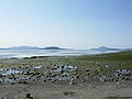 Bay View State Park
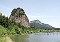

 (c) I, Jonathan Zander, CC BY-SA 3.0

 Personenzug von 1925 im Iron Horse State Park Trail
 Leuchtturm am Lime Kiln Point
 (c) Joe Mabel, CC BY-SA 3.0Moran State Park
 (c) I, Murderbike, CC BY-SA 3.0


Ehemalige State Parks
Aufgrund Budgetkürzungen wurden einige Parks aus dem System der State Parks herausgelöst.
- Central Ferry State Park – Central Ferry Park
- Chief Timothy State Park – Chief Timothy Park
- Crow Butte State Park – Crow Butte Park
- Damon Point State Park – Damon Point
- Fay Bainbridge State Park – Fay Bainbridge Park
- Fort Okanogan State Park – Fort Okanogan
- Fort Ward State Park – Fort Ward Park
- Griffin Bay State Park – Green River Gorge Conservation Area
- Hanging Gardens State Park
- Mukilteo State Park – Mukilteo Lighthouse Park
- Osoyoos Lake State Park
- Upright Channel State Park
- Wenberg State Park – Wenberg County Park
- West Hylebos State Park – West Hylebos Wetlands Park
Einzelnachweise
- ↑ State Parks Sitemap - Geographische und Alphabetische Liste. Washington State Parks, abgerufen am 26. Januar 2018.
Weblinks
Alabama | Alaska | Arizona | Arkansas | Colorado | Connecticut | Delaware | Florida | Georgia | Hawaii | Idaho | Illinois | Indiana | Iowa | Kalifornien | Kansas | Kentucky | Louisiana | Maine | Maryland | Massachusetts | Michigan | Minnesota | Mississippi | Missouri | Montana | Nebraska | Nevada | New Hampshire | New Jersey | New Mexico | New York | North Carolina | North Dakota | Ohio | Oklahoma | Oregon | Pennsylvania | Rhode Island | South Carolina | South Dakota | Tennessee | Texas | Utah | Vermont | Virginia | Washington | West Virginia | Wisconsin | Wyoming
Auf dieser Seite verwendete Medien


Autor/Urheber: Benjamin Cody, Lizenz: CC BY-SA 3.0
North Beach at Fort Worden State Park, Port Townsend, Washington


(c) I, Jonathan Zander, CC BY-SA 3.0
Foto Fort Casey der verschwindenen Gewehr auf Whidbey Insel, Washington, USA.

Autor/Urheber: Benjamin Cody, Lizenz: CC BY-SA 3.0
View of Padilla Bay from Bayview State Park; Bay View, Washington

Autor/Urheber: Die Autorenschaft wurde nicht in einer maschinell lesbaren Form angegeben. Es wird Rewinn als Autor angenommen (basierend auf den Rechteinhaber-Angaben)., Lizenz: CC BY-SA 2.5
Description: Entrance to Ginkgo/Wanapum State Park, Washington State, USA; shows entrance sign and large chunk of petrified wood. Source: own work Date of Creation: November 17, 2006
Author: Randy Winn (myself)
Autor/Urheber: Arnold C (User:Buchanan-Hermit), Lizenz: Attribution
United States side of the Peace Arch monument. Blaine, Washington, USA.


(c) I, Murderbike, CC BY-SA 3.0
The Bowl and Pitcher formation at Riverside State Park, Spokane, Washington

(c) Joe Mabel, CC BY-SA 3.0
Observation tower, Mt. Constitution, Moran State Park, Orcas Island, Washington, USA. The 53-foot sandstone tower, reinforced with 2 tons of steel, measures 18 x 28 feet at the base. It was designed by architect Ellsworth Storey and built in 1935–36 by members of the Civilian Conservation Corps.
Beacon rock