State Parks in Georgia
Dies ist eine Liste der State Parks im US-Bundesstaat Georgia.


A
- A.H. Stephens Historic Park in Crawfordville, GA
- Amicalola Falls State Park in Dawsonville, Dawson County
B
- Black Rock Mountain State Park in Mountain City, GA
- Bobby Brown State Park in Elberton, GA
C
- Chief Vann House Historic Site in Chatsworth, GA
- Cloudland Canyon State Park in Rising Fawn, GA
- Crooked River State Park in St. Marys, Camden County
D
- Dahlonega Gold Museum Historic Site in Dahlonega, Lumpkin County
E
- Elijah Clark State Park in Lincolnton, GA
- Etowah Indian Mounds Historic Site in Cartersville, Bartow County
F
- F.D. Roosevelt State Park in Pine Mountain, GA
- Florence Marina State Park in Omaha, GA
- Fort King George Historic Site in Darien, McIntosh County
- Fort McAllister Historic Park in Richmond Hill, GA
- Fort Mountain State Park in Chatsworth, GA
- Fort Yargo State Park in Winder, GA
G
- General Coffee State Park in Nicholls, GA
- George L. Smith State Park in Twin City, GA
- George T. Bagby State Park in Fort Gaines, GA
- Georgia Veterans State Park in Cordele, GA
- Gordonia-Alatamaha State Park in Reidsville, Tattnall County
H
- Hamburg State Park in Mitchell, GA
- Hard Labor Creek State Park in Rutledge, GA
- Hart State Park in Hartwell, GA
- High Falls State Park in Jackson, GA
- Hofwyl-Broadfield Plantation Historic Site in Brunswick, Glynn County
I
- Indian Springs State Park in Flovilla, GA
J
- James H. "Sloppy" Floyd State Park in Summerville, GA
- Jarrell Plantation Historic Site in Juliette, GA
- Jefferson Davis Memorial Historic Site in Fitzgerald, Ben Hill County
- John Tanner State Park in Carrollton, GA
K
- Kolomoki Mounds Historic Park in Blakely, GA
L
- Lapham-Patterson House Historic Site in Thomasville, GA
- Laura S. Walker State Park in Waycross, GA
- Little Ocmulgee State Park in McRae, GA
- Little White House Historic Site in Warm Springs, Meriwether County
M
- Magnolia Springs State Park in Millen, GA
- Mistletoe State Park in Appling, GA
- Moccasin Creek State Park in Clarkesville, GA
N
- New Echota Historic Site in Calhoun, GA
P
- Panola Mountain State Park in Stockbridge, GA
- Pickett’s Mill Battlefield Historic Site in Dallas, Paulding County
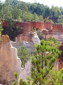
- Providence Canyon State Park in Lumpkin, GA
R
- Red Top Mountain State Park in Cartersville, Bartow County
- Reed Bingham State Park in Adel, Cook County
- Richard B. Russell State Park in Elberton, GA
- Robert Toombs House Historic Site in Washington, Wilkes County
S
- Sapelo Island Reserve and Reynolds Mansion in Darien, McIntosh County
- Seminole State Park in Donalsonville, GA
- Skidaway Island State Park in Savannah, Chatham County
- Smithgall Woods Conservation Area in Helen, GA
- Sprewell Bluff State Park in Thomaston, GA
- Stephen C. Foster State Park in Fargo, GA
- Sweetwater Creek State Park in Lithia Springs, GA
T
- Tallulah Gorge State Park in Tallulah Falls, GA
- Travelers Rest Historic Site in Toccoa, GA
- Tugaloo State Park in Lavonia, GA
U
- Unicoi State Park in Helen, GA
V
- Victoria Bryant State Park in Royston, GA
- Vogel State Park in Blairsville, Union County
W
- Watson Mill Bridge State Park in Comer, GA
- Wormsloe Historic Site in Savannah, Chatham County
Weblinks
Commons: State Parks in Georgia – Sammlung von Bildern, Videos und Audiodateien
Auf dieser Seite verwendete Medien
GA-Veterans-SP-1.jpg
Tanks on display at Georgia Veterans State Park near Cordele, Georgia, USA. 31°57′32″N 83°54′41″W / 31.95889°N 83.91139°W
Tanks on display at Georgia Veterans State Park near Cordele, Georgia, USA. 31°57′32″N 83°54′41″W / 31.95889°N 83.91139°W
USA-Georgia-Etowah Indian Mounds-Mound B.jpg
Autor/Urheber: Kåre Thor Olsen, Lizenz: CC BY-SA 3.0
Mound B at the archaeological site Etowah Indian Mounds in Georgia, USA
Autor/Urheber: Kåre Thor Olsen, Lizenz: CC BY-SA 3.0
Mound B at the archaeological site Etowah Indian Mounds in Georgia, USA
Providence-Canyon-SP-GA-2.jpg
Providence Canyon State Park near Lumpkin, Georgia, USA. 32°4′13″N 84°54′47″W / 32.07028°N 84.91306°W
Providence Canyon State Park near Lumpkin, Georgia, USA. 32°4′13″N 84°54′47″W / 32.07028°N 84.91306°W
Cloudland Waterfall 2.jpg
Photo by R. McClenny
Photo by R. McClenny
Jane Hurt Yarn Interpretive Center, Tallulah Gorge State Park.JPG
Autor/Urheber: FloNight (Sydney Poore) and Russell Poore, Lizenz: CC BY-SA 4.0
Jane Hurt Yarn Interpretive Center, Tallulah Gorge State Park
Autor/Urheber: FloNight (Sydney Poore) and Russell Poore, Lizenz: CC BY-SA 4.0
Jane Hurt Yarn Interpretive Center, Tallulah Gorge State Park


