Stac Pollaidh
| Stac Pollaidh Stack Polly | ||
|---|---|---|
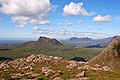
 Stac Pollaidh, von Süden gesehen, mit Loch Lurgainn im Vordergrund | ||
| Höhe | 613 m ASL | |
| Lage | Highland, Schottland | |
| Schartenhöhe | 438 m | |
| Koordinaten | 58° 2′ 38″ N, 5° 12′ 22″ W | |
| ||
| Gestein | Sandstein | |
Der Stac Pollaidh (im Englischen oft zu Stack Polly verballhornt) ist ein Berg in Schottland. Er ist als Graham und Marilyn eingestuft und liegt in der Council Area Highland auf der Halbinsel Coigach nördlich von Ullapool in der dünn besiedelten Region Wester Ross, Teil der ehemaligen Grafschaft Ross-shire. Sein gälischer Name kann in etwa mit Steiler Fels des Teichs übersetzt werden.[1] Trotz seiner relativ geringen Höhe ragt der Berg markant über seine Umgebung hinaus und ist aufgrund der Aussicht wie auch des kurzen Zustiegs ein beliebtes Ziel für Wanderer.[2] Zu erreichen ist der Stac Pollaidh über eine von der A835 nördlich von Ullapool abzweigende Single track road in Richtung Achiltibuie.
Vom Parkplatz nördlich des Loch Lurgainn ist der Zustieg über markierte Pfade in etwa zwei Stunden möglich. Während der Ostgipfel auch für Wanderer gut erreichbar ist, erfordert der etwas höhere Westgipfel Kletterei über die Sandsteinfelsen des Gipfelaufbaus. Der Berg gilt daher als einer der schwierigsten Gipfel des britischen Festlands.[3]
Im Jahr 2004 legte eine Telekommunikationsfirma Pläne für einen Sendemast auf dem Stac Pollaidh vor. Nach heftiger öffentlicher Kritik wurden diese Pläne aufgegeben.[4]
 (c) Stephen Branley, CC BY-SA 2.0
Der Stac Pollaidh von Süden, im Hintergrund rechts der Suilven
 (c) michael hardman, CC BY-SA 2.0
Blick vom östlich benachbarten Cùl Mòr zum Stac Pollaidh
 (c) Gordon Hatton, CC BY-SA 2.0
Der Stac Pollaidh von Nordwesten gesehen
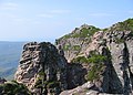 (c) Richard Webb, CC BY-SA 2.0
Felsen auf dem Gipfelgrat des Stac Pollaidh
Einzelnachweise
- ↑ Peter Drummond: Scottish Hill and Mountain Names: The Origin and Meaning of the Names of Scotland’s Hills and Mountains, Scottish Mountaineering Trust, 2010, ISBN 978-0-907521-95-2, S. 57
- ↑ Auf den Stac Pollaidh. Outdoor Magazin, 25. September 2012.
- ↑ Stac Pollaidh ridge and circuit. Walkhighland (englisch).
- ↑ Stac Pollaidh escapes march of the masts. The Scotsman, [28. Juli 2004] (englisch).
Weblinks
Auf dieser Seite verwendete Medien

(c) michael hardman, CC BY-SA 2.0
Stac Pollaidh from Cul Mor. Looking waste from the South West of the Cul Mor summit. In the distance is Loch Broom and the Summer Isles

(c) Gordon Hatton, CC BY-SA 2.0
Loch Buine Mor and Stac Pollaidh The view across the loch towards Stac Pollaidh, which looks quite different [and maybe a little less dramatic] from this angle.

(c) Stephen Branley, CC BY-SA 2.0
Stac Pollaidh Taken from the south of Loch Lurgainn with Stac Pollaidh mid picture and Mt Suilven beyond.

(c) Richard Webb, CC BY-SA 2.0
Stac Pollaidh, Summit. The actual ridge of Stac Pollaidh. The summit is not so often visited due to the pinnacle on the left which is an easy but very intimidating scramble involving down climbing over big drops.

Contains Ordnance Survey data © Crown copyright and database right, CC BY-SA 3.0
Relief map of Highland, UK.
Equirectangular map projection on WGS 84 datum, with N/S stretched 180%
Geographic limits:
- West: 6.9W
- East: 2.9W
- North: 58.8N
- South: 56.4N
Autor/Urheber: Mehmet Karatay, Lizenz: CC BY-SA 3.0
Stac Pollaidh from the south, showing Loch Lurgainn in the foreground