Brandungspfeiler

Brandungspfeiler sind vor einer Kliffküste aufragende Felsentürme und vergleichbare Formationen, die durch Brandungserosion gebildet wurden. Sie entstehen durch Einsturz von Brandungstoren oder Abtrennung von Brandungsgassen, vor allem in Landschaften, wo felsige Bergzüge bis ins Meer reichen.
Beispiele
Der einzige Brandungspfeiler in Deutschland ist die „Lange Anna“ vor der Insel Helgoland. Dessen Name auf Helgoländer Friesisch, Nathurn Stak (‚Nordhorn-Brandungspfeiler‘), ist verwandt mit der englischen Bezeichnung stack und der schottisch-gälischen Bezeichnung stac. In Schottland findet man Brandungspfeiler beispielsweise als Bestandteil des St.-Kilda-Archipels (Stac an Armin, Stac Lee), wo sie aus Resten eines tertiären Vulkankegels gebildet wurden, beim Old Man of Hoy, Old Man of Stoer, beim Dunnicaer Hillfort oder auf den Flannan Isles. Kleinere Brandungspfeiler findet man rund um die Farne-Inseln im Nordosten Englands.
- Brandungspfeiler
 „Lange Anna“ vor Helgoland
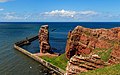
 (c) Shaun Ferguson, CC BY-SA 2.0Old Harry’s Rocks
 (c) Charles W Glynn, CC BY-SA 2.0Loop Head
 (c) Allyson Taylor, CC BY-SA 2.0Elugug, Wales
 Grotte aux pigeons Libanon
 (c) C. Michael Hogan, CC BY-SA 2.0Lingavi Geo, Shapinsay (Orkneyinseln)
 (c) David Lewis, CC BY-SA 2.0Linney Head
 Dún Briste Irland
 Old Man of Hoy, Hoy (Orkney)
Siehe auch
Literatur
- Dieter Kelletat: Physische Geographie der Meere und Küsten. Eine Einführung, Springer Fachmedien, Wiesbaden 1989, ISBN 3-519-03426-3.
Weblinks
- Anthropogen beeinflusste Landschaftsentwicklung im Osten der Osterinsel. (PDF) geographie.uni-kiel.de; abgerufen am 2. September 2019.
- Zusammenfassung Geologie. (PDF; 0,4 MB) skriptweb.de; abgerufen am 2. September 2019.
Auf dieser Seite verwendete Medien

(c) Allyson Taylor, CC BY-SA 2.0
Stack Rocks - Elugug Stacks. These sea stacks lie just to the east of the Green Bridge of Wales. They provide a safe nesting ground for sea birds.

(c) C. Michael Hogan, CC BY-SA 2.0
Sea stack at southern edge of Lingavi Geo, Shapinsay east coast. With seabirds on cliffs and shoreline rocks.

(c) Grinner aus der englischsprachigen Wikipedia, CC BY-SA 3.0
en:Old Man of Hoy. Taken by en:User:Grinner on 16 October 2005.
en:Category:Stacks
Autor/Urheber: Gunther Tschuch, Lizenz: CC BY-SA 4.0
Downpatrick Head, Mayo Co., Ireland

(c) Charles W Glynn, CC BY-SA 2.0
Loop Head. Diarmuid and Graine's Rock or Lover's Leap at Loop Head, Co. Clare. The rock layers are mostly sandstone with subordinate interbedded shale. The rocks are part of the Ross Formation of Carboniferous (Namurian) age.
Autor/Urheber: Islandhopper, Lizenz: CC BY-SA 3.0
Küstenformen Schottlands

Autor/Urheber: A.Savin, Lizenz: FAL
Aussicht über Lummenfelsen und Lange Anna auf Helgoland, Deutschland


Autor/Urheber: Gaël FROUIN, Lizenz: FAL
Rawché (also called pigeons cave in French) is well known for the numerous suicides that were committed in the area

(c) Shaun Ferguson, CC BY-SA 2.0
Old Harry's Rocks Old Harry's Rocks Studland Bay

(c) David Lewis, CC BY-SA 2.0
Coastal stack, east of Linney Head, S. Pembrokeshire.