St Mary’s (Scilly-Inseln)
| St Mary’s | ||
|---|---|---|
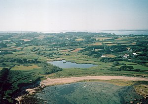
| St Mary’s aus der Luft betrachtet | ||
| Gewässer | Keltische See | |
| Inselgruppe | Scilly-Inseln | |
| Geographische Lage | 49° 55′ 25″ N, 6° 17′ 50″ W | |
| ||
| Länge | 3,9 km | |
| Breite | 2,9 km | |
| Fläche | 6,29 km² | |
| Höchste Erhebung | Mount Todden 36 m ASL | |
| Einwohner | 1666 (2001) 265 Einw./km² | |
| Hauptort | Hugh Town | |
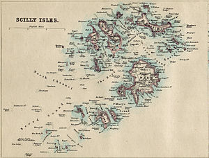
| Scilly-Inseln auf historischer Karte von 1874 | ||
St Mary’s (kornisch: Ennor) ist die größte Insel der Scilly-Inseln. Die Hauptstadt Hugh Town wurde 1949 vom Vereinigten Königreich an die hiesige Bevölkerung verkauft. Der Rest der Insel gehört zum Herzogtum Cornwall. Weitere Siedlungen auf St Mary’s sind Old Town, Porthloo, Holy Vale, Maypole, Rocky Hill und Telegraph. Die Insel wurde auch die Heimat des britischen Premierministers Harold Wilson, der 1995 dort begraben wurde. Mit dem St Mary’s Airport befindet sich auf St Mary’s auch der wichtigste Flughafen der Inselgruppe.
Sehenswürdigkeiten
- Bant’s Carn, bronzezeitliches Grab auf einem Hügel oberhalb von Halangy Down
- Carn Gwavel, Souterrain, auf privatem Grund
- Halangy Down, Eisenzeitdorf
- Porth Hellick Down, Entrance Grave des Typs “Scillonian entrance graves”
Weblinks
Auf dieser Seite verwendete Medien
Contains Ordnance Survey data © Crown copyright and database right, CC BY-SA 3.0
Blank map of the Isles of Scilly, UK with districts shown.
Equirectangular map projection on WGS 84 datum, with N/S stretched 150%
Geographic limits:
- West: 6.45W
- East: 6.23W
- North: 49.99N
- South: 49.86N
Autor/Urheber: Daniel Bagshaw, Lizenz: CC BY-SA 2.5
St Mary's, Isles of Scilly, Cornwall. As seen from the helicopter.


