St John’s Loch
| St John’s Loch | ||
|---|---|---|
(c) Ken Walton, CC BY-SA 2.0 | ||
| Blick über St John’s Loch | ||
| Geographische Lage | Highland, Schottland | |
| Abfluss | Burn of Dunnet → Dunnet Bay | |
| Orte am Ufer | Dunnet | |
| Ufernaher Ort | Thurso | |
| Daten | ||
| Koordinaten | 58° 37′ 50″ N, 3° 20′ 10″ W | |
| ||
| Höhe über Meeresspiegel | 25 m ASL[1] | |
| Fläche | 78 ha[1] | |
| Länge | 1,3 km[2] | |
| Breite | 910 m[2] | |
| Volumen | 1.098.700 m³ [1] | |
| Umfang | 4 km[1] | |
| Maximale Tiefe | 2,1 m[1] | |
| Mittlere Tiefe | 1,4 m[1] | |
| Einzugsgebiet | 3,56 km²[1] | |
St John’s Loch ist ein Süßwassersee in der schottischen Council Area Highland beziehungsweise der traditionellen Grafschaft Caithness.[3] Er liegt am Hals der Halbinsel Dunnet Head rund elf Kilometer östlich von Thurso nur einen Kilometer östlich der Küste der Dunnet Bay.
Beschreibung
Der See liegt auf einer Höhe von 25 Metern über dem Meeresspiegel.[1] St John’s Loch weist eine Länge von 1,3 Kilometern bei einer maximalen Breite von 910 Metern auf[2], woraus sich eine Fläche von 78 Hektar und ein Umfang von vier Kilometern ergeben.[1] Der flache See besitzt ein Volumen von 1.098.700 Kilolitern. Das Einzugsgebiet von St John’s Loch beträgt 356 Hektar. Der See besitzt eine durchschnittliche Tiefe von 1,4 Metern und eine maximale Tiefe von 2,1 Metern.[1] Am Westufer fließt der kleine Burn of Dunnet ab, der jenseits von Dunnet in die Dunnet Bay entwässert.
St John’s Loch besitzt eine Forellen-Population. Der örtliche Anglerverein betreibt dort auch eine Forellenzucht.[3] Entlang dem Südufer verläuft die A836.
Einzelnachweise
Auf dieser Seite verwendete Medien
(c) Ken Walton, CC BY-SA 2.0
St John's Loch near Dunnet Head. St John's is a shallow loch, one of the best known in Caithness. Most of its fishing is by boat, for trout. It has the distinction of supporting the most northerly hatch of Mayfly in the British Isles. This picture was taken at 9:45 p.m. on July 1, 2004 and people were still fishing there.
Contains Ordnance Survey data © Crown copyright and database right, CC BY-SA 3.0
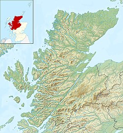
Relief map of Highland, UK.
Equirectangular map projection on WGS 84 datum, with N/S stretched 180%
Geographic limits:
- West: 6.9W
- East: 2.9W
- North: 58.8N
- South: 56.4N


