St. Paul’s (St. Helena)
| St. Paul’s | |||
|---|---|---|---|
| |||
| Koordinaten | 15° 57′ 5″ S, 5° 43′ 21″ W | ||
 | |||
| Basisdaten | |||
| Staat | St. Helena, Ascension und Tristan da Cunha | ||
| Insel St. Helena | |||
| ISO 3166-2 | SH-HL | ||
| Fläche | 11,4 km² | ||
| Einwohner | 928 (2021) | ||
| Dichte | 81,4 Ew./km² | ||
St. Paul’s ist ein Distrikt und eine Ansiedlung auf St. Helena. Der Distrikt St. Paul’s hat 928 Einwohner (Stand 2021)[1] auf einer Fläche von 11,4 Quadratkilometern.
Neben der gleichnamigen Hauptansiedlung befinden sich mit Francis Plain und Scotland zwei weitere Ansiedlungen in dem Distrikt. Mit der Schule Prince Andrew hat St. Paul’s die einzige weiterführende Schule der Insel.
Touristisches
St. Paul’s ist einer der touristisch wichtigsten Distrikte der Insel. Hier befinden sich unter anderem:
- Plantation House, der Sitz des Gouverneurs von St. Helena
- St. Paul’s Cathedral
- High Knoll Fort
- Prince’s Lodge
- Lemon Valley, ein historisches Landschaftsschutzgebiet
- Jonathan, ältester Bewohner der Insel und das älteste lebende Reptil der Welt
- Farm Lodge Hotel, eine touristische Unterkunft
Francis Plain verfügt über den einzigen Cricket- und Fußballplatz der Insel.
Sakralbauten
- St. Paul’s Cathedral
- St. Martin-in-the-Hills Church
- St Helena Baptist Church
- Knollcombe Chapel mit dem Buren-Krieg-Friedhof
Galerie

St. Paul’s Cathedral

Plantation House
Prince Andrew-Schule
High Knoll Fort
High Knoll Fort
 (c) Peter Neaum, CC BY 3.0
St. Martin-in-the-Hills Church

Knollcombe Chapel
Weblinks
- St Paul’s; St Helena Island. Topographische Karte 1:20.000. In: gis-sthelena.gov.sh, Geospatial Information, Mapping and Survey Systems (GIS) St Helena (PDF; 162 kB, englisch).
- St Pauls – the heartland of St Helena. Informationsseite mit Fotos. In: Saint Helena Island Info: All about St Helena, in the South Atlantic Ocean. John Turner (englisch).
- In & around St Paul’s. Offizielle touristische Informationen. In: Explore St Helena – Visitor Guide. St Helena Tourism, Januar 2014, S. 21 (PDF; 3,86 MB, englisch).
Einzelnachweise
Auf dieser Seite verwendete Medien
.jpg)
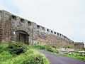
High Knoll Fort Gate (16438343441).jpg
Autor/Urheber: David Stanley from Nanaimo, Canada, Lizenz: CC BY 2.0
High Knoll Fort (1874) on a hilltop in the center of St Helena Island was well protected by high stone walls. The most dangerous Boer prisoners were held here during the Anglo-Boer War.
Autor/Urheber: David Stanley from Nanaimo, Canada, Lizenz: CC BY 2.0
High Knoll Fort (1874) on a hilltop in the center of St Helena Island was well protected by high stone walls. The most dangerous Boer prisoners were held here during the Anglo-Boer War.

The Anglican Church of St Martin’s in the Hills, Thompson's Hill, St Helena Island, South Atlantic Ocean. Photo circa 1985. Peter Neaum. - panoramio.jpg
(c) Peter Neaum, CC BY 3.0
The Anglican Church of St Martin’s in the Hills, Thompson's Hill, St Helena Island, South Atlantic Ocean. Photo circa 1985. Peter Neaum.
(c) Peter Neaum, CC BY 3.0
The Anglican Church of St Martin’s in the Hills, Thompson's Hill, St Helena Island, South Atlantic Ocean. Photo circa 1985. Peter Neaum.

Baptist Church in Knollcombes front.jpg
Autor/Urheber: Kevstan, Lizenz: CC BY-SA 4.0
a small brown stone church with an open bell steeple and small vestibule at the front entrance
Autor/Urheber: Kevstan, Lizenz: CC BY-SA 4.0
a small brown stone church with an open bell steeple and small vestibule at the front entrance
.jpg)
Plantation House (16431883766).jpg
Autor/Urheber: David Stanley from Nanaimo, Canada, Lizenz: CC BY 2.0
Since its construction by the East India Company in 1792, Plantation House at White Gate has been the residence of the governors of St Helena Island.
Autor/Urheber: David Stanley from Nanaimo, Canada, Lizenz: CC BY 2.0
Since its construction by the East India Company in 1792, Plantation House at White Gate has been the residence of the governors of St Helena Island.
.jpg)
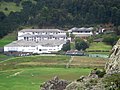
Prince Andrew School (16264718467).jpg
Autor/Urheber: David Stanley from Nanaimo, Canada, Lizenz: CC BY 2.0
Prince Andrew School at Francis Plain, St Helena Island, is the island's only secondary school.
Autor/Urheber: David Stanley from Nanaimo, Canada, Lizenz: CC BY 2.0
Prince Andrew School at Francis Plain, St Helena Island, is the island's only secondary school.
District map of Saint Helena.png
Autor/Urheber: Maximilian Dörrbecker (Chumwa), Lizenz: CC BY-SA 3.0
Karte Distrikte auf St. Helena
Autor/Urheber: Maximilian Dörrbecker (Chumwa), Lizenz: CC BY-SA 3.0
Karte Distrikte auf St. Helena

Atlantic Ocean laea location map.svg
Autor/Urheber: Tentotwo, Lizenz: CC BY-SA 3.0
Relief location map of Atlantic_Ocean.
Autor/Urheber: Tentotwo, Lizenz: CC BY-SA 3.0
Relief location map of Atlantic_Ocean.
- Projection: Lambert azimuthal equal-area projection.
- Area of interest:
- N: 70.0° N
- S: -70.0° N
- W: -95.0° E
- E: 25.0° E
- Projection center:
- NS: 0.0° N
- WE: -35.0° E
- GMT projection: -JA-35.0/0.0/180/19.998266666666666c
- GMT region: -R-147.58842045747764/-48.58942183011819/77.58842045747762/48.589421830118205r
- Land, shoreline and borders: 1:110m Natural Earth Datasets
.jpg)
St Paul's Anglican Cathedral (16468521732).jpg
Autor/Urheber: David Stanley from Nanaimo, Canada, Lizenz: CC BY 2.0
St Paul's Anglican Cathedral (1851) stands at White Gate near the governor's residence on St Helena Island. Local military, civil, and clerical dignitaries are buried in the surrounding cemetery.
Autor/Urheber: David Stanley from Nanaimo, Canada, Lizenz: CC BY 2.0
St Paul's Anglican Cathedral (1851) stands at White Gate near the governor's residence on St Helena Island. Local military, civil, and clerical dignitaries are buried in the surrounding cemetery.
.jpg)
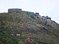
High Knoll Fort (16253357747).jpg
Autor/Urheber: David Stanley from Nanaimo, Canada, Lizenz: CC BY 2.0
High Knoll Fort at Redhill once served as the citadel of last refuge for the inhabitants of St Helena Island. The tower was built in 1798 and the outer walls and gate completed in 1874.
Autor/Urheber: David Stanley from Nanaimo, Canada, Lizenz: CC BY 2.0
High Knoll Fort at Redhill once served as the citadel of last refuge for the inhabitants of St Helena Island. The tower was built in 1798 and the outer walls and gate completed in 1874.