Sonoita (Arizona)
| Sonoita | |
|---|---|
 | |
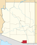
| Lage im Santa Cruz County und in Arizona | |
| Basisdaten | |
| Staat: | Vereinigte Staaten |
| Bundesstaat: | Arizona |
| County: | Santa Cruz County |
| Koordinaten: | 31° 41′ N, 110° 39′ W |
| Zeitzone: | Mountain Standard Time (UTC−7) |
| Einwohner: | 803 (Stand: 2020) |
| Haushalte: | 288 (Stand: 2020) |
| Fläche: | 118,1 km² (ca. 46 mi²) davon 118,1 km² (ca. 46 mi²) Land |
| Bevölkerungsdichte: | 7 Einwohner je km² |
| Höhe: | 1489 m |
| Postleitzahl: | 85637 |
| Vorwahl: | +1 520 |
| FIPS: | 04-68220 |
| GNIS-ID: | 0034635 |
Sonoita ist ein Census-designated place im Santa Cruz County im Süden des US-Bundesstaates Arizona. Das U.S. Census Bureau hat bei der Volkszählung 2020 eine Einwohnerzahl von 803[1] ermittelt.
Sonoita liegt nahe der Grenze zum Pima County und ist etwa 35 Kilometer von der amerikanisch-mexikanischen Grenze entfernt. Die Gemeinde liegt nahe dem Knotenpunkt Arizona State Route 82 und Arizona State Route 83. Sonoita hat eine Fläche von 118,1 km². Die Bevölkerungsdichte liegt bei 7 Einwohnern je km².
Weblinks
Einzelnachweise
- ↑ Explore Census Data Sonoita CDP, Arizona. Abgerufen am 23. Oktober 2022.
Auf dieser Seite verwendete Medien
Locator map of Santa Cruz County in southern Arizona.
(c) DemocraticLuntz in der Wikipedia auf Englisch, CC BY-SA 4.0
Location of Sonoita in Santa Cruz County, Arizona.
FIPS code: 04-68220
Own work, based on concept by Arkyan, using Census Bureau Tiger GIS data and a custom fork of Kartography adapted for this purpose, available atAutor/Urheber: Bill Morrow, Lizenz: CC BY 2.0
The rolling hills of southern Arizona. It was near this location that the TV series
LITTLE HOUSE ON THE PRAIRIE was filmed.


