Smythe Shoulder
| Smythe Shoulder | ||
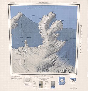
 Topografische Karte der Martin-Halbinsel mit der Smythe Shoulder (rechts der Mitte) | ||
| Geographische Lage | ||
| Koordinaten | 74° 18′ 0″ S, 113° 53′ 0″ W | |
| Lage | Walgreen-Küste, Marie-Byrd-Land, Westantarktika | |
| Gewässer 1 | Dotson-Schelfeis | |
| Gewässer 2 | Singer-Gletscher | |
| Gewässer 3 | Rydelek-Eisfälle | |
Die Smythe Shoulder ist eine vereiste, und bis zu 450 m hohe Halbinsel an der Walgreen-Küste des westantarktischen Marie-Byrd-Lands. Auf der Ostseite der Martin-Halbinsel ragt sie zwischen dem Singer-Gletscher und den Rydelek-Eisfällen in das Dotson-Schelfeis.
Der United States Geological Survey kartierte sie anhand eigener Vermessungen und Luftaufnahmen der United States Navy aus den Jahren von 1959 bis 1967 sowie Landsat-Aufnahmen aus den Jahren von 1973 bis 1973. Das Advisory Committee on Antarctic Names benannte sie 1977 nach dem Geophysiker William Smythe von der University of California, Los Angeles, der im Rahmen des United States Antarctic Research Program zur Besetzung auf der Amundsen-Scott-Südpolstation im antarktischen Winter des Jahres 1975 gehört hatte.
Weblinks
- Smythe Shoulder im Geographic Names Information System des United States Geological Survey (englisch)
- Smythe Shoulder auf geographic.org (englisch)
Auf dieser Seite verwendete Medien
Autor/Urheber: Alexrk2, Lizenz: CC BY-SA 3.0
Physische Positionskarte Antarktis, Mittabstandstreue Azimutalprojektion
1:250,000-scale topographic reconnaissance map of the Martin Peninsula area from 112°30'-117°W to 73°45'-75°S in Antarctica, including the eastern parts of the Getz Ice Shelf and the western parts of Dotson Ice Shelf. Mapped, edited and published by the U.S. Geological Survey in cooperation with the National Science Foundation.


