Sliabh Mis
| Sliabh Mis (Slieve Mish Mountains) | ||
|---|---|---|
 (c) Andreas F. Borchert, CC BY-SA 4.0 Ruinen des Augustinerklosters St. Mary de Bello Loco vor der Südseite des Sliabh Mis | ||
| Höhe | 851 m | |
| Lage | County Kerry, Irland | |
| Koordinaten | 52° 11′ 0″ N, 9° 55′ 0″ W | |
| ||
| Typ | Gebirgszug | |
| Gestein | Sandstein | |
Der Sliabh Mis (Aussprache: [ˈʃlʲiːəvʲ mʲiʃ], irisch für Berg Mis, engl. Slieve Mish Mountains) ist ein Sandstein-Gebirgszug im County Kerry in Irland. Der Name wird von einer wegen ihrer Grausamkeit berüchtigten mythischen Prinzessin hergeleitet.
Geographie
Sliabh Mis liegt auf der Dingle-Halbinsel zwischen Tralee-Bay (irisch Loch Foirdhreamhain / Cuan Thrá Lí) im Norden und der Dingle-Bay (Bá an Daingin) im Süden. Er erstreckt sich in einer Länge von ungefähr 19 km von Ost nach West. Er bildet die Landenge der Dingle-Halbinsel, die mit 7 km relativ schmal ist. Die Struktur des Sliabh Mis wurde in der letzten Eiszeit durch Gletscher geformt, es entstanden Trogtäler und Kar-Seen. Von den vielen Gipfeln tragen nur wenige einen Namen, wie Glanbrack Mountain (664 m), Gearhane (An Géarán, 792 m), als höchster der Baurtregaum (Barr Trí gCom, 851 m), sowie der Caherconree (Cathair Conraoi, 835 m) mit dem gleichnamigen Promontory Fort in einer Höhe von 625 m. Es bewacht die Bergstraße Bóthar na gCloch („Straße der Steine“) und ist einer der bedeutenden mythischen Plätze im County Kerry.
Der Sliabh Mis in Kerry darf nicht mit dem Slemish (irisch ebenfalls Sliabh Mis) in der Nähe von Ballymena im County Antrim verwechselt werden.
Mythologie
Als die Milesier die Landung in Irland gegen den Widerstand der Túatha Dé Danann zum zweiten Male erzwungen hatten, marschierten sie nach Tara und forderten dort die Túatha zum Kampf heraus. Drei Tage nach dieser Landung trafen die Milesier auf einen Teil der Truppen bei Sliabh Mis. Die Túatha wurde vernichtend geschlagen und flohen. Bei Tailtiu (Teltown), einer Stadt im County Meath, fand schließlich die letzte Schlacht statt und die Túatha mussten für immer in die Síds zurückweichen.
Bildergalerie
 (c) Adrian Platt, CC BY-SA 2.0
Bóthar na gCloch
 (c) Adrian Platt, CC BY-SA 2.0
Moorlandschaft
 (c) Colin Park, CC BY-SA 2.0
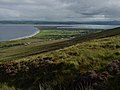
Tralee-Bay
 (c) Colin Park, CC BY-SA 2.0
Bautregaum-Gipfel
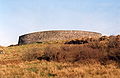
Cahergal/Caherconree Ringfort
Weblinks
Auf dieser Seite verwendete Medien
(c) Andreas F. Borchert, CC BY-SA 4.0
South range of Killagh Priory with the Slieve Mish Mountains in the background.

(c) Colin Park, CC BY-SA 2.0
On the lower slopes of Gearhane, Slieve Mish On the lower slopes of Gearhane in the Slieve Mish Mountains. This view looks towards the spit of land on the south side of Tralee Bay. Walking on this slope is not easy due to the uneven ground and tussocky grass.


(c) Adrian Platt, CC BY-SA 2.0
Road over Slieve Mish Mountains This is the Castlemaine to Clahane road that crosses the Slieve Mish Mountains, taken near Clahane. The town of Tralee is spread out in the valley beyond.

(c) Adrian Platt, CC BY-SA 2.0
Slieve Mish moorlands This road links Castlemaine to the south of the Slieve mish Mountains to Clahane and Tralee to the north. The top is an area of peaty moorlands as seen here. The hill in the centre is an outlier of Knockawaddra.

(c) Colin Park, CC BY-SA 2.0
A foggy day on the summit of Baurtregaum, Slieve Mish The trig point on Baurtregaum, the highest point on the Slieve Mish Mountains. I had ascended from Killelton via Gearhane and Caherconree, an excellent ridge walk if I could have seen it but it was all in thick mist.
