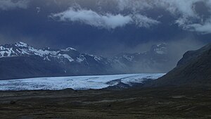
Skaftafellsjökull
| Skaftafellsjökull | ||
|---|---|---|
Skaftafellsjökull | ||
| Lage | Island | |
| Koordinaten | 64° 1′ N, 16° 55′ W | |
| Entwässerung | Skaftafellsá | |
 Skaftafellsjökull und Hvannadalshnjúkur | ||
 Aschewolke des Grímsvötn-Ausbruchs 2011 über dem Skaftafellsjökull | ||
Der Skaftafellsjökull ist eine 10 Kilometer lange und knapp 2,5 Kilometer breite Gletscherzunge des Vatnajökull in Island.
Lage
Er liegt im Vatnajökull-Nationalpark, genauer im ehemaligen Skaftafell-Nationalpark zwischen der Skaftafellsheiði im Westen und dem Hafrafell im Osten.
Abfluss
Unterhalb des Gletschers befindet sich ein Gletschersee von unterschiedlicher Größe. Aus ihm strömt der kleine Fluss Skaftafellsá, der in die Skeiðará mündet.
Weblinks
Auf dieser Seite verwendete Medien
Looking from the Skaftafell National Park to the Hvannadalshnjúkur of the Öræfajökull. Skaftafellsjökull with its icelagoon in the front followed by the Svínafellsjökull at the right.
Autor/Urheber: Calistemon, Lizenz: CC BY-SA 3.0
Darkened sky and ash cloud descending through the Skaftafellsjoekull glacier approx. four hours after the Grímsvötn 2011 eruption, 21 May, as seen from the Foss Hotel at Skaftafell.
Autor/Urheber: Qaswed, Lizenz: CC BY-SA 4.0
Traces of Skaftafellsjökull (rightmost in the picture) in the rocks document its shrinkage.
Autor/Urheber:
- Iceland_location_map.svg: NordNordWest
- derivative work: Виктор В (talk)
Positionskarte von Island
(c) Chris 73 / Wikimedia Commons, CC BY-SA 3.0
Gletscher im Skaftafell National Park, Island 2005.


