Sittingbourne
| Sittingbourne | |||
|---|---|---|---|
 (c) John Salmon, CC BY-SA 2.0 | |||
| Koordinaten | 51° 20′ N, 0° 44′ O | ||
| OS National Grid | TQ905635 | ||
| |||
| Einwohner | 59.000 (Stand: 2010) | ||
| Verwaltung | |||
| Post town | SITTINGBOURNE | ||
| Postleitzahlenabschnitt | ME9, ME10 | ||
| Vorwahl | 01795 | ||
| Landesteil | England | ||
| Region | South East England | ||
| Shire county | Kent | ||
| District | Borough of Swale | ||
| Britisches Parlament | Sittingbourne and Sheppey | ||
Sittingbourne ist eine Stadt im Norden der Grafschaft Kent in England. Es ist Hauptort und Verwaltungssitz des Borough of Swale, zählt ca. 59.000 Einwohner (Stand: 2010) und liegt verkehrsgünstig an der Autobahn M2 und der vierspurig ausgebauten A249 etwa 60 km Luftlinie von London entfernt südlich der Isle of Sheppey, von der sie durch den Kanal The Swale getrennt wird.
Siedlungsspuren lassen sich bis etwa 2000 v. Chr. nachweisen (Kelten). Die Watling Street, eine im ersten nachchristlichen Jahrhundert gebaute quer durch Britannien verlaufende Römerstraße, führte durch diesen Ort.
 (c) John Salmon, CC BY-SA 2.0
St. Michael in Sittingbourne
 (c) John Salmon, CC BY-SA 2.0
Ostfenster St. Michael mit Darstellung des letzten Abendmahls
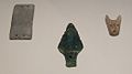
Funde aus einem kupfersteinzeitlichen Grab (2500 bis 2100 v. Chr.) bei Sittingbourne; von links nach rechts: eine steinerne Armschutzplatte, ein Kupferdolch, ein Gürtelbeschlag
Söhne und Töchter der Stadt
- Aaron Beeney (* 1984), Dartspieler
Weblinks
Auf dieser Seite verwendete Medien
(c) John Salmon, CC BY-SA 2.0
High Street, Sittingbourne

Autor/Urheber: JMiall, Lizenz: CC BY-SA 3.0
A Copper age grave group featuring
1)stone wristguard 2)copper dagger 3)bone belt fitting
found at Sittingbourne, now in the British Museum
(c) John Salmon, CC BY-SA 2.0
St Michael, Sittingbourne, Kent - East window The Last Supper

Autor/Urheber:
- United Kingdom location map.svg: NordNordWest
- England Regions - Blank.svg: Ch1902
- Northern Ireland location map.svg: NordNordWest
- Europe laea location map.svg: Alexrk2
- Spischot
Positionskarte von England

(c) John Salmon, CC BY-SA 2.0
St Michael, Sittingbourne, Kent