Sindhupalchok
| सिन्धुपाल्चोक जिल्ला Distrikt Sindhupalchok | |
|---|---|
(c) Karte: NordNordWest, Lizenz: Creative Commons by-sa-3.0 de Lage des Distriktes Sindhupalchok (rot) in Nepal | |
| Basisdaten | |
| Staat | Nepal |
| Provinz | Bagmati |
| Sitz | Chautara |
| Fläche | 2542 km² |
| Einwohner | 287.798 (Volkszählung 2011) |
| Dichte | 113 Einwohner pro km² |
| ISO 3166-2 | NP-P3 |
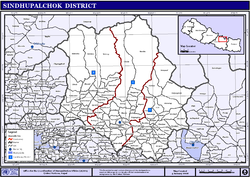
| VDCs und Städte (blau) in Sindhupalchok | |
Der Distrikt Sindhupalchok (Nepaliसिन्धुपाल्चोक जिल्ला) ist einer von 77 Distrikten in Nepal und gehört seit der Verfassung von 2015 zur Provinz Bagmati.
Er liegt östlich von Kathmandu und lag bis 2015 in der Verwaltungszone Bagmati. Bei der Volkszählung 2011 hatte Sindhupalchok 287.798 Einwohner.[1]
Verwaltungsgliederung
Städte im Distrikt Sindhupalchok:
- Chautara
- Melamchi
Village Development Committees (VDCs) im Distrikt Sindhupalchok:
- Atarpur
- Badegau
- Balephi
- Banskharka
- Baramchi
- Barhabise
- Baruwa
- Batase
- Bhimtar
- Bhote Namlang
- Bhotechaur
- Bhotsiba
- Chaukati
- Dhumthang
- Dhuskun
- Dubarchaur
- Gati
- Ghorthali
- Gloche
- Gumba
- Gunsakot
- Hagam
- Haibung
- Helambu
- Ichok
- Irkhu Bhanjyang
- Jalbire
- Jethal
- Kadambas
- Kalika
- Karkhali
- Kiwul
- Kunchok
- Langarche
- Lisankhu
- Listikot
- Mahankal
- Maneswar
- Mankha
- Marming
- Motang
- Nawalpur
- Pagretar
- Palchok
- Pangtang
- Petaku
- Phulping Katti
- Phulpingdandagau
- Phulpingkot
- Piskar
- Ramche
- Sangachok
- Selang
- Sipa Pokhare
- Sipal Kavre
- Sunkhani
- Syaule Bazar
- Tatopani
- Tauthali
- Tekanpur
- Thakani
- Thampal Dhap
- Thangpalkot
- Thokarpa
- Thulo Dhading
- Thulo Pakhar
- Thulo Sirubari
- Thum Pakhar
- Timpul Ghyangul
- Yamandanda
Weblinks
Einzelnachweise
- ↑ Household and population by districts, Central Bureau of Statistics (CBS) Nepal (Memento vom 31. Juli 2013 im Internet Archive) (PDF; 2,1 MB)
Auf dieser Seite verwendete Medien
Map displaying Village Development Committees in Sindhupalchok District, Nepal
(c) Karte: NordNordWest, Lizenz: Creative Commons by-sa-3.0 de
Distrikt Sindhupalchok in Nepal, Stand 2015


