Sigguup Nunaa
| Sigguup Nunaa | ||
 Lage von Sigguup Nunaa und anderen geographischen Objekten der Gegend | ||
| Geographische Lage | ||
| Koordinaten | 71° 53′ N, 54° 25′ W | |
| Gewässer 1 | Baffin Bay | |
| Gewässer 2 | Atlantischer Ozean | |
| Länge | 75 km | |
| Breite | 75 km | |
| Fläche | 4 500 km² | |
Sigguup Nunaa (historisch Nunavik; dänisch Svartenhuk Halvø) ist eine grönländische Halbinsel in der Avannaata Kommunia.
Geografie
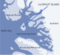
Sigguup Nunaa bildet die Grenze zwischen dem Distrikt Upernavik im Norden und dem Distrikt Uummannaq im Süden. Die aus Basalt bestehende Halbinsel hat eine Fläche von rund 4500 km² und misst sowohl in Nord-Süd- als auch in West-Ost-Richtung rund 75 km.[1] Die nördliche und westliche Grenze bildet der lange Fjord Umiiarfik, die östliche der Fjord Ukkusissat Sulluat. Vor der Südküste liegt der Karrat Fjord. Mehrere breite, aber kurze Fjord schneiden in Sigguup Nunaa, dies sind im Uhrzeigersinn Kangiusap Imaa, Umiiviup Kangerlua, Tasiusap Imaa mit Arfertuarsuk, Maligiaq (Svartenhavn), Milloorfik und Amitsup Ilua.[2]
Geschichte
Im 17. oder 18. Jahrhundert benannten holländische Walfänger die Ostspitze der Halbinsel Zwarte Hoek („Schwarze Ecke“), woraus der dänische Name Svartenhuk wurde. Der grönländische Name des Kaps lautet Sigguk („Schnauze, Schnabel“), worauf sich der offizielle Name der Halbinsel bezieht (nuna „Land“). Daneben war auch der Name Nunavik („echtes Land“) gebräuchlich.[1]
An der Küste der Halbinsel wurden nur wenige Spuren früherer Besiedelung gefunden. 1794 wurde der Udsted Kakilisaat an der Südostküste gegründet, der bereits 1797 nach Naqerloq auf Illorsuit versetzt wurde.[3]
Einzelnachweise
- ↑ a b Rasmus Ole Rasmussen: Svartenhuk. Den Store Danske.
- ↑ Nunat Aqqi. Karte über die vom Grönländischen Ortsnamenausschuss offiziell anerkannten Ortsnamen. Oqaasileriffik.
- ↑ Nunniffiit (Karte der archäologischen Fundstellen in Grönland). Grönländisches Nationalmuseum und -archiv.
Auf dieser Seite verwendete Medien
Autor/Urheber: Uwe Dedering, Lizenz: CC BY-SA 3.0
Relief location map of Greenland.
- Projection: EquiDistantConicProjection.
- Area of interest:
- N: 85.0° N
- S: 59.0° N
- W: -75.0° E
- E: -10.0° E
- Projection center:
- NS: 72.0° N
- WE: -42.5° E
- Standard parallels:
- 1: 64.0° N
- 2: 80.0° N
- GMT projection: -JD-42.5/72/64/80/20c
- GMT region: -R-60.16/57.61/24.5/79.91r
- GMT region for grdcut: -R-120.24/57.61/24.5/85.78r
- Relief: SRTM30plus.
- Made with Natural Earth. Free vector and raster map data @ naturalearthdata.com.
Autor/Urheber: Algkalv (talk), Lizenz: CC BY-SA 3.0
Location of Illorsuit Island within the Uummannaq Fjord area, Greenland. Sketch map.


