Selenge-Aimag
| Selenge-Aimag Сэлэнгэ Аймаг | |
|---|---|
 Wappen des Selenge-Aimag | Flagge des Selenge-Aimag |
(c) Aineias, CC-BY-SA-3.0 Der Selenge-Fluss im Selenge-Aimag | |
| Gegründet: | 1934 |
| Hauptort: | Süchbaatar |
| Fläche: | 41.100 km² |
| Einwohner: | 106.677 (2016) |
| Bev.-dichte: | 2,6 Einw./km² |
| Telefonvorwahl: | +976 (0)136 |
| KFZ-Kennzeichen: | СЭ_ |
| ISO 3166-2: | MN-049 |
| Offiz. Website: | www.selenge.mn/ |
| Lage des Selenge-Aimag in der Mongolei | |
Koordinaten: 50° 12′ N, 106° 12′ O
Der Selenge-Aimag (mongolisch Сэлэнгэ Аймаг) ist ein Aimag (Provinz) der Mongolei, an der nördlichen Grenze des Landes gelegen.
In den Selenge-Aimag ist als Enklave der Darchan-Uul-Aimag eingebettet.
Administrative Gliederung
| Sum | Mongolisch | Bevölkerung (2000) | Bevölkerung (2002) | Bevölkerung (2004) | Bevölkerung (2006) | Bevölkerung (2008) | Fläche (km²)[2] | Dichte (/km²) |
|---|---|---|---|---|---|---|---|---|
| Altanbulag | Алтанбулаг | 3.489 | 4.003 | 3.783 | 4.255 | 4.545 | 2100,30 | 2,16 |
| Baruunbüren | Баруунбүрэн | 2.939 | 2.430 | 2.430 | 2.378 | 2.702 | 2814,54 | 0,96 |
| Bajangol | Баянгол | 5.391 | 5.015 | 4.264 | 4.512 | 5.028 | 1976,28 | 2,54 |
| Chüder | Хүдэр | 1.799 | 1.772 | 1.838 | 1.936 | 2.078 | 2838,65 | 0,73 |
| Chuschaat | Хушаат | 1.406 | 1.679 | 1.946 | 1.654 | 1.585 | 2010,15 | 0,79 |
| Dschawchlant | Жавхлант | 1.767 | 1.921 | 1.838 | 1.704 | 1.827 | 1189,70 | 1,54 |
| Jeröö | Ерөө | 6.077 | 5.677 | 5.531 | 5.630 | 5.792 | 8203,51 | 0,71 |
| Mandal | Мандал | 23.964 | 22.645 | 22.864 | 22.975 | 23.646 | 4843,73 | 4,88 |
| Orchon | Орхон | 2.817 | 2.467 | 2.106 | 2.006 | 2.165 | 1306,27 | 1,66 |
| Orchonnuur | Орхоннуур | 2.817 | 2.467 | 2.106 | 2.006 | 2.165 | 1306,27 | 1,66 |
| Saichan | Сайхан | 8.737 | 8.795 | 8.282 | 8.100 | 8.285 | 1311,87 | 6,32 |
| Sant | Сант | 2.062 | 2.050 | 2.033 | 2.054 | 2.056 | 1387,06 | 1,48 |
| Schaamar | Шаамар | 4.809 | 4.157 | 3.783 | 3.944 | 4.158 | 671,91 | 6,19 |
| Süchbaatar | Сүхбаатар | 22.374 | 21.076 | 20.025 | 19.916 | 19.626 | 45,35 | 432,77 |
| Tüschig | Тшиг | 1.899 | 1.725 | 1.608 | 1.552 | 1.420 | 2492,82 | 0,57 |
| Tsagaannuur | Цагааннуур | 4.153 | 4.221 | 3.919 | 4.005 | 4.257 | 3814,72 | 1,12 |
| Tsüünbüren | Зүүнбүрэн | 2.507 | 2.226 | 2.373 | 2.201 | 2.468 | 1204,94 | 2,05 |
Einzelnachweise
- ↑ Selenge Aimag Statistical Office. Selenge Aimag Sums Review 2000-2008Archivierte Kopie (Memento des Originals vom 22. Juli 2011 im Internet Archive) Info: Der Archivlink wurde automatisch eingesetzt und noch nicht geprüft. Bitte prüfe Original- und Archivlink gemäß Anleitung und entferne dann diesen Hinweis. (MS Excel; 193 kB)
- ↑ Official site of the Selenge aimagArchivierte Kopie (Memento des Originals vom 18. November 2007 im Internet Archive) Info: Der Archivlink wurde automatisch eingesetzt und noch nicht geprüft. Bitte prüfe Original- und Archivlink gemäß Anleitung und entferne dann diesen Hinweis.
Auf dieser Seite verwendete Medien
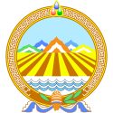
Coat of Arms of the Selenge Aimag in Mongolia, from 1999.
Official blason, from the resolution no. 40 of 1999-12-24 by the aimag khural:
- At the basis, an upright conch shell horn
- Wrapped in a khadag
- Flanked by evergreen leaves
- The Mountains of Khan-Uul in the background
- Fields in the middle
- Stylized waves of the Selenge river at the bottom
- A circular enclosure with crossing meanders
- Crowned by the three wish fullfilling jewels
Autor/Urheber: TUBS
Lage des Aimags XY (siehe Dateiname) in der Mongolei.
(c) English Wikipedia Benutzer Bogomolov.PL, CC-BY-SA-3.0
Map of the Selenge aimag with the sums
(c) Aineias, CC BY-SA 3.0
Die Selenga ca. 100-200 km von der russischen Grenze Wann: 9.2005
Flag of the Selenge Aimag in Mongolia, from 1999.
Official blason, from the resolution no. 40 of 1999-12-24 by the aimag khural:
- The flag should be flown from a yellow pole with a trident on top (not shown)
- Blue color for the eternal sky
- Two bands of waves for the river giving fertility
- A vertical grain spike for the fruits of the land
- Thre red tassels for three "wise men" of the aimag


