Scott-Küste
| Scott-Küste | ||
|---|---|---|
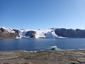
Francisco Ardini / ©PNRA, CC BY-SA 4.0 Tethys Bay im nördlichen Küstenabschnitt unweit des Kap Washington | ||
| Lage | Viktorialand, Ostantarktika | |
| Gewässer | Rossmeer | |
| Von | Kap Washington 74° 39′ 0″ S, 165° 25′ 0″ O | |
| Bis | Minna Bluff 78° 34′ 30″ S, 167° 4′ 20″ O | |
 | ||
Koordinaten: 77° S, 163° O
Die Scott-Küste ist ein Küstenabschnitt entlang des McMurdo-Sunds im ostantarktischen Viktorialand, der sich zwischen Kap Washington im Norden und dem Minna Bluff im Süden erstreckt. Im Norden schließt sich die Borchgrevink-Küste an, und im Süden die Hillary-Küste. Sie liegt weitgehend am offenen Rossmeer, reicht aber im Süden in das Ross-Schelfeis hinein.
Das New Zealand Antarctic Place-Names Committee benannte die Küste nach dem britischen Polarforscher Robert Falcon Scott (1868–1912), Leiter der Discovery-Expedition (1901–1904) und der Terra-Nova-Expedition (1911–1913), unter dessen Führung der größte Teil dieser Küste erkundet und zahlreiche geographische Objekte benannt wurden.
Weblinks
- Scott Coast auf geographic.org (englisch)
- Scott Coast. In: Geographic Names Information System. United States Geological Survey, United States Department of the Interior, archiviert vom (englisch).
Auf dieser Seite verwendete Medien
Autor/Urheber: Alexrk2, Lizenz: CC BY-SA 3.0
Physische Positionskarte Antarktis, Mittabstandstreue Azimutalprojektion
Francisco Ardini / ©PNRA, CC BY-SA 4.0
Tethys Bay, Ross Sea, Antarctica
Just days away from the beginning of the Southern Hemisphere’s spring, Antarctica’s Inexpressible Island and the Northern Foothills Mountains were illuminated by a glimmer of sunlight from a low angle when the Advanced Land Imager (ALI) on NASA’s Earth Observing-1 (EO-1) satellite captured this image on September 16, 2009. The seaward slopes of the mountains are gleaming white, and they cast long shadows inland over the Nansen Ice Sheet. Terra Nova Bay appears in shadow.
The scene provides at least two indications of the bay’s persistent and fierce katabatic winds—downslope winds that blow from the interior of the ice sheet toward the coast. One is the windswept ground in the mountainous terrain. In many places, there is a pattern of bare rock and snow drifts that suggests the winds have scoured snow from upwind (inland-facing) slopes and deposited it on the lee sides.
The second sign of the strong winds appears in the open waters of Terra Nova Bay. Parallel white streamers are composed of newly formed sea ice, probably frazil—crystals just millimeters wide—and congealed frazil, called “grease ice” because it resembles an oil slick on the water. The ice is continually pushed out to sea by the strong offshore winds, leaving a pocket of open water, a polynya.


