Schlammvulkane von Poto

 (c) Karte: NordNordWest, Lizenz: Creative Commons by-sa-3.0 de
| |
Poto in Oe-Cusse Ambeno |
Die Schlammvulkane von Poto (Area Poto Mud Volcano) bilden eine Fläche von Schlammvulkanen im osttimoresischen Suco Bobometo (Verwaltungsamt Oesilo, Sonderverwaltungsregion Oe-Cusse Ambeno).[1] Sie befinden sich südlich vom Dorf Saben, nahe der Grenze zu Indonesien. Eine Straße führt an dem Gelände vorbei.
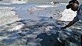

 Das Plakat warnt vor giftigen Gasen
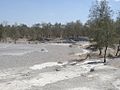
Literatur
- Frederico Santos, José Manuel Pereira, António de Jesus Araújo: Mud volcano in East Timor: Constituent materials, the process, the geological structure and its interpretation, 2012.
Weblinks
Commons: Schlammvulkane von Poto – Sammlung von Bildern, Videos und Audiodateien
Einzelnachweise
- ↑ District Profile Oecussi Enclave, Democratic Republic of East Timor. Ministry of State Administration, Government of Timor-Leste, S. 3, 2002 (englisch);estatal.gov.tl ( des vom 5. September 2014 im Internet Archive) Info: Der Archivlink wurde automatisch eingesetzt und noch nicht geprüft. Bitte prüfe Original- und Archivlink gemäß Anleitung und entferne dann diesen Hinweis. (PDF; 687 kB).
Koordinaten: 9° 21′ 43,9″ S, 124° 22′ 37,9″ O
Auf dieser Seite verwendete Medien
East Timor adm-2 location map.svg
(c) Karte: NordNordWest, Lizenz: Creative Commons by-sa-3.0 de
Positionskarte von Osttimor
(c) Karte: NordNordWest, Lizenz: Creative Commons by-sa-3.0 de
Positionskarte von Osttimor

2020-08-08 Oesilo Schlammvulkane 2.jpg
Die Schlammvulkane in Oesilo, Osttimor. Mitarbeiter des Zivilschutz hängen ein Plakat mit Warnhinweisen auf.
Die Schlammvulkane in Oesilo, Osttimor. Mitarbeiter des Zivilschutz hängen ein Plakat mit Warnhinweisen auf.

2020-08-08 Oesilo Schlammvulkane 3.jpg
Die Schlammvulkane in Oesilo, Osttimor.
Die Schlammvulkane in Oesilo, Osttimor.

2020-08-08 Oesilo Schlammvulkane 1.jpg
Die Schlammvulkane in Oesilo, Osttimor.
Die Schlammvulkane in Oesilo, Osttimor.
2020-08-08 Oesilo Schlammvulkane 4.jpg
Die Schlammvulkane in Oesilo, Osttimor.
Die Schlammvulkane in Oesilo, Osttimor.

Casuarina trees at mud volcano landscape at Oesilo, Oecusse District, Timor-Leste.jpg
Autor/Urheber: Colin Trainor, Lizenz: CC BY-SA 3.0
Casuarina trees at mud volcano landscape at Oesilo, Oecusse District, Timor-Leste
Autor/Urheber: Colin Trainor, Lizenz: CC BY-SA 3.0
Casuarina trees at mud volcano landscape at Oesilo, Oecusse District, Timor-Leste