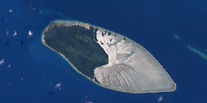
Sassie Island
| Sassie Island (Long Island) | ||
|---|---|---|
 | ||
| Gewässer | Pazifischer Ozean | |
| Geographische Lage | 10° 2′ 6″ S, 142° 50′ 53″ O | |
| Länge | 5,1 km | |
| Breite | 2,9 km | |
| Fläche | 10,07 km² | |
| Höchste Erhebung | 8 m | |
| Einwohner | unbewohnt | |
Sassie Island, auch als Long Island bekannt, ist eine Insel in der Mitte der Torres Strait, einer Wasserstraße zwischen Australien und Papua-Neuguinea. Die 10,07 km² große Insel schließt sich im Westen an das mit 19,67 km² fast doppelt so große Korallenriff Sassie Reef an.
Sassie ist eine Koralleninsel, die acht Meter über die Wasseroberfläche ragt.[1] Sie ist die größte Insel der Central Islands, vor Zagai. Die nächstgelegene bewohnte Insel ist Yam Island 14 km nordwestlich. Ebenfalls nahe gelegen sind Sue Island (17 km südlich) und Coconut Island (21 km östlich). Die zu Sassie Island nächstgelegene Insel außerhalb des Sassie Reef ist jedoch die unbewohnte Bet Island 11 km südlich.
Auf der Riffplattform des Sassie Reef liegen im Osten von Sassie Island noch zahlreiche weitere kleine Inseln, die alle unbenannt sind. Die kleinsten Inseln weisen nur wenige Meter im Durchmesser auf, während die größte Insel unmittelbar (wenige Meter) nordöstlich von Sassie Island eine Fläche von rund 1,5 Hektar erreicht.
Siehe auch
Einzelnachweise
- ↑ Royal Geographical Society: Central Strait Islands -Queensland by Degrees ( des vom 18. März 2012 im Internet Archive) Info: Der Archivlink wurde automatisch eingesetzt und noch nicht geprüft. Bitte prüfe Original- und Archivlink gemäß Anleitung und entferne dann diesen Hinweis.
Auf dieser Seite verwendete Medien
Autor/Urheber: Uwe Dedering, Lizenz: CC BY-SA 3.0
Location map of Queensland, Australia
Equirectangular projection, N/S stretching 106 %. Geographic limits of the map:
- N: 9.0° S
- S: 29.5° S
- W: 137.5° E
- E: 154.0° E
Sassie Island, Central Group of Torres Strait Islands, Queensland, Australia
(c) Kelisi aus der englischsprachigen Wikipedia, CC BY-SA 3.0
A map of the Torres Strait Islands. I have endeavoured to use native names wherever I could find them. If you can suggest ways in which this map could be made more up to date, don't hesitate to leave me a message to that effect.
This map's source is here, with the uploader's modifications, and the GMT homepage says that the tools are released under the GNU General Public License.


