Santa Fe National Forest
Santa Fe National Forest IUCN-Kategorie VI – Protected Area with Sustainable use of Natural Resources | ||
 (c) Aaron Zhu, CC BY-SA 3.0 Die Battleship Rocks im Santa Fe National Forest | ||
| Lage | New Mexico, USA | |
| Fläche | 6.800,6 km²[1] | |
| Geographische Lage | 35° 42′ N, 106° 12′ W | |
| Einrichtungsdatum | 1. Juli 1915[2] | |
| Verwaltung | U.S. Forest Service | |
Der Santa Fe National Forest ist ein 6.800,6 km² großer National Forest, welcher in New Mexico gelegen ist. Er ist als Schutzgebiet der IUCN-Kategorie VI eingestuft und wird von Santa Fe aus durch den U.S. Forest Service verwaltet.[1]
Geschichte
Das Schutzgebiet wurde am 1. Juli 1915 durch das Zusammenlegen des Jemez National Forest mit dem Santa Fe- und Pecos National Forest eingerichtet. Zudem wurde das Valles Caldera National Preserve geschaffen. Die damals festgelegten Rangerbezirke (Coyote Ranger District, Cuba Ranger District, Española Ranger District, Jemez Ranger District, Pecos und Las Vegas Ranger District) haben bis heute Bestand.[1]
1916 wurde das Bandelier National Monument als eigenständiges Schutzgebiet definiert und gehört seitdem nicht mehr zum eigentlichen National Forest.
Mit dem Las Conchas Fire 2011 und dem Thompson Ridge Fire im Jahr 2013 kam es kurz hintereinander zu zwei größeren Waldbränden, die das Gebiet des National Forest betrafen.[3][4]
Nutzung
Das Schutzziel des Schutzgebietes ist primär auf die nachhaltige Nutzung des Ökosystems ausgerichtet. Somit wird der National Forest sowohl land- und forstwirtschaftlich, als auch als Erholungsgebiet genutzt. Die wirtschaftliche Nutzung erfolgt nach dem National Forest Management Act (NFMA) und wird durch den United States Forest Service geplant und umgesetzt. Das Erholungs- und Freizeitangebot umfasst unter anderem Möglichkeiten zur Jagd, zum Wandern oder Radsport.
Schutzgebiete innerhalb des National Forest
Zum Gebiet des National Forest gehören ganz oder teilweise sechs Totalreservate, die als Wilderness Area ausgezeichnet sind:
- San Pedro Parks Wilderness
- Dome Wilderness
- Chama River Canyon Wilderness
- San Pedro Parks Wilderness
- Pecos Wilderness
- Bandelier Wilderness
Im Bereich des Gebietes liegt zudem das Bandelier National Monument, welches als National Monument einen eigenständigen Schutzstatus besitzt.
Bilder

Blick auf den Santa Fe Lake

Der Soda Dam am Jemez Creek
 (c) Aaron Zhu, CC BY-SA 3.0
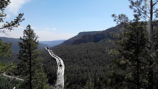
Blick vom Redondo Overlook

Der National Forest im Herbst

Eine Karte des Gebietes

Weblinks
Siehe auch
Einzelnachweise
- ↑ a b c „Land Areas of the National Forest“ (englisch; PDF 3,98 MB), auf www.fs.fed.us im September 2017, abgerufen am 17. Juni 2019
- ↑ "The National Forests of the United States" (englisch, PDF 0,36 MB), auf www.fs.fed.us, abgerufen am 17. Juni 2019
- ↑ "Jury finds power companies mostly liable for Las Conchas Fire" (englisch), auf www.wildfiretoday.com, abgerufen am 17. Juni 2019
- ↑ Laura Paskus: "Beyond The Concepts Of ‘Land Management’ Are Real People, Sacrifice" (englisch), auf www.newmexicopbs.org am 14. Juli 2017, abgerufen am 17. Juni 2019
Auf dieser Seite verwendete Medien

(c) Aaron Zhu, CC BY-SA 3.0
Redondo Overlook, Santa Fe National Forest, NM
.jpg)
Autor/Urheber: Thomas Shahan, Lizenz: CC BY 2.0
Atop Tesuque Peak Looking Towards Santa Fe Lake
_relief_location_map.png)
Autor/Urheber: TUBS
Location map of the USA (Hawaii and Alaska shown in sidemaps).
Main map: EquiDistantConicProjection : Central parallel :
* N: 37.0° N
Central meridian :
* E: 96.0° W
Standard parallels:
* 1: 32.0° N
* 2: 42.0° N
Made with Natural Earth. Free vector and raster map data @ naturalearthdata.com.
Formulas for x and y:
x = 50.0 + 124.03149777329222 * ((1.9694462586094064-({{{2}}}* pi / 180))
      * sin(0.6010514667026994 * ({{{3}}} + 96) * pi / 180))
y = 50.0 + 1.6155950752393982 * 124.03149777329222 * 0.02613325650382181
      - 1.6155950752393982  * 124.03149777329222 *
     (1.3236744353715044  - (1.9694462586094064-({{{2}}}* pi / 180))
      * cos(0.6010514667026994 * ({{{3}}} + 96) * pi / 180))
Hawaii side map: Equirectangular projection, N/S stretching 107 %. Geographic limits of the map:
- N: 22.4° N
- S: 18.7° N
- W: 160.7° W
- E: 154.6° W
Alaska side map: Equirectangular projection, N/S stretching 210.0 %. Geographic limits of the map:
- N: 72.0° N
- S: 51.0° N
- W: 172.0° E
- E: 129.0° W

Autor/Urheber: Artotem from Here, There, and..., Lizenz: CC BY 2.0
Santa Fe National Forest
(c) Aaron Zhu, CC BY-SA 3.0
Battleship Rocks, Santa Fe National Forest, NM

Autor/Urheber: snowpeak, Lizenz: CC BY 2.0
The Soda Dam — on Jemez Creek near Jemez Springs, in the Santa Fe National Forest, New Mexico.