Sankt-Paul-Insel (Alaska)
| Sankt-Paul-Insel | ||
|---|---|---|
 | ||
| Gewässer | Beringmeer | |
| Inselgruppe | Pribilof-Inseln | |
| Geographische Lage | 57° 11′ N, 170° 16′ W | |
| Fläche | 104 km² | |
| Einwohner | 532 (2000) 5,1 Einw./km² | |
| Hauptort | Saint Paul | |
 | ||
Die Sankt-Paul-Insel (englisch Saint Paul Island, aleutisch Tanax̂ Amix̂ oder Sanpuulax̂) ist die größte der vier Pribilof-Inseln und liegt nördlich der Aleuten im Beringmeer. Wie alle anderen Inseln dieser Inselgruppe ist auch die Sankt-Paul-Insel vulkanischen Ursprungs. Administrativ gehört die 104 km² große Insel zum US-amerikanischen Bundesstaat Alaska.
Geografie und Bevölkerung
| Sankt-Paul-Insel | ||||||||||||||||||||||||||||||||||||||||||||||||
|---|---|---|---|---|---|---|---|---|---|---|---|---|---|---|---|---|---|---|---|---|---|---|---|---|---|---|---|---|---|---|---|---|---|---|---|---|---|---|---|---|---|---|---|---|---|---|---|---|
| Klimadiagramm | ||||||||||||||||||||||||||||||||||||||||||||||||
| ||||||||||||||||||||||||||||||||||||||||||||||||
Monatliche Durchschnittstemperaturen und -niederschläge für Sankt-Paul-Insel
Quelle: wetterkontor.de | |||||||||||||||||||||||||||||||||||||||||||||||||||||||||||||||||||||||||||||||||||||||||||||||||||||||||||||||||||||||||||||||||||||||||||||||||||||||||||||||||||||||||||||||||||||||||||||||||||
- Heutige Siedlung auf der Sankt-Paul-Insel
- Küste des Beringmeers
Die Sankt-Paul-Insel hat ca. 530 Einwohner, der weitaus größte Teil davon sind Ureinwohner Alaskas vom Stamm der Aleuten.
Geschichte

1788 hatte Gawriil Loginowitsch Pribylow die Insel für Russland entdeckt. 1907 wurde die Kirche „Heilige Peters- und Paulskirche“ von Angehörigen der Russisch-Orthodoxen Kirche auf der Insel erbaut.
Infrastruktur
Anfang des 20. Jh. verkehrte hier die Feldbahn auf der Sankt-Paul-Insel. Neben Fährverbindungen zum alaskischen Festland verfügt die Insel auch über einen eigenen Flughafen.
Mammuts auf Sankt Paul
Auf der Sankt-Paul-Insel, die nach der letzten Eiszeit vor 13.000 Jahren von Alaska durch das steigende Meerwasser getrennt wurde, entdeckte man eine Population des Wollhaarmammuts, die noch bis ins mittlere Holozän dort überlebt hatte. Es handelt sich um relativ kleine Wollhaarmammuts, deren geringe Körpergröße jedoch nicht als eine vollständige Inselverzwergung wie auf der Wrangel-Insel angesehen wird. Die jüngsten Daten aus der Qagnax-Höhle von Sankt Paul liegen bei 5.725 BP (14C-Jahre), also etwa 3700 v. u. Z.[1][2]
Trivia

Die Insel – genauer die Halbinsel Novastoshnah (North East Point) – ist Schauplatz der Erzählung „Die weiße Robbe“ in Rudyard Kiplings „Dschungelbuch“.
„All these things happened several years ago at a place called Novastoshnah, or North East Point, on the Island of St. Paul, away and away in the Bering Sea.“
Der dieser Erzählung zugeordnete Liedtext „Lukannon“ bezieht sich auf die nach einem Pelzhändler namens Lukanin benannte[3] Bucht von Lukannon (Lukanin Bay) an der Ostküste.
Weblinks
- Sankt-Paul-Insel. In: Geographic Names Information System. United States Geological Survey, United States Department of the Interior (englisch).
Einzelnachweise
- ↑ J. M. Enk, D. R. Yesner, K. J. Crossen, D. W. Veltre und D. H. O’Rourke: Phylogeographic Analysis of the mid-Holocene Mammoth from Qagnax Cave, St. Paul Island, Alaska. Palaeogeography, Palaeoclimatology, Palaeoecology 273 (1–2), 2009, S. 184–190.
- ↑ Douglas W. Veltre, David R. Yesner, Kristine J. Crossen, Russell W. Graham und Joan B. Coltrain: Patterns of faunal extinction and paleoclimatic change from mid-Holocene mammoth and polar bear remains, Pribilof Islands, Alaska. Quaternary Research 2008, S. 40–50.
- ↑ https://www.kiplingsociety.co.uk/readers-guide/rg_lukannon1.htm
Auf dieser Seite verwendete Medien
Autor/Urheber: Jim Greenhill from Arlington and Durango, USA, Lizenz: CC BY 2.0
St. Paul Island, Alaska, on Nov. 6, 2010. About 500 people live on the island 775 miles west of Anchorage in the Bering Sea. The Alaska National Guard brought Christmas to the island early Nov. 6 as part of its 54th annual Operation Santa Claus outreach to the state's remote communities. (U.S. Army photo by Staff Sgt. Jim Greenhill) (Released)
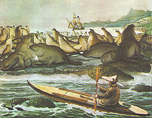
Die "Rurik" liegt vor der Insel Sankt Paul in der Beringsee. Gezeichnet vom Expeditionsteilnehmer Louis Choris im Jahr 1817.
St. Paul Island, Alaska, on Nov. 6, 2010. About 500 people live on the island 775 miles west of Anchorage in the Bering Sea. The Alaska National Guard brought Christmas to the island early Nov. 6 as part of its 54th annual Operation Santa Claus outreach to the state's remote communities. (U.S. Army photo by Staff Sgt. Jim Greenhill) (Released)
Lukannon Beach. Sand-dume [sic] Tracts, east shore of St. Paul's Island--Fur Seals playing in the surf--July 25, 1872
- Subject: Saint Paul Island (Alaska), Northern fur seal
- Geographic Subject: United States--Alaska--Saint Paul Island
- Tag: Coasts, Aquatic Mammals


