Saint-Morillon
| Saint-Morillon | ||
|---|---|---|
| ||
| Staat | ||
| Region | Nouvelle-Aquitaine | |
| Département (Nr.) | Gironde (33) | |
| Arrondissement | Bordeaux | |
| Kanton | La Brède | |
| Gemeindeverband | Montesquieu | |
| Koordinaten | 44° 39′ N, 0° 30′ W | |
| Höhe | 15–67 m | |
| Fläche | 20,40 km² | |
| Einwohner | 1.817 (1. Januar 2022) | |
| Bevölkerungsdichte | 89 Einw./km² | |
| Postleitzahl | 33650 | |
| INSEE-Code | 33454 | |


Saint-Morillon ist eine französische Gemeinde im Département Gironde in der Region Nouvelle-Aquitaine. Die Gemeinde liegt im näheren Einzugsgebiet der Stadt Bordeaux. Während Saint-Morillon im Jahr 1962 noch über 475 Einwohner verfügte, zählt man aktuell 1817 Einwohner (Stand 1. Januar 2022).
Die Gemeinde gehört zum Kanton La Brède und zum Arrondissement Bordeaux.
Baudenkmäler
Siehe: Liste der Monuments historiques in Saint-Morillon
Weinbau
Saint-Morillon ist ein Weinbauort in der Weinbauregion Graves und wird vom Fluss Gat-Mort durchquert.
 Kirche Saint-Morillon
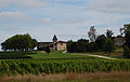 Château Bel-Air
 Mairie Saint-Morillon
Literatur
- Le Patrimoine des Communes de la Gironde. Flohic Éditions, Band 1, Paris 2001, ISBN 2-84234-125-2, S. 445–448.
Weblinks
Auf dieser Seite verwendete Medien

(c) Karte: NordNordWest, Lizenz: Creative Commons by-sa-3.0 de
Positionskarte von Frankreich mit Regionen und Départements


Autor/Urheber: PA, Lizenz: CC BY-SA 3.0
Dieses Gebäude ist in der Base Mérimée, einer Datenbank des französischen Kulturministeriums über das architektonische Erbe Frankreichs, aufgeführt, unter der Angabe PA00083791
Autor/Urheber:
|
Map data (c) OpenStreetMap contributors, CC-BY-SA _French_municipality_map.svg) • Shape files infrastructure: railway, highways, water: all originally by OpenStreetMap contributors. Status december 2011 *note: shown commune boundaries are from OSM dump May 2012; at that time about 90% complete |
Map commune FR insee code 33454.png

Autor/Urheber: Henry Salomé, Lizenz: CC BY-SA 3.0
Saint-Maurille church of Saint-Morillon (Gironde, France)

Autor/Urheber: Henry Salomé, Lizenz: CC BY-SA 3.0
Town hall of Saint-Morillon (Gironde, France)
Autor/Urheber: Contributeurs de OpenStreetMap, Lizenz: CC BY-SA 2.0
Saint-Morillon Limite communale