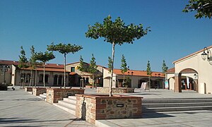
Saint-Jean-Pla-de-Corts
| Saint-Jean-Pla-de-Corts Sant Joan de Pladecorts | ||
|---|---|---|
| ||
| Staat | Frankreich | |
| Region | Okzitanien | |
| Département (Nr.) | Pyrénées-Orientales (66) | |
| Arrondissement | Céret | |
| Kanton | Vallespir-Albères | |
| Gemeindeverband | Vallespir | |
| Koordinaten | 42° 31′ N, 2° 48′ O | |
| Höhe | 71–208 m | |
| Fläche | 10,62 km² | |
| Einwohner | 2.258 (1. Januar 2021) | |
| Bevölkerungsdichte | 213 Einw./km² | |
| Postleitzahl | 66490 | |
| INSEE-Code | 66178 | |
 Saint-Jean-Pla-de-Corts | ||
Saint-Jean-Pla-de-Corts (auf Katalanisch Sant Joan de Pladecorts) ist eine französische Gemeinde mit 2258 Einwohnern (Stand 1. Januar 2021) im Département Pyrénées-Orientales in der Region Okzitanien. Sie gehört zum Arrondissement Céret und zum Kanton Vallespir-Albères. Der Ort liegt im Tal des Flusses Tech.
Ein Teil der landwirtschaftlichen Flächen dient dem Weinbau und die Weinberge liegen innerhalb der geschützten Herkunftsbezeichnungen Rivesaltes, Muscat de Rivesaltes und Côtes du Roussillon.
Geografie

Bürgermeister
- 1982–1989: Jean Patot
- seit 1989: Robert Garrabé
Bevölkerungsentwicklung
- 1962: 722
- 1968: 743
- 1975: 906
- 1982: 1040
- 1990: 1456
- 1999: 1775
Ab 1962 nur Einwohner mit Erstwohnsitz

Persönlichkeiten
- Ludovic Massé (1900–1982), Schriftsteller
Weblinks
Auf dieser Seite verwendete Medien
(c) Karte: NordNordWest, Lizenz: Creative Commons by-sa-3.0 de
Positionskarte von Frankreich mit Regionen und Départements
Autor/Urheber: Michiel1972, Lizenz: CC BY-SA 3.0
Population - Municipality code 66178.svg
Population Census 1962-2008Autor/Urheber:
|
Map data (c) OpenStreetMap contributors, CC-BY-SA  • Shape files infrastructure: railway, highways, water: all originally by OpenStreetMap contributors. Status december 2011 *note: shown commune boundaries are from OSM dump May 2012; at that time about 90% complete |
Map of French municipality
Autor/Urheber: Fabricio Cardenas, Lizenz: CC BY-SA 3.0
Square Guy Malé à Saint-Jean-Pla-de-Corts


