Rysa Little
| Rysa Little | |
|---|---|
| Gewässer | Nordsee |
| Inselgruppe | Orkney |
| Geographische Lage | 58° 51′ 36″ N, 3° 11′ 45″ W |
Contains Ordnance Survey data © Crown copyright and database right, CC BY-SA 3.0 | |
| Fläche | 32 ha |
| Höchste Erhebung | 20 m |
| Einwohner | unbewohnt |
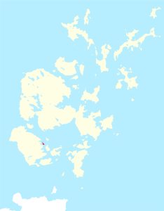
Rysa Little ist eine unbewohnte Insel im Archipel der Orkney-Inseln. Die Fläche der Insel beträgt 32 Hektar, die höchste Erhebung liegt 20 Meter über dem Meeresspiegel. Sie liegt im Scapa Flow, in der Nähe der Inseln Hoy und Cava. Zwischen Rysa Little und der Insel Fara kam es 1919 zur massenhaften Selbstversenkung von internierten deutschen Kriegsschiffen. Heute ist Rysa Little unbewohnt.
Herkunft des Namens
Rysa Little ist altnordisch und bedeutet so viel wie „ein Häufchen Steine“.
Weblinks
Auf dieser Seite verwendete Medien
2007 Flag of Orkney
My own vector of the official flag of the Isles of Orkney, Scotland, created using Inkscape. This version is based upon the official version designed by Duncan Tullock of Birsay and voted for by the people of Orkney and approved by the Court of the Lord Lyon in 2007 from a short list of 5 designs. It is a Nordic Cross, in keeping with the flag's unofficial predecesor the Cross of St Magnus, and for which, according to Mr Tullock, "Orkney has always been represented by red, so that was an obvious choice. The yellow symbolizes the royal standards of both Scotland and Norway and blue is for Scotland, and also for the sea that surrounds us".
Contains Ordnance Survey data © Crown copyright and database right, CC BY-SA 3.0
Rysa Little in Orkney


