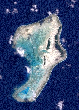
Rowa-Inseln
| Rowa-Inseln | ||
|---|---|---|
| Satellitenbild der Rowa-Inseln | ||
| Gewässer | Korallenmeer | |
| Archipel | Banks-Inseln | |
| Geographische Lage | 13° 37′ S, 167° 31′ O | |
| Anzahl der Inseln | 6 | |
| Hauptinsel | Rowa | |
| Länge | 9 km | |
| Breite | 5,2 km | |
| Landfläche | 10 ha | |
| Gesamtfläche | 30 km² | |
| Einwohner | unbewohnt | |
(c) Alexandre François, CC BY 3.0 | ||
Die Rowa-Inseln, auch Reef Islands genannt, sind ein Atoll in den Banks-Inseln der Provinz Torba, der nördlichsten Provinz von Vanuatu, etwa acht Kilometer nordöstlich der Insel Vanua Lava.
Das Korallenriff, das die Inseln umfasst, ist einschließlich der Lagune rund 30 km² groß. Die Landfläche der fünf (Motu) (Atollinseln) beträgt dagegen nur rund zehn Hektar. Die Inselchen, die alle im Nordosten des Atolls liegen ragen kaum mehr als zwei Meter über den Meeresspiegel hinaus. Die fünf[1] Inseln sind:
- Lomeur (Île de Sable, Île Moïe, Sanna, Sana)
- Enwut (Île Anouit, Enwot, Anwet)
- Watansa (Wotansa)
- Rowa (Ro, Île Rowo)
- Wosu (Île Wosou)
- Peten
Andere Quellen nennen auch Lavap.
Die Inseln haben eine Gesamtfläche von 10 Hektar. Enwut ist die größte Insel. Nur die Hauptinsel war früher bewohnt. 1944 wurden 20 Bewohner gezählt. Diese siedelten nach einem schweren Zyklon auf die 18 km nordwestlich gelegene Insel Uréparapara um, wo sie bereits Landnutzungsrechte besaßen.[2]
Einzelnachweise
Auf dieser Seite verwendete Medien
Autor/Urheber: Eric Gaba (Sting - fr:Sting), Lizenz: CC BY-SA 3.0
Blank physical map of Vanuatu in Oceania, for geo-location purpose.
(c) Alexandre François, CC BY 3.0
I have drawn this map of the Banks Islands (Vanuatu) based on several other maps showing sufficient precision. I paid special attention to the transcription of place names, based on personal fieldwork in the Banks Islands, and professional knowledge of the various local languages.
Rowa Islands in the Banks Islands, Vanuatu. Landsat 7 image


