Rotkopf (Mangfallgebirge)
| Rotkopf | ||
|---|---|---|
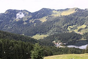
 Stolzenberg (links), Rotkopf (Mitte) und Roßkopf (rechts) im bayerischen Mangfallgebirge südöstlich des Spitzingsees (rechts unten) | ||
| Höhe | 1602 m ü. NN | |
| Lage | Bayern, Deutschland | |
| Gebirge | Mangfallgebirge | |
| Koordinaten | 47° 38′ 54″ N, 11° 51′ 59″ O | |
| Normalweg | vom Spitzingsee | |
Der Rotkopf ist ein 1602 m hoher Berg im Mangfallgebirge. Der Berg ist als einfache Bergwanderung vom Spitzingsee zu erreichen. Übergänge zu Stolzenberg, Roßkopf und Stümpfling.
Weblinks
Auf dieser Seite verwendete Medien
Autor/Urheber: Grundkarte TUBS, Relief Alexrk2, Lizenz: CC BY-SA 3.0
Physische Positionskarte Bayern, Deutschland. Geographische Begrenzung der Karte:
Autor/Urheber: Baiogrammaticus, Lizenz: CC BY-SA 4.0
Stolzenberg (links, 1609m), Rotkopf (Mitte, 1602m) und Roßkopf (rechts, 1580m) im bayerischen Mangfallgebirge südöstlich des Spitzingsees (rechts unten)


