Rochester (Northumberland)
| Rochester | |||
|---|---|---|---|
| |||
| Koordinaten | 55° 17′ N, 2° 16′ W | ||
| Basisdaten | |||
| Staat | Vereinigtes Königreich | ||
Landesteil | England | ||
| County | Northumberland | ||
| ISO 3166-2 | GB-NBL | ||
| North East England | |||
 (c) John Watson, CC BY-SA 2.0 Dere Street nach Bremenium | |||
Rochester ist eine Kleinstadt im nördlichen Northumberland (England). Es liegt nordöstlich von Otterburn an der Straße von Corbridge nach Jedburgh. Die Stadt gehört zum Parlamentswahlkreis von Hexham.
Geschichte
Rochester ist der Ort des ehemaligen römischen Forts Bremenium, das erbaut wurde, um die wichtige Römerstraße (heute Dere Street) zu schützen, die mitten durch die Ortschaft geht. Diese Straße verband Eboracum (York) mit dem Antoninuswall im heutigen Schottland. Eine militärische Einheit des römischen Heeres, die Cohors Primae Lingonum Equitata, die vornehmlich aus Lingonen bestand, war u. a. dort stationiert. Von ihr fand man einen Schrein mit einer Inschrift für die Gottheit Matunus.
Hier befindet sich mit den Three Kings, rund sechs Kilometer nordwestlich, ein Vier-Pfosten-Steinkreis (engl. Four-poster stone circle), von dem nur noch drei Steine stehen, der vierte ist umgefallen. Dieses Monument besteht aus vier Menhiren, die die Ecken eines Quadrats markieren. Der schwerste der Steine wiegt 2,5 t. Es handelt sich um eine Grabanlage, in ihrem Zentrum befand sich ein kleiner gemauerter Schacht für die Asche des Toten. Die Steinsetzung stammt aus der Bronzezeit und ist vergleichbar mit den Goatstones in der Nähe der Ravensheugh Crags, ebenfalls in Northumberland.
Bildergalerie
 (c) Oliver Dixon, CC BY-SA 2.0
Die Three Kings
 (c) John Watson, CC BY-SA 2.0
Römergrab an der Dere Street
 (c) John Watson, CC BY-SA 2.0
Schulanbau aus Römersteinen
 (c) Walter Baxter, CC BY-SA 2.0
Kriegerdenkmal
 (c) Walter Baxter, CC BY-SA 2.0
Souvenirladen
 (c) Walter Baxter, CC BY-SA 2.0
rekonstruierter Bauernhof
Weblinks
Auf dieser Seite verwendete Medien

(c) Walter Baxter, CC BY-SA 2.0
War memorial at Rochester Interesting memorial by the A68.

(c) Walter Baxter, CC BY-SA 2.0
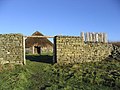
Woolaw enclosed farmstead at Brigantium The enclosed farmstead is one of several located on the south side of Redesdale. These sites are thought to date from the Romano-British period (around 80AD to 410AD) and were the dwellings of the native Brigantian Celts. We know that the substantial enclosure walls were built of stone, though the wooden palisade has been interpreted. The stone-walled roundhouses replaced earlier ones made of wood. (Source: information board on site) Brigantium is an archaeological reconstruction centre situated in the village of Rochester.

(c) John Watson, CC BY-SA 2.0
Old schoolhouse porch made from Roman stones brought from the fort at Bremenium This is one of the most curious buildings I have seen in Northumberland, the old schoolhouse porch at Rochester is built entirely of Roman stones brought from the nearby fort of Bremenium. You can clearly see the gutterings from the side of roads, and the two rounded stones intended for 'ballistae'
(c) John Watson, CC BY-SA 2.0
Rochester Looking back to Rochester on the road to Bremenium

(c) Walter Baxter, CC BY-SA 2.0
Shop and cafe at Brigantium Brigantium is an archaeological reconstruction centre situated in the village of Rochester on the A68 trunk road north of Otterburn.

(c) Oliver Dixon, CC BY-SA 2.0
The Three Kings, Redesdale Forest This is the site of a Bronze Age burial which took place about 3,500 years ago. The person who died was cremated and their remains placed in a small stone-lined grave in the middle of the site.
He must have been of some importance because the burial is marked by four enormous standing stones. One of the stones fell down many years ago and the site became known as "The Three Kings". The largest stone weights 2.5 tons.
The Forestry Commission have constructed a forest walk to the site from the Blakeburnhopehaugh car park NT7800.
(c) Karte: NordNordWest, Lizenz: Creative Commons by-sa-3.0 de
Positionskarte des Vereinigten Königreichs

(c) John Watson, CC BY-SA 2.0
Roman tomb on Deer Street, near Rochester Northumberland