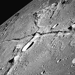
Rima Ariadaeus
| Rima Ariadaeus | ||
|---|---|---|
 | ||
| Rima Ariadaeus mit Silberschlag (links) und Silberschlag A (Aufnahme von Apollo 10) | ||
| Position | 6,48° N, 13,44° O | |
| Durchmesser | 247 km | |
| Siehe auch Gazetteer of Planetary Nomenclature | ||
Die Rima Ariadaeus ist eine geradlinige Rille auf dem Erdmond mit mehr als 300 Kilometern Länge auf den selenografischen Koordinaten 6,4° N, 14,0° O. Es wird vermutet, dass sie entstanden ist, als ein Bereich der Mondkruste zwischen zwei parallelen Bruchlinien absank und so einen Grabenbruch schuf. Die mondgeschichtlich relativ junge Struktur wird nur von wenigen Kratern überdeckt.
Namensgeber ist der Krater Ariadaeus, der gleichzeitig ihr östliches Ende markiert.
Weblinks
- Rima Ariadaeus auf The-Moon Wiki
- Rima Ariadaeus im Gazetteer of Planetary Nomenclature der IAU (WGPSN) / USGS
Auf dieser Seite verwendete Medien
NASA lunar chart of equatorial region (latitudes 45S to 45N) 1 : 10.000.000 (LPC-1).
Cutting across the center of this image from the Apollo 10 is the Rima Ariadaeus, a linear rille. The crater to the south of the rille in the left half of the image is Silberschlag. The dark patch at the top right is the floor of Boscovitch crater (a map). Photo by Apollo 10, 1969.


